
“Dutch Town” was a short-lived phenomenon that may have been Charleston’s first ethnic neighborhood. It emerged in the late 1750s and its growth was fueled by the arrival of large numbers of German immigrants in the years leading up to the American Revolution. Unlike many other ethnic neighborhoods, the clustering of these German immigrants into an urban enclave was not motivated by issues of prejudice or segregation. Rather, the birth of Dutch Town in mid-eighteenth-century Charleston was an interesting response to a specific set of circumstances and real estate opportunities that existed at that moment. As those circumstances changed, however, and its German denizens moved on to greener pastures, Dutch Town’s identify faded into obscurity more than two centuries ago.
Before we burrow too deeply into the history of Charleston’s Dutch Town, we need to correctly identify the people who inspired the name of this long-forgotten neighborhood. Despite the name, Dutch Town was not a neighborhood full of Dutch immigrants from the Netherlands. The “Dutch” in this town refers instead to German-speaking settlers from the Electorate of the Palatinate, in the southwest area of modern Germany, who came to South Carolina in large numbers around the middle of the eighteenth century. The German word for “German” is Deutsche, which English-speaking American colonists incorrectly Anglicized as “Dutch.” There were certainly legitimate Dutch settlers in early South Carolina, of course, but the inhabitants of Charleston’s Dutch Town were every bit as German as the more famous Pennsylvania Dutch, who were, or course, really Deutsche.
The story of Dutch Town begins in the middle of the eighteenth century, but I’d like to begin our tour of the neighborhood in the 1670s. Why? Because the physical location of Dutch Town is rooted in a series of mathematical errors made long before the first Germans arrived in South Carolina.
Around the year 1672 a team of surveyors laid out the town we call Charleston on the peninsula between the Ashley and Cooper Rivers. Their hand-drawn plan, which included a grid of streets oriented roughly on east-west and north-south axes and more than 300 half-acre lots, became known as the “Grand Model” of the town. You’ll find illustrations of the Grand Model of Charleston in a number of history books, and anyone interested in studying the physical development of the town needs to be intimately familiar with the Grand Model.
As a map of the early town, however, the Grand Model of Charleston wasn’t perfect. In fact, it was a terribly flawed document. It turns out that the surveyors who drew the Grand Model on paper in the early 1670s made some significant errors in their field work. That is, when they laid out the streets and lots on the ground with stakes and surveyor’s chains, they made some serious mathematical mistakes. I’ll save the details of that story for a later program.
Because Charleston grew slowly in its early years, it wasn’t until the 1720s that people began to realize that some streets and lots were not in the right place. Things started out alright on the east side of town, against the Cooper River waterfront, but the surveying errors became more pronounced as one moved north and west, toward the Ashley River waterfront. Throughout the 1730s, the South Carolina legislature discussed methods of rectifying the problems, but no actions were taken until the mid-1740s.
 Meanwhile, the earliest German Palatine immigrants arrived in South Carolina in 1732 and throughout the rest of 1730s. Most of them moved inland, to claim land around the newly-created townships, but a small portion remained in Charleston. The migration of Germans was curtailed at the end of the 1730s, however, by the outbreak of a new war between Britain and Spain that became known at the War of Jenkins’ Ear. In response to the renewed threat of Spanish invasion, the South Carolina legislature commenced building new fortifications around Charleston. Between the late 1730s and the late 1740s, new walls, moats, and bastions appeared on the urban landscape. At first the legislature focused on expanding the fortifications on the south and east sides of the town, at White Point and along the Cooper River waterfront, but eventually the government realized that they had left the north and west parts of the town completely open to attack.
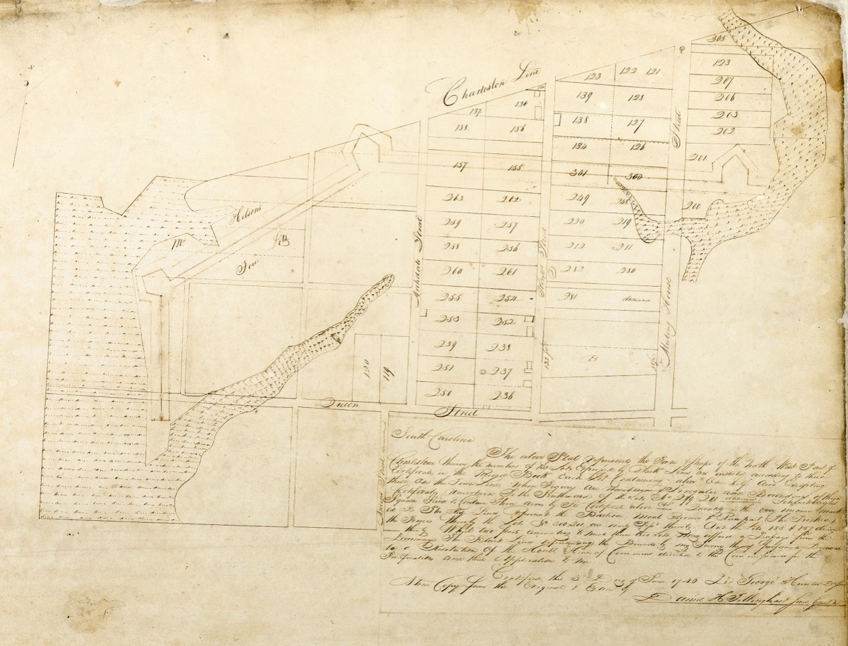
In the mid-1740s, engineers and laborers corrected this oversight by creating an earthen wall and moat, measuring nearly a half-mile in length and punctuated with at least three bastions, to protect the Charleston’s sparsely-populated northwestern frontier. At the same time as this large construction project, South Carolina’s surveyor general, George Hunter, re-surveyed all of the property west of Meeting Street and north of Queen Street, which at that time was almost entirely vacant. In June of 1746, Hunter completed his plat of re-survey, as he called it, that served as the new version of the Grand Model for the northwest portion of the town. The surveyor general’s original plat, created in 1746, does not survive, but the South Carolina Department of Archives and History in Columbia holds a “true copy” made in the 1820s by the state surveyor general, Daniel H. Tillinghast.
How is this background information relevant to the story of Dutch Town? Let me explain. The neighborhood called Dutch Town was comprised of eight half-acre lots in the northwest corner of colonial Charleston, the lots numbered 254 through 261. If you open a copy of the Grand Model of the town created in the 1670s and look for those lot numbers, you will find that they are not contiguous, and don’t resemble a neighborhood. Rather, the lot numbers that comprised Dutch Town only make sense as a contiguous block of lots when you look at George Hunter’s 1746 resurvey of that neighborhood.
 As I mentioned a moment ago, at the time of George Hunter’s resurveying and the fortification construction in the mid-1740s, the northwest part of urban Charleston was, in fact, pretty rural looking. King Street certainly existed because it was the only road in and out of the town, but Archdale Street and other streets in that neighborhood existed only on paper. In the wake of George Hunter resurveying, however, the streets and lots were laid out anew, and were ready for development. We’re talking about a couple of dozen acres that were owned by a handful of investors.
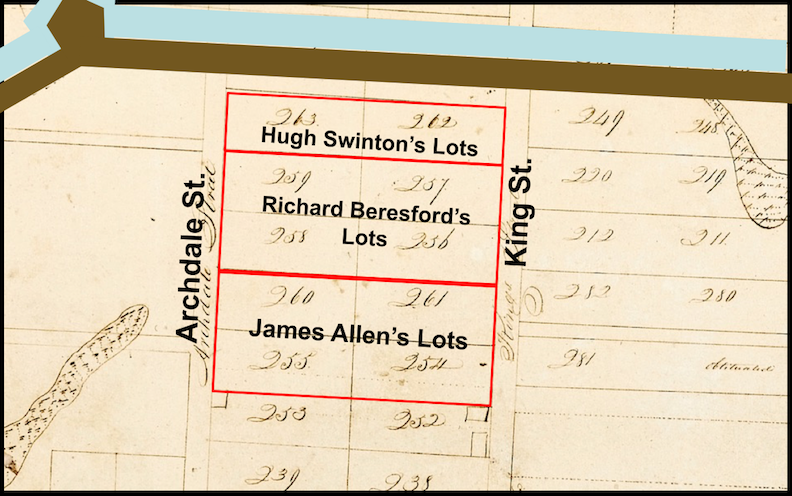
James Allen, for example, owned four contiguous “Grand Model” lots between King and Archdale Streets, numbered 254, 255, 260, and 261. Immediately north of Mr. Allen’s lots, Richard Beresford also owned four contiguous lots between King and Archdale Streets, numbered 256, 257, 258, and 259. To the north of Mr. Beresford, there were a few other lots, but they were either partially or totally obscured by the line of fortifications constructed in 1745. Similarly, there was some vacant land to the west of Archdale Street, but there was also a public powder magazine, a Work House, a Poor House, a public burying ground, and the southwestward continuation of the new fortifications. That area, around what is now Magazine Street, would be developed later, after the American Revolution, so we’ll ignore it for the time being.
In early January 1759, a group of eight men representing the nucleus of Charleston’s first German Lutheran congregation purchased a vacant lot from James Allen. More specifically, they purchased Lot No. 255, which, according to George Hunter’s 1746 plat of re-survey, measured 97 feet along the east side of Archdale Street and 232 feet deep. To facilitate access to this property, both James Allen, who still owned the adjacent lots, and his new German neighbors sacrificed a few feet of their respective lots to create an alley that ran perpendicular to Archdale and King Streets. At first Mr. Allen called this new pathway “Allen Street,” but that name wasn’t widely used. As soon as the Germans began building their wooden church on the south side of the new alley, most people in Charleston began calling it “Dutch Church Alley,” or as one newspaper notice described it in 1767, “the Lane leading out of King-street to the Dutch Church.”
The conveyance of Lot No. 255 to a group of German investors in January 1759 marks the beginning, we might even say the “cornerstone,” of Dutch Town. Here a group of German immigrants pooled their money and put down permanent roots on behalf of their fledgling community. As individuals, however, the vast majority of the Deutsche-speaking newcomers could not afford to purchase property or build their own houses. For a generation or two after their arrival, most of them had to live and work in rented property until they could generate the capital and credit needed to settle in a more permanent situation. Meanwhile, as more German Palatines sailed into the port of Charleston in the 1760s, the town grew crowded and the supply of affordable housing rapidly diminished. Barracks built by the provincial government to house British soldiers became the first temporary shelter for hundreds of new arrivals. Charleston needed some new housing stock, and real estate speculators like James Allen and Richard Beresford were quick to seize this market opportunity.

The 1759 conveyance of Lot No. 255 from James Allen to the trustees of the German Lutheran church might have been the spark that fueled the growth of Dutch Town, but the neighborhood didn’t appear overnight. It took time to clear the land, divide the lots, lay out the streets, and erect homes and shops. In fact, the earliest use of the name “Dutch Town” that I’ve been able to find is late June 1770, when a woman named Margaret M’Intire offered to teach sewing and knitting at her house “in Dutch Town, opposite Dr. [Johann] Swint’s [Schwint]” in King Street. I’m sure the name was in use locally for some time before 1770, but I haven’t yet finished the tedious process of trolling through surviving documents in search of an earlier reference.
From the beginning, most of the subdivided building lots in Dutch Town were quite small. A few generously-sized corner lots were large enough to attract investors who built brick buildings, but the vast majority of the new dwellings that appeared in the neighborhood were modest one-and-a-half story wooden tenements built on low brick foundations. How do we know this? Because a number of real estate advertisements in the Charleston newspapers of the 1760s through the 1770s actually describe the buildings available for sale and for rent in the area between King and Archdale Streets. Similarly, there are deeds of sales and lease agreements recorded at the office of the Register of Mesne Conveyance that provide valuable descriptions.
In June of 1760, for example, the widow Elizabeth Collis leased a small vacant lot on the west side of King Street, just a bit south of the new Dutch Church Alley, to George Gardner for £10 South Carolina currency per year for seven years. In exchange for this very low rent, Gardner promised to build and maintain one wooden tenement measuring fifteen feet on King Street, thirty feet deep, one story high on a brick foundation, with a “Dutch roof.” The interior was to measure eight feet from floor to ceiling and seven-and-a-half feet from the eaves to the peak of the roof. The term “Dutch roof” was commonly used in colonial America to describe what builders would now call a “gambrel” roof. That is, a pentagonal-shaped roof profile, rather than triangular, which provides extra headroom below the rafters and turns the attic into useable living space.
 Similarly, in February 1771 and October 1772, an agent of Richard Beresford advertised to lease several small wooden houses in Dutch Town, all featuring similar proportions and Dutch roofs like the house George Gardner was required to build in 1760. From these advertisements, and others from that era, we learn that German folks are indeed living in Dutch Town, and sometimes multiple families are sharing cramped quarters. Advertisements for goods and services tell us that this neighborhood was inhabited by bakers, blacksmiths, washers, coopers, and wheelwrights, among other tradesmen and women. I n short, Charleston’s Dutch Town in the decade before the American Revolution was a modest, bustling, working class, immigrant neighborhood just within the limits of the town.
Dutch Town continued to thrive into the 1780s and 1790s, but the neighborhood was definitely changing. Many of the German families who had settled in the neighborhood in its earliest days were moving away. As immigrants became established and prospered, they acquired the capital and credit necessary to own their own property and to build larger houses elsewhere in town. The new neighborhood of Harleston, just northwest of Dutch Town, and the new boroughs just north of the city limits, offered fresh opportunities for second and third generation families who could afford to move up in the world.
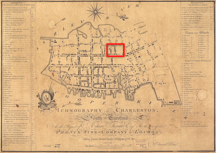
You can get a good sense of the physical context of Dutch Town by looking at a map called the “Ichnography of Charleston,” which was published in 1790 by the Phoenix Fire Insurance Company of London. This valuable map, which was based on surveys made in 1788, tells us that “Dutch Church Alley,” adjacent to St. John’s Lutheran Church, was thirteen feet wide, while Beresford Street was twenty-five feet wide. Those two short streets, running east-west between Archdale and King Streets, are the only streets in Dutch Town at that time.
A very similar map, published in 1802 within J. J. Negrin’s New Charleston Directory, informs us that the old Dutch Church Alley has been re-christened as Clifford Street. It’s unclear exactly when that change took place, but it occurred sometime in the 1790s, after Mr. John Clifford became the dominant landlord at the southwest corner of King Street and the narrow lane leading to the German church. Furthermore, Negrin’s 1802 map includes two additional streets at the northern edge of Dutch Town. Approximately 130 feet north of Beresford Street you’ll find Swinton’s Lane, a narrow thoroughfare cut through the property of Mr. Hugh Swinton, who acquired the lots numbered 262 and 263 on George Hunter’s 1746 plat of re-survey.

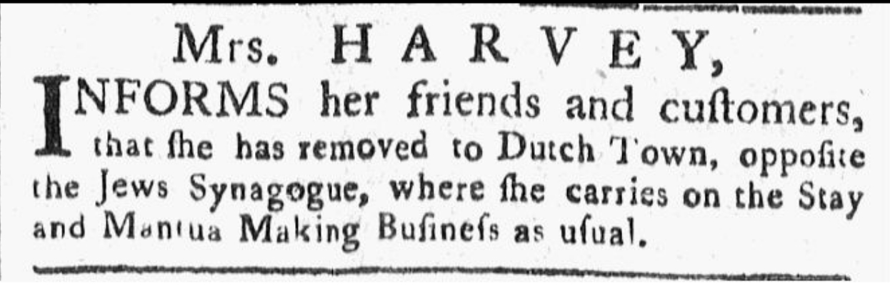
As the eighteenth century drew to a close, Dutch Town became less Deutsche, but it continued to be a modest working-class neighborhood inhabited by people on the lower end of the socio-economic ladder. In the South Carolina Weekly Gazette of 16 August 1783, for example, one Mrs. Harvey advertised that she had removed her sewing business “to Dutch town opposite the Jews Synagogue.”
In the Charleston Morning Post of 9 November 1786, Anthony Jankoffsky advertised to sell two tenements in Dutch Town, one of which included an upper room “which is the synagogue for the Portuguese Jews Congregation.” Similarly, the first Irish Catholic congregation in Charleston worshiped briefly, perhaps only a few months, in a rented building in Dutch Town. Both of these congregations, coincidentally, moved to more permanent quarters on Hasell Street before the end of the 1780s.
By the late 1790s, Dutch Town was quietly fading away. In Charleston’s City Gazette in October 1799, for example, John O’Kelly announced the opening of his Evening School at “No. 19, Beresford-street, formerly called Dutch-Town.” In the ensuing years, the number of references to Dutch Town in surviving documents declined rapidly. Having searched through property records and historic newspapers, the latest reference to Dutch Town that I’ve found appeared in the Charleston Investigator on May 3rd, 1813, when the celebrated Jewish intellectual Isaac Harby informed the public that he had “moved his school to that very pleasant and central situation, No. 17 Beresford-street, (commonly called Dutch-town) a few doors from the corner of King Street.” Among the earliest surviving records of free persons of color paying the annual “capitation tax” in Charleston, which are tentatively dated somewhere in the range of ca. 1811 to 1817, there appears one Rose Robion residing in Dutch Town. So it appears that by the end of the 1810s, the name “Dutch Town” had gradually disappeared from the Charleston lexicon.

Following the demise of the name ‘Dutch Town,” the neighborhood went through several cycles of growth and decay. In 1818 the German-American congregation at St. John’s Lutheran Church dedicated their new brick chapel and began to dismantle the old one. After the old building came down, the City of Charleston cleared away some additional wooden structures and widened Clifford street to its present dimensions in 1819. The following year the city began widening Parsonage Lane and incorporated it into Market Street. On the 27th of April 1838, a massive fire burned all of Swinton’s Lane and moved southeastwardly to Ansonborough. In the aftermath of the fire, the City of Charleston widened parts of King Street and renamed the improved Swinton’s Lane as Princess Street.
The most notorious change in the neighborhood came in the early years of the twentieth century, when the short block of Beresford Street became known as the heart of Charleston’s red-light district. Everyone seemed to know that brothels and other houses of ill repute dominated the street, but the city did little to address the issues. Only after U.S. military leaders applied political pressure in 1941 did City Council finally evict vice and immorality from Beresford Street. In March of 1942 the remaining people who owned property along the street petitioned City Council for permission to change its name. Beresford Street was tainted by the past, they said, and they wanted a new name that would be free of social stigma. City Council agreed, and started brainstorming about a new moniker for the street. Casting an eye around the Council Chambers in City Hall, a member sighted a plaster bust of Robert Fulton, of steamship fame, and suggested the name Fulton Street. After a brief debate, the motion was adopted, and that was the end of Richard Beresford’s legacy.
The original small homes and narrow lanes that once defined Dutch Town are long gone, but it’s still a charming part of Charleston that hundreds of tourists see every day. Now that you know the story of the neighborhood, perhaps you’ll be inclined to take a stroll around Dutch Town and see some familiar sights through a new historical lens.
NEXT: A Short History of Philadelphia Alley
PREVIOUSLY: Governor’s Bridge and the Sinkhole of 2017
See more from Charleston Time Machine