
Have you recently experienced some frustration with your daily Lowcountry commute? Do you find yourself wishing for an alternative to the gridlock that is crippling our local highways? If so, then I’ve got a story for you. In the past, Charleston-area commuters once had a variety of transportation options, including trains, trolleys, omnibuses, and bicycles. Today we’re going to talk about the predecessor to the modern water taxi—the ferries that once plied across the Cooper River, shuttling people, animals, and vehicles between Charleston, Daniel Island, and Mount Pleasant. If you’re looking for an alternate mode of transportation to ease your frustration, I recommend you begin with a journey back to a time when traveling was more of a relaxing adventure.
Let’s begin with some big background issues that will serve as a foundation for all the ferry details to come. First, it’s important to recognize that during the first two and a half centuries of South Carolina’s existence, there was no direct public funding for transportation infrastructure. Prior to the establishment of the state Highway Department in 1917, private citizens were, by and large, responsible for the creation and maintenance of all public roads, bridges, and ferries within their respective neighborhoods. Time doesn’t permit a detailed explanation of this ancient system right now, so I’ll summarize some of the early legal parameters relating to ferries.
As European colonists spread across the coastal region of South Carolina in the late 1600s and early 1700s, they established dozens of ferries—at least one over every river—as a means to facilitate settlement and trade. Any man could build a ferry boat and charge customers for passage across a river, of course, but centuries of prior experience informed colonists that complaints would eventually arise about excessive fees, poor service, and encroachments on private property. To prevent such issues, the provincial government of South Carolina followed the English practice of awarding licenses or franchises to ferry operators, who in turn would be bound by law to offer specific services. These ferry franchises were usually good for seven or fourteen years and could be renewed indefinitely as long as the franchisee provided reasonable services. Ferry owners were required to maintain their boats and causeways in good repair, to offer service on demand (day or night), and to charge tolls according to a fixed schedule of prices. Customers who were denied service, or received unsatisfactory service, or who were charged irregular fees, could complain to the government, which had the power to revoke the owner’s license or to refuse to renew the franchise. In order to prevent unnecessary competition, the law also specified that ferries should be located at least three miles apart. Prior to the middle of the nineteenth century, these rules defined the transportation realities for everyone traveling across the river deltas of the South Carolina lowcountry.[1]
There were dozens of ferries in early South Carolina, and each one has its own interesting history. In Charleston County alone, there were several long-standing ferries over the Ashley, Cooper, and Stono rivers. Back in August of 2017, I did a program about the long history of the Ashley Ferry (more recently known as Bee’s Ferry), which served as a principal crossing of the Ashley River for a century and a half. At some point in the future I’ll have to assemble a program about this history of Stono Ferry, but for the moment I’d like to concentrate on ferries over the Cooper River. More specifically, I’m going to focus on ferries crossing between the peninsula of Charleston and various points on the east bank of the Cooper River.[2]
For just over two hundred years, ferries boats played an important role in the of daily life of nearly everyone in the Charleston area. By transporting people, animals, and vehicles across the wide Cooper River, they facilitated culture and commerce and growth. By charging tolls for passage, and by enforcing laws designed to limit the mobility of enslaved people, however, these ferries also served to check the movements of our poor and disenfranchised inhabitants who formed the majority of our population. In short, the history of ferries across the Cooper River is an important topic for anyone trying to understand the mobility and transportation issues that shaped our community in the past and that continue to dog us today. In an effort to give due justice to this topic, I’m going to divide it into two parts—the first dealing with the first century of rising ferry traffic across the river, and the second part dealing with the second century of ferries, including both the zenith and the collapse of this ancient mode of transportation in the mid-twentieth century.
Colonial-Era Ferries across the Cooper River:
The first ferry to connect Charleston to the parish of Christ Church (east of the Cooper River and south of the Wando River) was established by William Watson in 1733. In September of that year, the provincial legislature empowered Watson, the owner of a plantation at Hobcaw Point, to operate a ferry and to create a new road leading from the “high road” through the rural parish, past the parish church, directly to his ferry.[4] The precise location of Watson’s ferry landing is unclear, but it was probably located somewhere on the south side of what is now called Remley’s Point. Like Codner’s Ferry on Daniel Island, the Hobcaw Ferry, as it was generally known, served for a while as the principal terminal for travelers commuting along the coastline to and from Charleston, using what became known as the Georgetown Road (now called Highway 17).
A second ferry connecting Charleston to Christ Church Parish commenced in June 1748, when mariner Henry Gray obtained permission from the legislature to operate a ferry from his property near the southeast side of Shem Creek.[5] Between 1748 and 1940, this location, commonly called Haddrell’s Point, evolved into the principal ferry landing east of the Cooper, although its use was not continuous over the years. Henry Gray, for example, sold his ferry property in 1749 or 1750 to Jacob Motte, who apparently did not sustain the ferry service for very long.[6] In a 1765 newspaper advertisement, for example, Mr. Motte’s plantation near Shem Creek and Haddrell’s Point was described as a place “where a late ferry was kept.”[7]
In the years just before the American Revolution, a number of important changes took place in the ferry service across the Cooper River. In the autumn of 1764, Joseph Scott took over the ferry formerly known as Codner’s Ferry, plying between his property on Daniel Island and Charleston Neck, and in the spring of 1765 he petitioned the provincial legislature for their endorsement. At the same time, Captain Clement Lempriere (also spelled Lampriere), a veteran mariner, likewise petitioned the legislature to re-activate the old ferry from his property at Hobcaw Point, formerly occupied by William Watson. The legislature granted both requests by passing an act in August 1765, and all seemed well for the moment.[8]
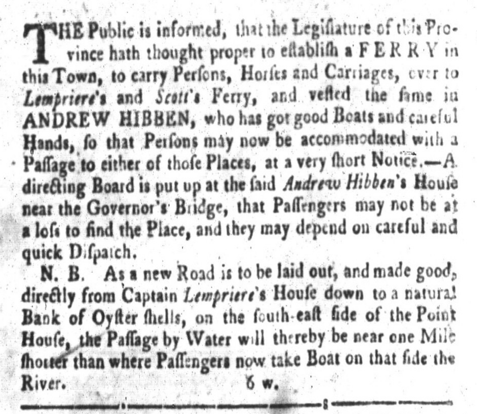
Joseph Scott died in May 1766, however, and his heirs discontinued the ferry service. Meanwhile, across the Wando River at Hobcaw Point, Captain Lempriere wasn’t operating his ferry with the consistency and punctuality required by law. Seeing this lapse in service across the Cooper and Wando Rivers, an Englishman named Andrew Hibben inaugurated a new ferry service in September 1769. At that time, Hibben advertised a ferry route from Charleston to Hobcaw Point, and from Hobcaw to Scott’s Ferry on Daniel Island.[9] This service encroached on the ferry franchises held by Clement Lempriere and the heirs of Joseph Scott, of course, so the aggrieved parties complained to the provincial government. After hearing several petitions and reports on the matter, the South Carolina legislature determined that Lempriere and the heirs Scott were in violation of the terms of their franchises, and so they empowered the interloper Hibben to continue his ferry business.[10] On the eve of the American Revolution, therefore, Andrew Hibben held a virtual ferry monopoly across the Cooper River, plying between Hobcaw Point and a hard beach near the east end of Pinckney Street in Charleston.[11]
Ferry Service After the American Revolutionary War:
Meanwhile, across the Wando River in Christ Church Parish, Andrew Hibben embarked a radical change in his ferry service during the American Revolution. His original service, established shortly before the war, landed at properties owned by other men, at Hobcaw Point and at Scott’s Ferry. During the war, however, Hibben purchased a tract of land at the southeast end of Shem Creek known as Haddrell’s Point, near a new suburban development called Greenwich Village (established in 1766). Here he established a new ferry route to Charleston, known as Hibben’s Ferry, and leased the business to Allen Bolton.[15] After the death of Andrew Hibben in 1784, and of Allen Bolton in May 1786, control of Hibben’s ferry passed to James Hibben, who continued its operation well into the nineteenth century. During his proprietorship, the newly-incorporated City of Charleston developed its first proper ferry landing in 1787, at a new public dock at the east end of Queen Street, adjacent to the Fish Market and Prioleau’s Wharf.[16] When President George Washington visited the Lowcountry in the spring of 1791, he travelled from Hibben’s Ferry landing at Haddrell’s point to Charleston’s new ferry dock, which now part of the (newly renamed) Joe Riley Waterfront Park.
In the early months of 1788, a woman named Martha Bolton, the widow of Allen Bolton, former lessee of Hibben’s Ferry, moved to the other side of Shem Creek and purchased a lease of Clement Lempriere’s ferry at Hobcaw Point. After Martha Bolton surrendered her lease in the early 1790s, it appears that Ann Prince, Lempriere’s daughter, assumed control of that business.[17] A few years later, Ann’s son, named Clement Lempriere Prince, complained to the state legislature that James Hibben’s ferry at Haddrell’s point was illegal because it was located less than three miles distant from the older ferry at Hobcaw Point. To settle the point, the legislature passed an act in December 1799 directing Messrs. Prince and Hibben to hire their own surveyors to measure the distance and to return to the legislature if the distance between their respective ferry landings was less than three miles. Months later, the two men returned with differing ideas about how the distance was supposed to be measured—whether in a straight line or by the nearest available road or water course. To settle the matter for Hibben and Prince, and any other similar case that might arise in future, the legislature passed an act in December 1800 stating “that in all disputed cases whatsoever,” the distance between such disputed ferries should “be admeasured, either by the distance by water, or the approachable road; and in no case by a straight line, except where a travelable and practicable road exists in such straight line, or might be as easily made, and at as little expense and inconvenience to the public, as in any other course.”[18] The distance between the two ferry sites was certainly less than three miles, as the crow flies, but greater than three miles by road or by water, so the young Mr. Prince had to eat crow, as the saying goes.
Under the management of Clement Lempriere Prince, it appears that Hobcaw Ferry may not have operated consistently around the turn of the nineteenth century. In December 1807, however, Mr. Prince resurrected this service as what he called a “new ferry . . . formerly Lempriere’s” across the Cooper River to Charleston.[19] It is unclear how long Prince’s Ferry survived, but it appears to have ceased by December 1821, when William Mathews obtained permission from the state legislature to operate a ferry from the southwest end of what was then known as Prince’s Ferry Road. Mr. Mathews called his new service “Milton Ferry” (not “Milton’s”), but the inspiration behind that name is unclear.[20] Most people called his business Mathews’s Ferry, however, and that name was eventually shortened to Mathis Ferry. Similarly, the spur road leading from the main Christ Church highway to the ferry became known as Mathis Ferry Road, a moniker that survives to this day. If you turn off of Coleman Boulevard onto Patriot’s Point Road, on your left you’ll see a historical marker describing the former site of the tavern where customers once cooled their heels while waiting to catch the Milton (or Mathews’s) Ferry.[21]
Logistics of Ferry Travel across the Cooper River:

The landscape of a ferry landing would not be complete without a ferry “house,” a building that served to “entertain” waiting customers with beverages, meals, stables, and accommodations if necessary. The ferry house might be a simple structure where the ferry owner lived, or it might be a grander edifice designed to appeal to a more genteel clientele. A curiosity associated with John Clement’s Ferry was the pair of names he applied to the houses of entertainment located at each of his landing. Clement’s ferry house on Charleston Neck was known as Dover tavern, while the house on Thomas Island, on the east side of Clouter Creek, was called Calais tavern.[25] Furthermore, the ferry landscape included several auxiliary structures, or out buildings, such as privies, storehouses, stables, and slave quarters. If a white man arrived at a ferry landing and needed transportation to his next destination, he could usually hire a horse at the ferry stable. Notice that I said “white man.” Women rarely travelled alone in early South Carolina, and enslaved people were not allowed to travel alone without a note from their master, commonly called a “ticket,” that authorized and explained the nature of the slave’s mission. The ferryman and the ferry house, therefore, formed part of a vast surveillance network in early South Carolina composed of private citizens whose individual vigilance was vital to the mission of maintaining control over the enslaved majority.
Let’s end today’s program on a lighter note. You might be wondering—how long did it take to cross the Cooper River in a ferry rowboat or team boat? In the eighteenth century, the answer might have been “it takes as long as it takes.” Life was a bit less hurried then, and our ferries didn’t operate on fixed schedules. As our population increased and became more mobile in the early decades of the nineteenth century, however, the need to schedule our lives clearly became more important. In the autumn of 1822, for example, James Hibben announced that his row boats would depart every other hour from each of his landings. That is to say, leaving Haddrell’s Point at 7 a.m., 9 a.m., 11 a.m., and so on, and departing from Charleston at 8 a.m., 10 a.m., and so on. That schedule suggests the passage took about half an hour, with added time at each end to load and unload and rest. An 1823 advertisement for Milton Ferry was more specific, stating that “passengers can cross in from 25 to 30 minutes from Charleston to Milton.”[26] The distance from the east end of Queen Street (Joe Riley Waterfront Park) to Milton Ferry landing was a mile and a half, and 25 to 30 minutes is a pretty reasonable estimate for rowing across with four or six oarsmen. The advent of the steam engine cut that time in half, however, and ushered in a new era of ferry service for the Charleston area. Next week we’ll continue this maritime journey through the past with the second century of ferries across the Cooper River, and explore the details of why and how this venerable service came to an end. In the meantime, I hope to see you on the water.
[1] A convenient compilation of South Carolina’s early laws concerning roads, bridges, and ferries can be found in David J. McCord, ed., The Statutes at Large of South Carolina, volume 9 (Columbia, S.C.: A. S. Johnston, 1841), which is available at CCPL and online.
[2] There were other ferries on the Cooper River, of course, including Bonneau’s Ferry, on the upper east branch of the river, and Strawberry Ferry on the upper west branch, but those places are in modern Berkeley County, outside my present jurisdiction.
[3] See “An Act for establishing five ferries; one over Winyaw river, two over Santee River, one over Sampit Creek, and one over Cooper River,” ratified on 20 August 1731, in McCord, Statutes at Large of South Carolina, 9: 69–73.
[4] See “An Act for settling a Ferry at the plantation of William Watson, in Christ Church Parish, commonly called Habcaw [Hobcaw], to Charlestown; and for making a public road from the said plantation directly to the High-road in the said parish; and also, for the making a navigable cut near the passage called the Breach, now stopped up by the sea,” ratified on 22 September 1733, in McCord, Statutes at Large of South Carolina, 9: 76–78.
[5] See “An Act for establishing a ferry over Cooper River, from the plantation of Henry Gray, in Christ Church Parish, to Charlestown, and for vesting the said ferry in the said Henry Gray, his executors, administrators and assigns, for the term of seven years: and for settling the rates of ferriage at the ferry established over the western branch of the said Cooper River, at a place commonly called the Strawberry, and for vesting the said ferry in Lydia Ball, her executors, Administrators and assigns, for the term of seven years: and for building a bridge over Black River, at or near the place called the King’s Tree, in the Parish of Prince Frederick,” ratified on 29 June 1748, in McCord, Statutes at Large of South Carolina, 9: 147–49.
[6] Henry Gray’s acquisition of this property in Christ Church was never properly recorded, nor was its conveyance to Jacob Motte, but Ann Gray, wife of Henry, signed two renunciations of dower to Jacob Motte, one on 8 May 1749 and another on 3 March 1750. See South Carolina Department of Archives and History (hereafter SCDAH), Renunciation of Dower Books, volume beginning in 1743, pages 289 and 307.
[7] South-Carolina Gazette, 13–20 April 1765.
[8] Scott first advertised his ferry service in South-Carolina Gazette, 12–19 November 1764. For Scott’s and Lempriere’s franchises, see “An Act to establish a ferry from Lady’s to St. Helena Island; also from Hobcaw to Charlestown; from Daniel’s Island to Charlestown; from South Edisto to the land of William Drayton, Esq; from New Windsor to Augusta; and from the Ferry of Moses Kirkland, on Saluda River, to the opposite shore; and for establishing a road leading to the said last mentioned ferry; and for making Parker’s ferry a public ferry; and for establishing a ferry from Marr’s Bluff to the opposite shore; and to appoint new commissioners for removing obstructions in the Wateree River,” ratified on 9 August 1765, in McCord, Statutes at Large of South Carolina, 9: 208-13.
[9] Scott’s death was reported in South-Carolina Gazette and Country Journal, 3 June 1766, and was followed by a number of estate sale notices. Hibben first advertised his “new” ferry in South-Carolina and American General Gazette, 6–13 September 1769.
[10] SCDAH, manuscript Journal of the South Carolina Commons House of Assembly, No. 38 (1769–1770), part 2, pages 241–42, 244–45, 247, 275; “An Act to establish a ferry from Charlestown to Hobcaw and Scott’s Ferries, in Andrew Hibben, for the term therein mentioned,” ratified on 7 April 1770, in McCord, Statutes at Large of South Carolina, 9: 235-36.
[11] In a notice published in South-Carolina and American General Gazette, 6–12 February 1772, William Tweed and William Harper announced that they had leased Hibben’s ferry service between Charleston, Hobcaw Point, and Scott’s Ferry.
[12] Clement’s petition and the committee report on it can be found in Lark Emerson Adams and Rosa Stoney Lumpkin, eds., The State Records of South Carolina: Journals of the House of Representatives, 1785–1786 (Columbia: South Carolina Department of Archives and History, 1979), 160, 196–97. See also section 22 of “An Act for keeping in repair the several high roads and bridges throughout this state, and for laying out several new roads and ferries therein mentioned,” ratified on 24 March 1785, in McCord, Statutes at Large of South Carolina, 9: 292–301.
[13] William Clement petitioned the legislature several times between 1801 and 1806 for permission to re-establish the franchise for Clement’s Ferry, and this was finally granted in 1806. See “An Act to establish certain roads, bridges and ferries; and for other purposes therein mentioned,” ratified on 20 December 1806, in McCord, Statutes at Large of South Carolina, 9: 422–26. The legislature passed an act in 1815 to confirm Gordon and Spring’s continuation of Clement’s Ferry for fourteen years (that is, until the end of 1829). See “An Act to establish certain roads, bridges and ferries, therein mentioned,” ratified on 16 December 1815, in McCord, Statutes at Large of South Carolina, 9: 479–85.
[14] I have not found a formal conveyance of this ferry from Gordon and Spring to Holmes, but several newspaper notices of the 1830s testify to the change. See, for example, Courier, 3 October 1835: “For Sale, a valuable plantation on Daniel Island, about 7 miles from the city by water, and 8 by land, over Holme’s [Holmes’s], formerly Clement’s Ferry, containing 380 acres of land.”
[15] See Bolton’s notices in South-Carolina Gazette and General Advertiser, 26 April 1783 and afterward. His death was noted in Charleston Morning Post, 12 May 1786.
[16] In Charleston Morning Post, 15 May 1787, real estate agents Colcock and Graham advertised the sale of “eight very excellent lots on and near the Bay and Queen-Street,” including one adjacent to Prioleau’s Wharf, which was considered “as the key of the Cooper River trade, as the ferry boats are to ply to and from a commodious slip to be shortly finished in front of the Fish Market Dock.”
[17] Martha Bolton briefly operated Hibben’s Ferry after her husband’s death but elected to sell the lease in 1786; see Charleston Evening Gazette, 26 July 1786. For her tenure at Hobcaw Ferry, see [Charleston] City Gazette, 22 February 1788 and 5 May 1790.
[18] See section 15 of “An Act to establish certain roads and ferries; and for other purposes therein mentioned,” ratified on 21 December 1799; and section 12 of “An Act to establish certain roads and ferries; and for other purposes therein mentioned,” ratified on 20 December 1800, in McCord, Statutes at Large of South Carolina, 9: 396, 399.
[19] See Charleston Courier, 15 December 1807.
[20] See section 51 of “An Act to establish certain roads, bridges and ferries,” ratified on 20 December 1821, in McCord, Statutes at Large of South Carolina, 9: 516. The earliest advertisement for Milton Ferry that I have found appears in [Charleston] City Gazette, 17 November 1823, at which time it was described as a “new ferry.” The inspiration for the name may have been Milton Ferry over the River Nene, near Peterborough, Cambridgeshire, England.
[21] The grandson of William Mathews, named William Mathews Hunt, continued the family business into the 1850s. The route of Hunt’s Ferry, as it was occasionally called in the newspapers of that era, is therefore identical to that of Milton Ferry.
[22] South-Carolina Gazette, 8 October 1744.
[23] See, for example, James Hibben’s advertisement in [Charleston] City Gazette, 25 October 1822, and the advertisement for Milton Ferry in Charleston Courier, 23 October 1829.
[24] See the advertisements for Milton Ferry in [Charleston] City Gazette, 17 November 1823, and Charleston Courier, 1 November 1830. See also the advertisements for Clement’s Ferry in Southern Patriot, 17 February 1832.
[25] The names Calais and Dover are visible on the map of Charleston District in Robert Mills, Atlas of South Carolina (1825), which was surveyed in 1820.
[26] See [Charleston] City Gazette, 25 October 1822, and 17 November 1823.
PREVIOUS: The Medieval Roots of the Charleston Night Watch
NEXT: The Zenith and Decline of Ferry Service across the Cooper River
See more from Charleston Time Machine