
It may surprise some to learn that Charleston’s historic East Bay Street wasn’t originally a street. Rather, it began as a public wharf or quay adjacent to the tidal mudflats of the Cooper River. Its physical characteristics were not especially conducive to maritime activity, however, and the natural riverbank was susceptible to erosion. To facilitate the improvement of maritime logistics and to protect the town’s quayside buildings, the Lords Proprietors of Carolina initiated a long-term partnership of public and private interests that set in motion the construction of the broad waterfront landscape we see today.
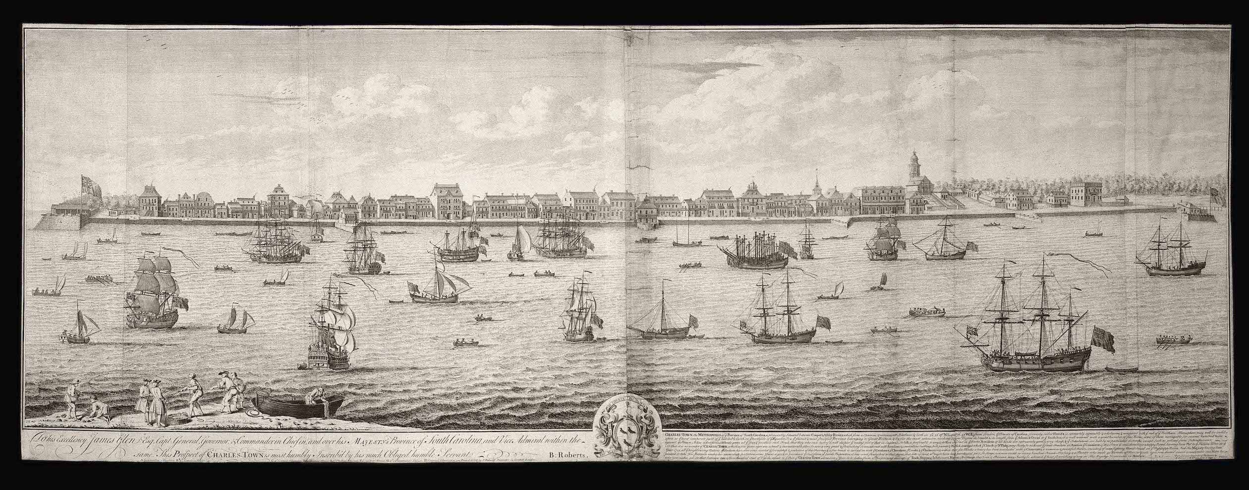
East Bay Street is one of Charleston’s most scenic and popular thoroughfares, home to numerous shops, restaurants, and historic buildings that contribute greatly to the city’s charm. Running parallel to the Cooper River waterfront, East Bay Street was for three centuries the main artery for the traffic of goods and people moving between the town and the commercial wharves that once projected into the river. Most of that maritime infrastructure is now gone, however, and a swath of firm real estate averaging one-eighth of a mile wide separates the historic street from the water’s edge. This volume of accumulated earth and human construction obscures the street’s distant past, but physical evidence of its humble origins survive just beneath the surface.
The historic core of East Bay Street, spanning from Market Street southward to the northern end of the High Battery, was created nearly 350 years ago in the early days of the Carolina colony. Long before long wooden wharves projected far into the Cooper River to receive cargo from incoming ships, East Bay street was simply an exposed riverbank just above the line of high water marked by the daily fluctuation of the tides. To visualize its original appearance and to better understand its transformation into the landscape we see today, we need to point our imaginations back in time to the earliest days of the Palmetto City.
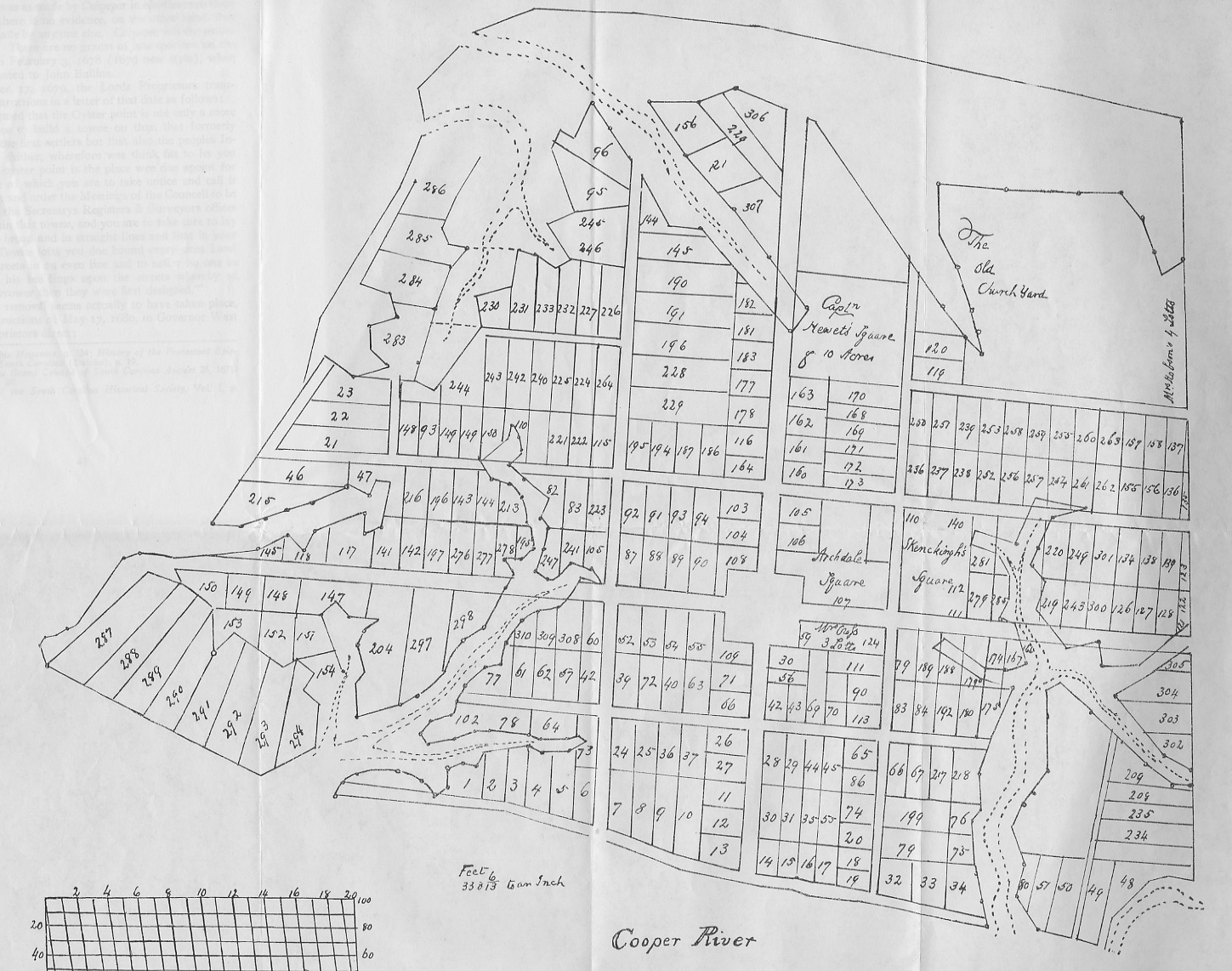
The peninsula between the Ashley and Cooper Rivers was originally called Oyster Point by the earliest European settlers of the Carolina Colony, who in 1670 established their capital, Charles Town, at Albemarle Point (now Charles Towne Landing State Historic Site). A handful of people settled at Oyster Point in the early 1670s, however, and the government recognized that the peninsula might be a convenient location for a town. In the summer of 1672, the governor ordered the surveyor general of the colony to draft a plan for a new town at Oyster Point and stake out the plan on the ground. The surveyor’s plan, called the “Grand Model,” divided the southern part of the peninsula into just over three hundred building lots and eleven streets. The easternmost of these streets, adjacent and parallel to the Cooper River, is what we now call East Bay Street, although it lacked a proper name for many years.[1]
Mathews described the waterfront area immediately to the east of this “publick wharfe” as “a clean landing the whole length of the town.” Ships anchoring before the town would be safe in any weather, he said, “for no wind can blow so great . . . as to hurt a vessell [sic] upon the soft sand or oaze [ooze].” At the southern end of the peninsula, Mathews noted, “ships may also grate upon the point [that is, White Point] with much ease and safety.” In its natural state at the founding of Charleston, therefore, the town’s entire eastern waterfront was bounded by an extensive mudflat free of rocks and other dangerous obstructions.[2]
The population of new Charles Town and its maritime traffic expanded rapidly after the capital moved to the peninsula in 1680. Shipping was the lifeblood of the nascent colony, connecting South Carolina to distant ports in England and the Caribbean. Descriptions of life within the new capital of South Carolina from the 1680s are now exceedingly scarce, however, rendering it difficult for modern Charlestonians to imagine the initial condition of the town’s eastern waterfront along the Cooper River. Fortunately, the recently discovered, hand-drawn map of Charleston, ostensibly made in the spring of 1686 by French immigrant Jean Boyd, provides a valuable visual depiction of the small town that was mostly clustered near the Cooper River and south of Broad Street (see Episode No. 98).
Today we know East Bay Street as a land-locked thoroughfare that’s disconnected from the waters of the Cooper River. In order to visualize this historic street as a long, narrow wharf—the nexus of all commerce in early South Carolina—we have to use our imaginations, supplemented by a knowledge of maritime traditions, to construct a mental image of the early appearance of Charleston’s first wharf and the logistics of its commercial activities.

Charleston’s original wharf was, therefore, simply a long, narrow bank along the edge of the high-water mark and adjacent to a tidal mudflat of the Cooper River. So how did the town’s early settlers transport cargo across the muddy landscape between ship and shore? Prior to early years of the eighteenth century, when investors began building wooden piers extending eastward into the river, Charlestonians employed traditional practices familiar to mariners around the world. Small sailing vessels and row boats, especially the canoes, periaugers, and small schooners carrying goods from nearby plantations, could anchor close to the wharf at high tide and then rest among the cordgrass at low tide. A human chain of salty crewmen could then stand in the pluff mud and hand the cargo up to the wharf.
This simple practice was not appropriate for larger sailing vessels, however, which needed to anchor in waters at least three or four fathoms (18–24 feet) deep. During Charleston’s early years, such depths were found approximately 600 to 1,000 feet to the east of the wharf we now call East Bay Street. To bridge the distance between these points, mariners used a variety of smaller watercraft to ferry cargo between ship and shore. Descriptions of this logistical practice are lacking among the sparse paper records of early South Carolina, but it was an ancient phenomenon common to port communities around the world. Shallow-draft, flat-bottomed barges, generically called “lighters” in England, would float alongside larger vessels to receive cargo, ballast, or passengers, and then row to shore to unload at (or at least close to) the wharf. The use of lighters must have been such a common practice in early Charleston that it did not merit description in written records, although extant government documents include information about the use of lighters to transport ballast around the harbor in the early eighteenth century.[4]
The transformation of Charleston’s first wharf into the thoroughfare we call East Bay Street was a slow process of both human engineering and natural accretion. This work formally began in the late 1690s, but conversations about the need to “shore up,” “wharf-in,” or otherwise protect the waterfront face of the town’s wharf commenced in the late 1680s. Not surprisingly, the earliest-known discussions of this topic followed in the wake of a hurricane. In August 1686, a Spanish invasion force moving northward from St. Augustine raided homes and plantations across Port Royal, Edisto, and Wadmalaw Islands, but the sudden appearance of a destructive hurricane forced the invaders to retreat back to Florida.[5] The same storm that saved Charleston from attack in 1686 apparently caused a tidal storm surge that also damaged the capital’s earthen wharf. Waterfront erosion was probably not a new phenomenon at this location, but the damage resulting from the hurricane of 1686 was sufficient to warrant an appeal to the Lords Proprietors— the English investors who owned the entire colony.
Whatever the language Governor Colleton employed to solicit a concession from the Lords Proprietors, his plan succeeded. The Proprietors responded in October 1687 with the following brief but important statement: “We take notice that you write that ye wharfe at Charles Towne weares away and if not prevented will undermine the houses[.] We are willing [to concede that] the respective inhabitants should have liberty to wharfe in[,] each man before his owne house[,] and enjoy it to his owne use[,] provided that amongst them they wharfe in that part alsoe that is against the ends of the streets that open upon the river and keep it in constant repaire.”[6]
This relatively terse property concession might not sound very significant, but it provided the spark that initiated the transformation of Charleston’s waterfront into the landscape we see today. To clarify its meaning, I’ll try to rephrase the original text using more robust language. The Lords Proprietors said that each of the owners of the nineteen town lots fronting the wharf of Charleston could claim ownership of the tidal mudflat opposite his or her respective lot, to the east of the town wharf and down to the low water mark, if they and the provincial government agreed to adopt two long-term responsibilities. First, each property owner on the west side of the wharf would be obliged to build and maintain a permanent revetment or seawall on the east side of the wharf corresponding to the breadth of his or her respective town lot. Second, the citizens in general, through their provincial government, would be responsible for building and maintaining similar revetments at the east end of Broad, Tradd, and Queen Streets that “open upon the river.”
The waterfront concession offered by the Lords Proprietors in October 1687 might have triggered a fast-moving story about the advance of private commercial enterprise in the port of Charleston, but political infighting derailed the narrative for more than six years. By the time the Proprietors’ letter arrived in Charleston at the end of 1687, South Carolina’s provincial government had descended into a state of dysfunctional paralysis. The eruption of political disagreements within the legislature induced Governor James Colleton to dissolve the parliament and, later, to proclaim martial law in the colony. Seth Sothell, the owner of a share in the Carolina proprietorship, claimed the governor’s office when he came to Charleston in late 1690 and ruled over an illegitimate government for a year and a half. The arrival of legitimate Governor Philip Ludwell in the spring of 1692 brought renewed stability to the colony, but the continuation of factional disputes within the newly-reorganized legislature undermined his authority. In short, the persistence of political dysfunction in South Carolina between 1687 and 1693 prevented the provincial government from addressing the continuing erosion of Charleston’s sole wharf.[7]
On the last day of a brief legislative session in May 1693, the South Carolina Commons House of Assembly briefly considered a bill for “wharfeing in ye banke at Charles Town.” After committing the bill to the care of Representative Robert Gibbes, the assembly promptly adjourned for the summer without taking any action on the subject. In the meantime, Governor Philip Ludwell departed the fractious colony and Landgrave Thomas Smith officially became governor in the autumn of 1693.[8]

Accordingly, the Proprietors ordered “that every man that hath a lott on ye sea shall have liberty to wharfe in ye land before his lott in ye s[ai]d towne, and take a profit of it to himselfe[;] provided that ye persons who have ye benefit of this our concession doe settle some way amongst them, for the wharfing and keeping in constant repaire ye wharfes ag[ains]t ye ends of ye streets[;] also soe that there may be a [public] wharf for ye other inhabitants to land their goods at without charge.”[9]
Shortly after receiving this news from the Lords Proprietors, the South Carolina legislature began formulating an immediate plan for the preservation of the wharf of Charleston. It’s unclear whether they simply revised the bill that had been left with Colonel Gibbes the previous year or drafted a new bill from scratch, but, in either case, they moved quickly. On June 20th, 1694, the provincial assembly ratified “An Act to prevent the Sea’s further encroachment upon the Wharf at Charles Town.”[10]
The text of this landmark law is not extant, unfortunately, but several of its clauses were quoted and summarized in later government documents. From a committee report submitted to the Commons House of Assembly in 1739, for example, we know that the “wharf act” of 1694 ordered the construction of a brick wall to extend approximately 2,700 feet along the entire length of the town’s wharf. More specifically, the wall was to extend “from the southernmost side of Capt. Bennet’s lot” (the southeast corner of town lot No. 1, now in front of No. 43 East Bay Street) “to the northwardmost side of Major Robt. Daniel’s lot” (the northeast corner of town lot No. 34, now in front of No. 215 East Bay Street). Each of the individual owners of the nineteen lots and subdivisions of lots on the west side of that line (lot numbers 1–10, 13–17, 19, 32–34 in the Grand Model) was obliged to build a portion of the brick wall along on the east side of the wharf that corresponded to the breadth of his or her property.[11]
The original descriptions of the height, width, and other details of the brick wall proposed in 1694 are now lost. The aforementioned 1739 summary simply stated that each of the respective property owners was “obliged to build a brick wall three feet thick.” Property owners who signed a bond after the ratification of the act (20 June 1694), promising to complete their respective portion of the wall within eighteen months, would be “entitled to a grant for the low water land lying before the wall so directed to be built.” Beyond soliciting these individual promises to begin building portions of the wall, however, the 1694 law apparently did not impose a construction timetable or attempt to coordinate the efforts of the respective property owners.[12]
The “wharf act” of June 1694 appointed several commissioners to oversee the work, but there are no surviving records of any individuals completing any work on this project in 1694 or 1695, and no low-water lots were granted to the owners of lots on the west side of the wharf during that time. This lack of evidence does not necessarily mean that the owners of waterfront property were shirking their duty to shore up the wharf’s eastern face. The text of a government review of the project, undertaken in the spring of 1696, shows that an unspecified number of property owners had submitted bonds to the government, but none had yet completed their respective portions of the wall. In fact, there’s no evidence that any of them had even broken ground by that time.
Twenty-one months after creating the “wharf act” of 1694, the South Carolina assembly passed a revised version of the law that survives in manuscript form. That document, along with more than a dozen subsequent legislative revisions and additions spanning from 1696 to 1764, provides copious details about the dimensions, materials, and location of Charleston’s first “wharf wall,” as it became known. On March 16th, 1696, for example, we know that the provincial government ordered the commissioners of the wharf wall, within ten days, to “cause to be surveyed laid out and staked with sufficient ceader [sic] stakes the line upon which the wall mentioned in the said act is to be built.”[13]
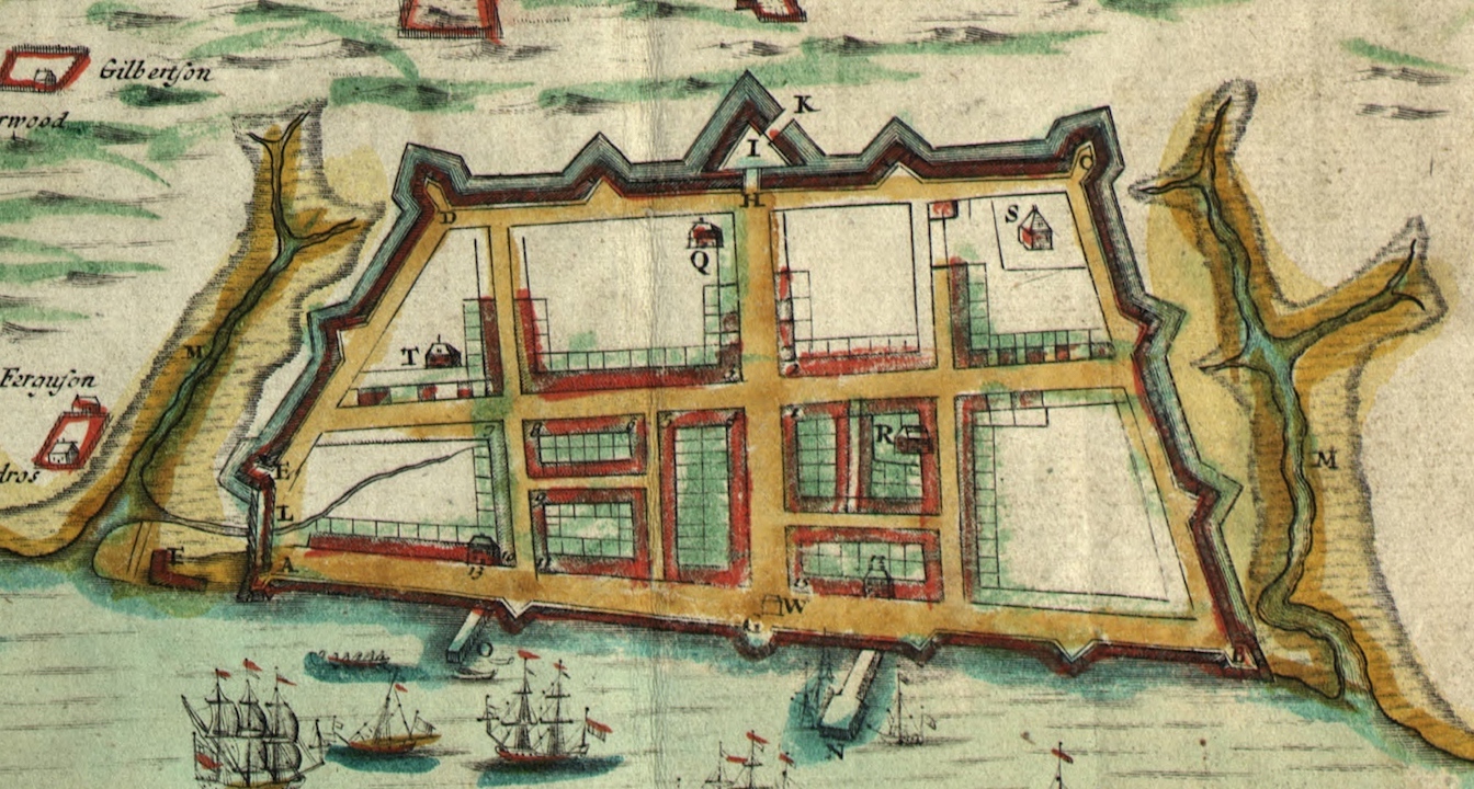
Construction of Charleston’s first seawall definitely commenced sometime after the spring of 1696, but I’m going to postpone further discussion of this project for the moment. The story continues without interruption for another century, but it was subsumed into another narrative around the turn of the eighteenth century. Government discussions of the brick wharf wall after 1696 were couched within a larger conversation about the construction of urban fortifications, and by 1702 the seawall was described as a component in an expanding chain of defensive works. We’ll return to this story, therefore, in a discussion about the construction of Charleston’s earliest permanent fortifications.
To conclude the present conversation, however, I’ll offer a brief resumé of the civic and commercial history of Charleston’s first wharf that became East Bay Street. Beginning in the spring of 1698 and continuing for several subsequent years, South Carolina’s provincial government granted a number of low-water lots on the east side of East Bay Street to the owners of the various lots on the west side of the street. This fact confirms that multiple segments of the wall were standing by the end of the seventeenth century, though its completion required several more years of work. Starting after 1698, when private individuals began acquiring titles to portions of the tidal mudflat to the east of the town wharf, the most ambitious of these new owners built wooden piers projecting at perpendicular angles away from the original wharf. These wooden structures, called “bridges” in the early eighteenth century, extended eastward into deeper water and enabled larger vessels to dock and unload their cargo directly onto the wooden platforms.

Speaking of East Bay Street, let’s add a brief word about the name of this historic street. As we all now know, the street was originally described as a wharf in the 1680s. By 1696, if not earlier, Charlestonians were using a new name to describe their waterfront. A law ratified on March 16th of that year described the town wharf as “the bay of Charles Towne.”[14] That rather generic term, “the Bay,” referring to the street and not the water, persisted as the standard designation for Charleston’s waterfront thoroughfare for the remainder of the colonial era. The phrase “Bay Street” appears occasionally among extant records dating from the 1730s onward, but it was not in common use until the last quarter of the eighteenth century. The phrases “East Bay” and “East Bay Street” first appeared in local newspapers and other records created after the American Revolution. By the turn of the nineteenth century, they had become the standard designations that we still use today.
The next time you’re on East Bay Street, I invite you to take a moment to pause at the southeast corner of its intersection with Tradd Street. There you’ll see a display installed several years ago by the City of Charleston and the Mayor’s Walled City Task Force to explain and illustrate the history of colonial-era fortifications at that site. While viewing that display, you’ll learn that you’re standing on a portion of Charleston’s original wharf wall, the foundations of which remain buried under the modern streetscape on the east side of East Bay Street. All of this information forms a virtual time machine, allowing you to look beyond the asphalt and concrete at your feet to see the vast tidal mudflat that once formed Charleston’s original waterfront.
[1] For more information about the Grand Model, see Henry A. M. Smith, “Charleston: The Original Plan and the Earliest Settlers,” South Carolina Historical and Genealogical Magazine 9 (January 1908): 12–27.
[2] Samuel G. Stoney, ed., “A Contemporary view of Carolina in 1680,” South Carolina Historical Magazine 55 (July 1954): 154. The original source of this item is an undated manuscript “Coppie of a Letter from Charles Towne in Carolina,” located at Edinburgh University Library, Special Collections, Laing Collection, La. II, 718/1.
[3] For more information about the history of tidal inundation on the Charleston peninsula, see Christina Rae Butler, Lowcountry at High Tide: A History of Flooding, Drainage, and Reclamation in Charleston, South Carolina (Columbia: University of South Carolina Press, 2020).
[4] The use of lighters to move ballast is mentioned, for example, in “An Act for the better regulating the Port and Harbour of Charles Town and the Shipping frequenting the same,” ratified on 9 April 1734. The text of this act was not included in the nineteenth-century published compilation of The Statutes at Large of South Carolina, but the engrossed manuscript survives at SCDAH. An “abstract” of the act appears in South Carolina Gazette, 6–13 July 1734. A “ballast master” continued in Charleston harbor at least to the 1770s.
[5] For an over view of the 1686 Spanish raid, see Lawrence S. Rowland, et al., The History of Beaufort County, South Carolina, Volume 1, 1514–1861 (Columbia: University of South Carolina Press, 1996), 67–75. For a contemporary description, see J. G. Dunlop and Mabel L. Webber, eds., “Spanish Depredations, 1686,” South Carolina Historical and Genealogical Magazine 30 (April 1929): 81–89.
[6] Lords Proprietors to Governor James Colleton, 10 October 1687, in Colonial Entry Book Vol. 22, p. 121, published in A. S. Salley Jr., indexer, Records in the British Public Record Office Relating to South Carolina 1685–1690 (Atlanta: Foote and Davies for the Historical Commission of South Carolina, 1929), 227. Spelling original.
[7] For a description of the political situation in South Carolina between 1687 and 1693, see M. Eugene Sirmans, Colonial South Carolina: A Political History, 1663–1763 (Chapel Hill: University of North Carolina Press, 1966), 35–54.
[8] A. S. Salley, Jr., ed., Journals of the Commons House of Assembly of South Carolina for the Four Sessions of 1693 (Columbia, S.C.: The State Company for the Historical Commission of South Carolina, 1907), 25, 26.
[9] Lords Proprietors to their deputies at Charleston, 24 April 1694, in BPRO, Board of Trade, Carolina records, Vol. 4, pp. 13–14, published by A. S. Salley Jr., indexer, Records in the British Public Record Office Relating to South Carolina 1691–1697 (Atlanta: Foote and Davies for the Historical Commission of South Carolina, 1931), 119–23.
[10] Thomas Cooper, ed., The Statutes at Large of South Carolina, volume 2 (Columbia, S.C.: A. S. Johnston, 1837), 81, assigned the number 110 to this act and identified its date as 16 June 1694, but subsequent revisions of this law, and later compilations of statute law published by Nicholas Trott in 1736 and John F. Grimke in 1790, as well as a report presented to the Commons House of Assembly in 1739, all cite the date as 20 June 1694.
[11] For a brief summary of the chain-of-title for these nineteen wharf-adjacent lots, which the provincial government granted to individuals between 1678 and 1695, see Susan Baldwin Bates and Cheves Leland, eds., Proprietary Records of South Carolina, Volume Three: Abstracts of the Records of the Surveyor General of the Province, Charles Towne 1678–1698 (Charleston, S.C.: History Press, 2007), 113–27.
[12] See the text of Act No. 131 in Episode No. 181, and the committee report debated by the Commons House on 15 March 1738/9, in J. H. Easterby, ed., Journal of the Commons House of Assembly November 10, 1736–June 7, 1739, 669–71.
[13] See the third section of Act No. 133, “An Act to Appropriate the Moneys Raised and to be Raised by an Imposition on Liquors, &c. Imported into, and Skinns and ffurrs Exported out of this Part of this Province to a ffortification in Charles Town,” ratified on 16 March 1695/6. Part of the text of this act is reproduced in David J. McCord, ed., The Statutes at Large of South Carolina, volume 7 (Columbia, S.C.: A. S. Johnston, 1840), 6–7, but the complete text is found at SCDAH, General Assembly, Acts, Bills, and Joint Resolutions, vol. 6: Book of Acts from 1696 (“Governor Archdale’s Lawes”), 84–87.
[14] The quoted phrase, extracted from the aforementioned Act No. 133, appears in McCord, Statutes at Large, 7: 6.
NEXT: Planning Charleston’s First “Fortress,” 1695–1696
PREVIOUSLY: Charleston’s Contested Election of 1868
See more from Charleston Time Machine