Today we’re going to continue on journey we started in our last episode, looking back at notable hurricanes that have made an impact on the Lowcountry over the past few centuries. We left off at the turn of the nineteenth century, when relatively modest-sized hurricanes in 1797 and 1800 caused significant damage to an important landmark in downtown Charleston—a new seawall that protected the southward extension of East Bay Street. The landmark we now call the “high battery,” and the roadway behind it, which we call East Battery Street, were then new, very expensive construction projects in the late 1790s, but the tropical gales of 1797 and 1800 brought powerful waves that undermined and over-washed the unfinished work. Lots of expensive repairs were required, and Charleston was set to have a beautiful promenade overlooking the harbor. But Charleston was also long overdue for a powerful hurricane. On the 7th, 8th, and 9th of September 1804, Mother Nature called again with the strongest storm to his Charleston since the massive storm of 1752. Let’s listen to a few descriptions from the newspapers of 1804 Charleston:
“A storm which it is said has not been equaled within the memory of any citizen of Charleston, commenced on Friday evening last, accompanied with very high wind from the North-East, and continued without any considerable abatement, till one o’clock [Sunday] morning. . . . There is not a wharf in the city that has not experienced the dreadful effects of the storm, and some to a very great degree. Many buildings were thrown down, and many others much injured; some of the streets were covered with the slate and tile which were torn from the roofs of the houses; great numbers of the trees which ornamented the city, are destroyed, and the havoc generally made is almost beyond description.”[1]
“New East Bay Street, which, since the gale in October 1800, has been repaired at a great expense, is again destroyed; the sea made clear breaches through it, and rushing into Water-street, and the adjacent parts, compelled the inhabitants to quit their houses, in the lower stories of some of which the water was 14 inches deep. In this part of the city, we state from actual observation, that the tide rose three feet higher than it has ever been known since the hurricane of 1752; and several feet higher than the usual spring tides—the whole of Water-street was covered, and in Meeting-street it was nearly two feet in depth.”
“The whole of [South Bay Street] from Meeting-street to McKenzie’s wharf [, near Legare Street,] is washed away. . . . The tide rose so high, that most of the inhabitants quit their houses, and took shelter in a more central part of the city—Two or three small coasting vessels were here driven to pieces. . . . In the vicinity of the city, the gardens have sustained considerable injury—the fences were blown down—large trees torn up by the roots; and the vegetation appears blasted by the salt spray. . . . But few lives were lost in the gale.”[2]
“Great apprehensions were entertained for the safety of the families on Sullivan’s Island, but accounts received from thence yesterday, were very favorable, not a life was lost there except a black boy. From fifteen to twenty houses were undermined by the water and washed away; the inhabitants of which lost almost everything that was in them. It is the opinion of some gentlemen who were on the island and who came up yesterday, that if the water had continued to rise for half an hour longer, scarcely a house would have escaped and many people must have perished.”[3]
Following the devastating hurricane of 1804, we again had a bit of a dry spell for several years. In late August 1813, a modest hurricane hit Charleston and caused a moderate amount of damage to the city. The most significant casualty in the 1813 storm was the brand new wooden bridge connecting the peninsula with the parish of St. Andrew’s—what we now call West Ashley. That first bridge across the Ashley River represented an investment of approximately $100,000 at the time, and it wasn’t rebuilt until the mid-1850s.
Nearly a decade later, in late September 1822, another hurricane brushed past Charleston. The eye of the storm actually made landfall near Bull’s Bay, and the area around the Santee River delta bore the brunt of the storm’s fury. Dozens—perhaps hundreds—of enslaved people were drown in and around the extensive rice fields of the Santee delta, as the storm surge inundated the low, swampy region. In the aftermath of the storm many planters in the delta erected storm towers—low, circular brick towers with elevated floors—as a means of providing emergency shelter for the enslaved people working in the rice fields. A few of these storm towers still exist, and are protected by the National Register of Historic Places. Meanwhile, back in Charleston, the hurricane of 1822 passed the city at low tide, so flooding was minimal. The worst of the winds hit the area north of the Santee River, but in Charleston the topmost part of St. Philip’s steeple was toppled, and the weather vane atop St. Michael’s Church was bent by the force of the wind.[4]
In the three decades after the hurricane of 1822, the South Carolina Lowcountry witnessed the arrival of a number of tropical storms and mild hurricanes. The hurricanes of 1824, 1834, 1835, 1837, and 1846 were the most notable of this era, but they were not very memorable, and so we have very little detailed information about them. This situation changed in the 1850s, however, when the science of meteorology became more established in the United States. From that time to the present, we have an unbroken collection of scientific data that allows us to reconstruct, to a certain degree, the path and the strength of historic hurricanes.
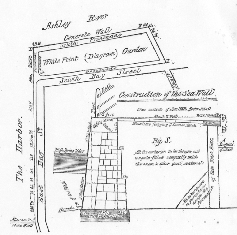
An image of the 1855 Parker Survey of the Battery seawall.
The first storm to impact South Carolina in this new era was the massive hurricane of early September 1854, which became known as the “Great Carolina Hurricane.” The storm actually made landfall just south of Savannah as what we would now call a Category 3 storm, using the modern Saffir-Simpson hurricane wind scale. The hurricane then cut northward across South Carolina, gradually decreasing in strength as it passed Beaufort and Charleston, heading towards Columbia and then Cheraw. Thomas Chaplin, a planter in Beaufort County, described the event as a “tremendous gale. . . trees & limbs flying in every direction. . . . I never saw such a storm in my life. Crops are all ruined. The water is two feet deep in my yard. . . . cotton, corn and potatoes were underwater.”
Edisto Island also suffered both strong winds and a powerful storm surge in the 1854 hurricane. The winds in the upper part of Charleston county, however, were a bit weaker, in the range of a Category 1 cyclone, bringing relatively little damage. Instead, a Category-2 strength storm surge coming at high tide caused havoc downtown, in Mt. Pleasant, and on Sullivan’s Island. Many beach-front homes were either swept away or blown down, and the inhabitants fled for their lives. One eye-witness remarked that the character and general aspect of the island had been “essentially changed” by the storm. The former shoreline, dunes, and embankments had all been washed away, or rather moved to new locations. The storm surge was reported to have been approximately nine and a half feet higher than at the normal spring tides.[5]
On the Charleston peninsula, the worst of the damage occurred along the Battery seawall, which had been finally completed in 1818, and at White Point Garden at the southern tip of the peninsula. Here the waves washed over the battery, undermined large parts of the stone wall, and flooded the entire neighborhood. If you walk down the southernmost end of East Battery Street in Charleston today, you’ll notice that the high battery sea wall is, well, pretty high above the level of the street. But it wasn’t always so. In fact, when the granite Battery sea wall was first completed in 1818, it was just two or three feet above the level of the street. After the damage caused by the hurricane of 1854, however, the city invested in an extensive project to repair the wall and to raise it another couple of feet. Thus when you walk along the historic high battery today, you’re actually walking atop the post-1854 elevation of the wall.[6]
During the Civil War, we saw very little hurricane activity in South Carolina, which is just as well, because we had plenty of other dangers and disasters on our collective plate. After the war, we narrowly missed being struck by passing tropical storms in 1865 and 1867. Then, in late September 1874, a category 2 storm hit the Lowcountry. Most people haven’t heard of the hurricane of 1874, but it was definitely a memorable storm. The winds and storm surge of this Category 2 storm caused damage, to be sure, but the local media focused on the damage to the Battery, which had only recently been repaired, and the loss of a wooden structure called the Bathing House, a sort of wooden island on stilts in the Ashley River, one hundred feet south of White Point Garden. Let’s listen to excerpts from the coverage in the Charleston News and Courier, from late September 1874:
“The scene on the Battery, while the gale was at its height, was at once sublime and terrible. The sea wall promenade on East Battery, which on Saturday night last was thronged with promenaders, was almost entirely submerged. The angry waves dashed over the stones in huge billows and flooded the street below, tearing up the huge flagstones and washing away the shell road. On South Battery the destruction was equally sudden and terrible. The water poured in volumes over the abutment, and long before eight o’clock was fully two feet deep in the lawn of White Point Garden. The beautiful Battery is now a scene of ruin, and it is calculated that it will take at least twenty thousand dollars to repair the damage done at this point alone.
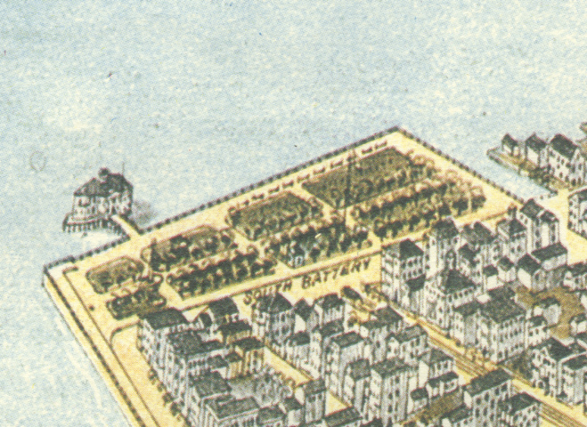
An 1872 bird's eye view map of the Battery with the Bathing House in place.
At nine o’clock a messenger arrived at the Main Guardhouse with the news that the frail bridge, leading to the Bathing-house, had been swept away, and that the Bathing-house itself, with its owner and his family, who were in it, were in imminent peril. The news spread like wildfire, and in a short time hundreds of excited spectators had assembled on the Battery to satisfy themselves as to the truth of the report. The gale at this time (ten o’clock) was absolutely furious; a terrible hurricane, hurling huge masses of water over the high Battery and rolling huge breakers breast-high along the south walk. The garden was fully four feet under water, presenting a clear sheet from East to South Battery. But all eyes were turned from the scene of devastation immediately around them to a point of more thrilling interest. The Bathing-house, cut off as it was from all communication with the land, was rocking on its foundation, and it was at once seen that every effort must be made, without delay, to rescue the unfortunate inmates. These were Mr. McMannon, his wife and two children, and a young man who occupied one of the rooms.”
There follows a long heroic story of their rescue, but I’ll save that for another program. Meanwhile, back to the newspaper:
“At Moreland’s wharf on South Bay, what remained of the pier heads there, with the shanties and boat houses thereon, were undermined, and the most of them fell in ruins. The fishermen’s boats were driven from their moorings, west of the Battery, and left high and dry some distance in King street. The rest of the residences on South Battery were completely overflowed, and the fences and outhouses either overturned or damaged by the surging mass of water.”[7]
The saddest scene of all, however, was the magnificent sea wall on East Battery, now a mass of crumbling ruins. So violent was the force of the wind and waves that the huge paving stones with which East Battery was laid were taken up and hurled into the streets. The entire promenade is destroyed. In some places the walk was undermined by the waves and caved in. In other places it was completely washed away, the brick support on the street side being thrown down. The damage to the south walk is almost as great. The concrete wall of which this is formed was not so exposed as the stone wall on East Battery, and it therefore did not suffer as much. But the action of the water made deep ruts and holes in the shelled walk, and rendered it almost impassable. The grass on the sward [sic] too has a wilted appearance from being covered with water, and many of the granite posts and rails were swept away.
Nothing remains of the Bathing-house save a rickety crumbling ruin and the stumps of the posts upon which it was built. Over two-thirds of the building was carried away in the storm, and the remaining portion has fallen out of position, and lies heaped up on the half-sunken foundations. A tolerably stiff breeze or a strong tide will carry away the last vestige of this favorite resort. It is hard to estimate the loss sustained by the city in the destruction of East Battery, but it will hardly cost less than $20,000 to $25,000 to restore it. The loss to Mr. McMannon, the owner of the Bathing-house, is particularly severe, as he had just spent a large sum of money in putting repairs upon it. It is not likely soon to be rebuilt; so that landmark of Charleston may be considered as gone. What action the City Council will take towards rebuilding the Battery is not yet known; but the hope is generally expressed that the work will be commenced at once. During the entire day the ruins were crowded with curious people, men, women and children, gazing at the terrible work of the storm, and wondering how it all could have happened.”[8]
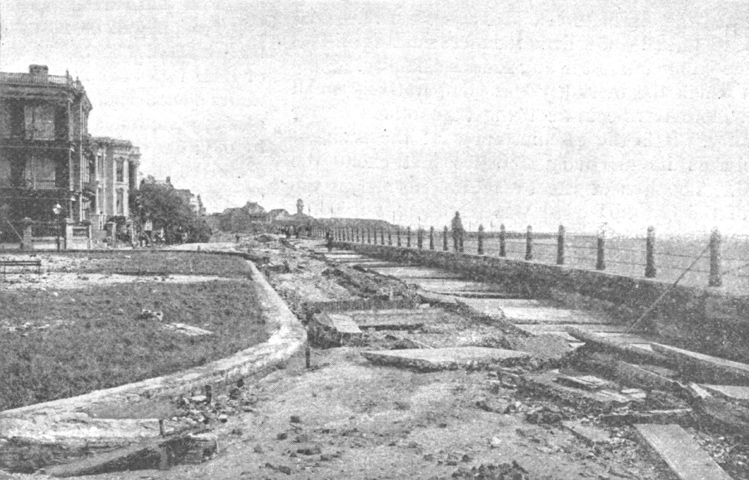
Damage on South Battery after the hurricane of 1885.
The next strong hurricane to hit Charleston, in late August 1885, has been classified by recent weather historians as a weak Category 2, and the eye of the storm appears to have passed over the city itself. The high water mark was nearly identical to that of 1854, and so the battery seawall again suffered extensive damage. The Bathing house, destroyed in the hurricane of 1874 and rebuilt at great expense, was again smashed into the Ashley River and never revived. Eye witnesses reported that most of the city’s perimeter was completely underwater in late August 1885, and that boats could be rowed from place to place through many of the streets. The water rushing up Water Street, from the bay to Meeting Street, was said to be rushing “at the speed of a millrace.”[9] In the Charleston area, more than a hundred people perished, most from drowning in swollen rivers and along the coastline.
As sad as that is, the casualties were far greater in the massive hurricane that arrived here in late August 1893. The “Great Sea Island Storm” of 1893 is so named because the coastal sea islands of Georgia and South Carolina bore the brunt of the violence. It has been estimated that between 2,000 and 3,000 people, most of them poor African-Americans, drown in this tragic event. The storm made landfall near Savannah as a Category 3 hurricane, and most of the damage caused by high winds and storm surge was concentrated in the area around Beaufort, South Carolina. The waters rose up so fast that many people drown in their beds, unaware of the approaching danger. The human toll, as well as property damage, caused by the 1893 hurricane was long remembered in the Beaufort and Edisto area. Many folks never forgot the day when it seemed like a mountain of ocean suddenly rushed in and destroyed their lives. There was storm damage in the Charleston area, to be sure, but it was trivial compared the devastation witnessed on the sea islands to the south.
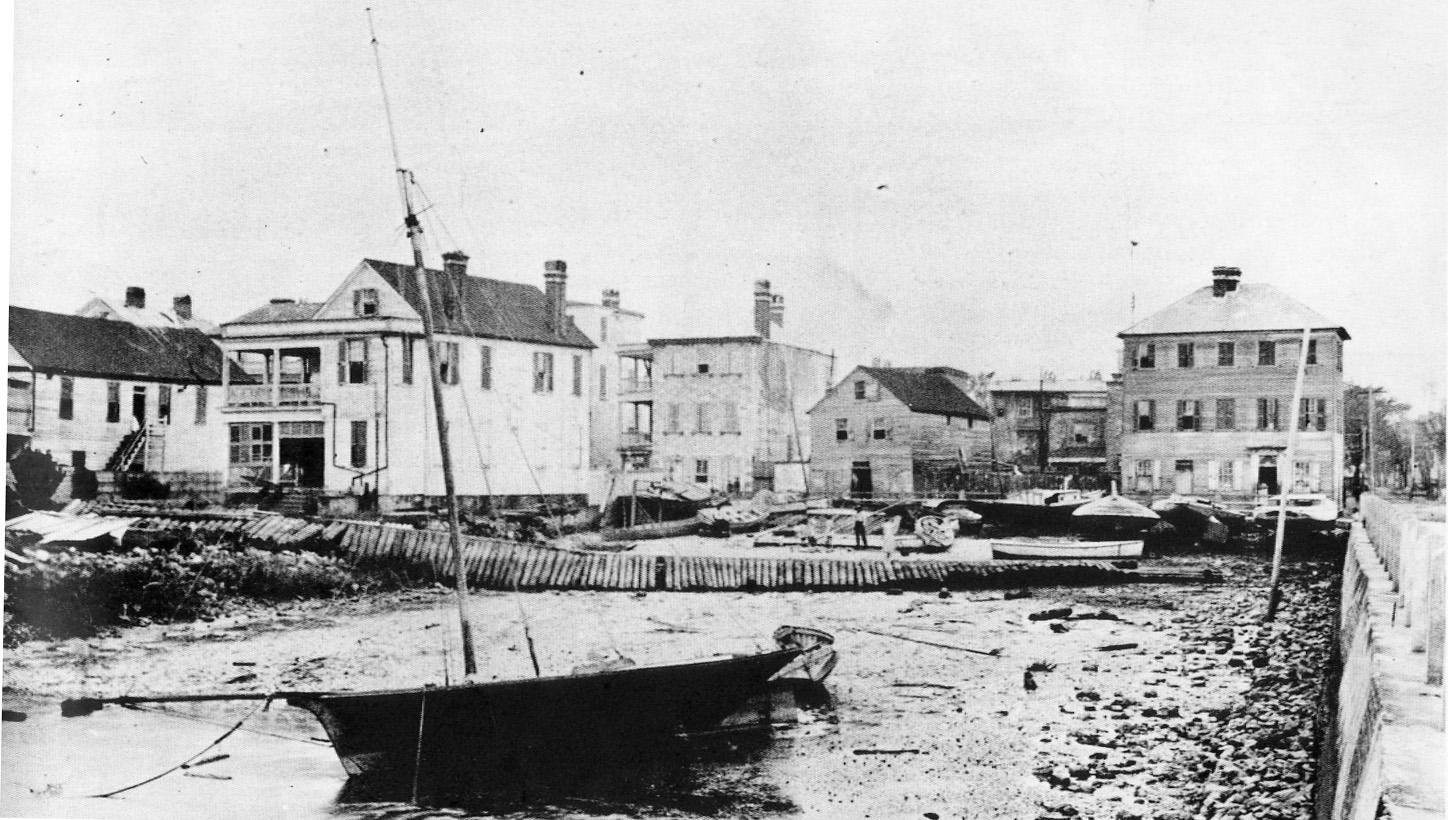
An image of the Battery after a hurricane in an 1893 edition of Harper's Weekly Magazine.
A noteworthy feature of the great hurricane of 1893 was a novel piece of technology. Two days before the storm struck our coastline, the National Weather Bureau in Washington D.C. issued a telegraphic bulletin, advising that their data indicated that a large storm appeared to be moving across the Atlantic Ocean, about 500 miles east of Florida. Harbor masters across the southeast hoisted red storm pennants, and many people close to the coastline had some semblance of advanced warning.[10]
With this advance in science and communication, the public threat caused by hurricanes began to diminish. Although we humans currently lack the power to diffuse a hurricane, our ability to prepare for its arrival, or to move out of its path, represents a huge step forward in safety. Thus by the turn of the twentieth century, we finally achieved some measure of defense against these marauding natural phenomena. In all subsequent storms, most of the population had advanced knowledge of the threat, and were able to batten down the hatches, literally and figuratively, stow their valuables, and evacuate their families. But the improvements in communication were not perfect.
In late August 1911, for example, a powerful hurricane caused the usual flooding and high winds in the Lowcountry, but public officials did not adequately inform the public of the coming threat. As a result, many folks who should have evacuated were drown in their own homes. The 1911 storm surge completely swept over Sullivan’s island, and as many as a hundred people drown on that island alone. Incidentally, this was also the storm that inspired the hurricane scene in Dubose Heyward’s 1925 novel, Porgy, which George Gershwin transformed into the opera, Porgy and Bess. In the aftermath of the 1911 storm, South Carolina was forever changed. Our commercial rice industry, which had been in decline since 1865, was completely undone. And henceforth, public officials began to take more seriously the duty of alerting citizens of the threats posed by approaching storms. The hurricane of 1911 is also one of the first to have been amply recorded in photographs, and local institutions such as the Charleston Museum and the South Carolina Historical Society have some wonderful images of the 1911 storm damage.[11]
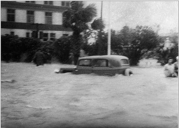
A car underwater at White Point Gardens in 1940.
The same can also be said for the Category 1 hurricane of August 11th 1940, which completely flooded White Point Garden and all the riverfront streets of Charleston. The hurricane of 1940 has no name, but a few years later, in the mid-1940s, the National Weather Service began using personal names to identify hurricanes, in an effort to facilitate discussion and comparison of historical storms. In 1951 the United States government adopted a new radiotelephony spelling alphabet, using a word to represent the letters of the alphabet for radio transmission (Able, Baker, Charlie, etc.). In that same year, the national weather service started using that same radiotelephony spelling alphabet to name the annual succession of tropical cyclones. Two years later, in 1953, however, the United States adopted a revised international radiotelephony spelling alphabet—the one that begins with the words Alpha, Bravo, Charlie, Delta, Echo, etc. Following this change in nomenclature, our National Weather Service began using female names, in alphabetical order, for hurricanes.
Thus the next major storm to hit the Charleston area was Hurricane Gracie, a Category 3 storm that arrived in late September 1959. Gracie hit our coastline at low tide with a relatively small storm surge, but her winds caused a considerable amount of property damage. Hurricane Donna, a relatively small hurricane that blew across the Lowcountry in September 1960, did relatively little damage, but it’s worth noting that Donna’s winds spawned a tornado that did significant damage to Bennett’s Rice Mill on the Cooper River waterfront, facing Washington Street. Today you can see the brick façade of Bennett’s rice mill standing behind the Harris Teeter grocery store, but there was much more of that brick structure standing before Hurricane Donna threw it down in 1960.
The next storm worth mentioning is Hurricane David, a storm that made landfall in Florida as a Category 3 and degraded into a Category 1 storm by the time it passed over Charleston in early September 1979. Although David didn’t cause much damage in the Lowcountry, it’s noteworthy because the 1979 season was the first year that the National Weather Service applied male names to hurricanes, alternating with female names in alphabetical order.
Ten years later, when the season’s eighth tropical cyclone formed in the Atlantic Ocean in September 1989, it was given the name Hugo—a name that will live in infamy in South Carolina. Hurricane Hugo was a massive Category 4 storm with top wind speeds around 140 miles per hour, and the eye of the storm stretched from James Island to Awendaw. The worst of the storm winds and waves were northwest of the eye, around McCellanville and Sewee Bay, where a storm surge of 20 feet above normal high tide was recorded.
We could talk for hours about the damage and the impact of that fateful 21st of September 1989, but I’ll spare you the details. For those of you who witnessed Hugo first hand, I don’t need to remind you of that difficult time. For those of you who have recently moved to the Lowcountry and haven’t yet experienced a severe storm, I encourage you to talk to your friends and neighbors about it. Ask them to describe the fear, the chaos, and also the silver lining that Hugo brought.
If you look around downtown Charleston today, you’ll see a lot of tidy old buildings and swanky restaurants and shops. These are relatively recent changes to the Palmetto City. Hurricane Hugo caused a lot of destruction, to be sure, but the cleanup after the storm, and the repairing of storm damages infused this area with a lot of insurance money, and a lot of capital investment flowed into the Charleston area in the 1990s and beyond. In short, the cleanup after Hugo set in motion an unbroken chain of improvements and investments that have transformed Charleston from a sleepy, slightly shabby old southern city into one of the premier tourist destinations in the world (if you believe all the hyperbole from the tourism industry).
Finally, I’ll recap a few of the most recent hurricane developments. In September 1999, a big storm named Floyd was headed right for Charleston, or so it seemed at the time. Our governor ordered a mandatory evacuation of the coastline, and most of us dutifully jumped in our vehicles and headed for the hills. The traffic jam on Interstate 26 was epic. The backroads were just as bad. It took me about ten hours to drive to Greenville. And then the storm fizzled, and everyone blamed the governor and the Department of Transportation for mishandling the evacuation.
So when Hurricane Gaston, a mild Category 1 storm arrived on our shores in September 2004, most of us stayed put and rode out the storm, which didn’t cause too much damage at all. In October of 2016, our governor again sounded the alarm by begging, not ordering, Lowcountry residents to flee the coastline in advance of Hurricane Matthew. Frankly, I was a bit surprised by the number of folks who immediately skedaddled away from Charleston. The evacuation was much smoother than that of 1999, but a lot of us stayed at home to ride it out. Matthew churned into our coast near Bull’s Bay as a Category 1 storm, and we all breathed a sigh of relief. There was damage, to be sure, but it could have been a lot worse. Matthew was no Hugo, and for that, I’m very, very thankful.
It appears that the threat of another powerful hurricane is probably over for the year 2016, but we can’t let our guard down completely. The 2017 hurricane season will officially begin on June 1st, so I hope you’ll join me in making some winter preparations for the future. I’ll be building shutters, stockpiling non-perishable items, and practicing my ladder-climbing skills. Why? Because it’s not a question of whether or not we’ll have another big storm. It’s simply a matter of when. Over the past three and a half centuries, South Carolina has witnessed more than 30 memorable, destructive storms. Statistically speaking, it will happen again. And sooner than you think.
[1]Charleston Courier, 10 September 1804 (Monday).
[4]Charleston Courier, 30 September 1822; Charleston Mercury, 30 September 1822.
[5]Charleston Courier, 9 September 1854 (Saturday).
[6] Charles Parker, White Point Garden and the Battery: The Latter Part of the Report of Charles Parker, City Surveyor, to the City Council, Relating to the Repairs of White Point Garden and Re-Building the Battery on East-Bay Street (s.l.: s.n., 1855). NOTE: The text of this report refers to various illustrative figures. The published pamphlet contains only one illustration, however. This fact suggests that Parker’s original report, as submitted to City Council, contained additional drawings that are not now known to survive. This theory is confirmed by the subtitle on the first page, which identifies the published text as “the latter part of the report of Charles Parker.”
[7]Charleston News and Courier, 29 September 1874.
[8]Charleston News and Courier, 30 September 1874.
[10] See Walter J. Fraser, Lowcountry Hurricanes: Three Centuries of Storms at Sea and Ashore (Athens: University of Georgia Press, 2009); City of Charleston, Year Book, 1893, 18–19, 167, 249.