
The mass execution of forty-nine pirates in Charleston in 1718 is described in historical documents with a frustrating paucity of details. Despite the drama and trauma associated with this event, an air of mystery still hangs over the town regarding the precise location of the pirates’ last stand. In today’s episode, we’ll look closely at the local historical evidence and examine the larger legal framework that dictated the demise of so many pirate brethren.
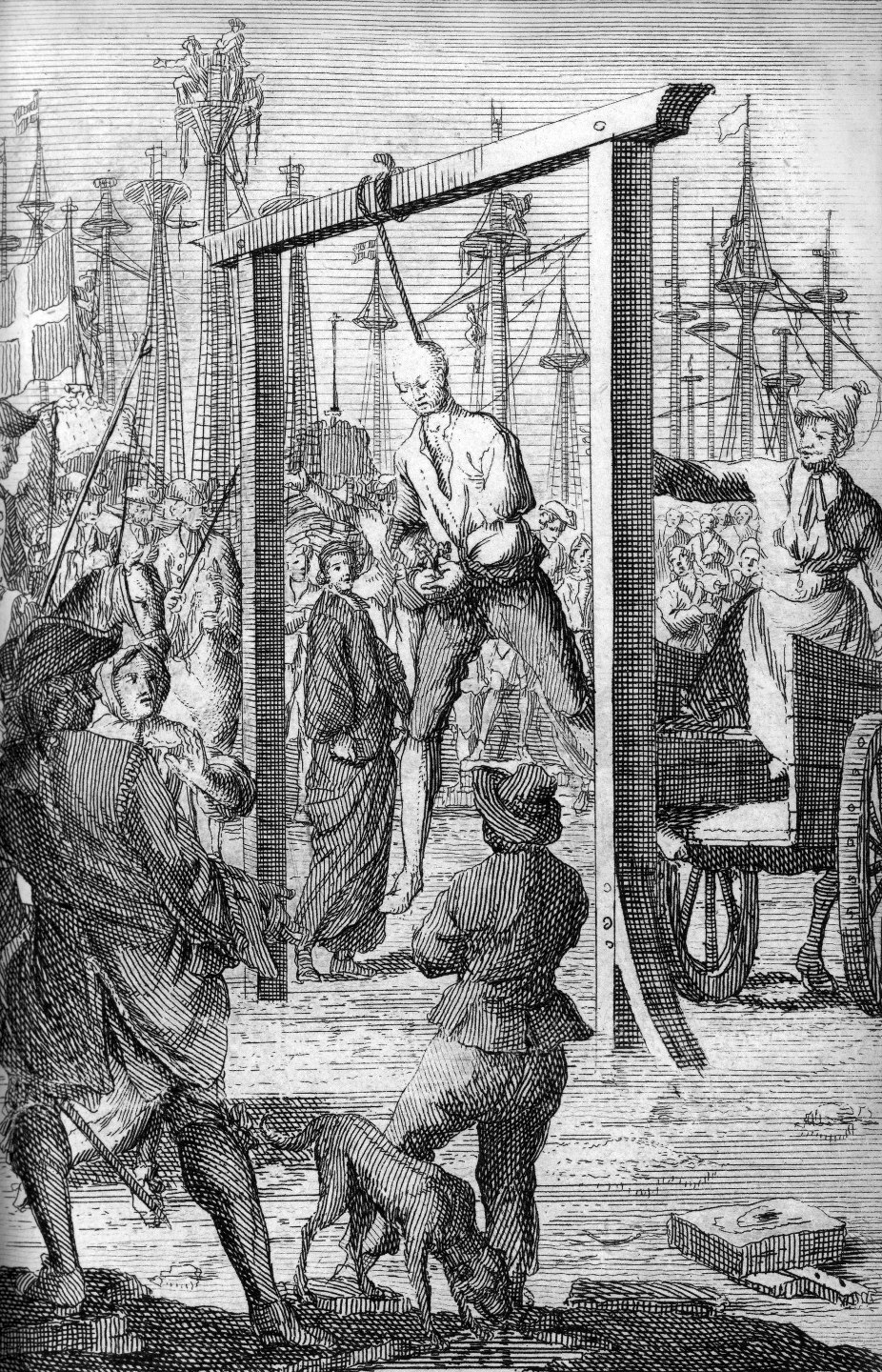
In recent episodes, I’ve delved into the bloody story of how the pirate crews sailing under Stede Bonnet and Richard Worley were captured and brought to Charleston, and the details of how they were tried, convicted, and sentenced to die. Now let’s turn our attention to the final steps of this story, in which the citizens of Charleston witnessed the very public execution of the offending mariners.
According to the manuscript journal of the South Carolina Court of Vice Admiralty, Judge Nicholas Trott condemned forty-nine men to be hanged for piracy at a series of thirteen trials held in November of 1718. After pronouncing his sentence of death in each of their respective cases, Judge Trott decreed that the guilty parties were to be taken from the courtroom “to the place from whence they came [that is, the Watch House], and from thence to the place of execution.” In order words, at the time of sentencing, the court did not specify the date or the location of their collective executions. This omission was, in fact, a very normal procedure in English law, and also very normal in eighteenth-century Charleston because there were no permanent facilities for capital punishment anywhere in South Carolina at that time. There were always preparations to be made, so the normal pre-execution protocol involved a further step. Soon after sentencing, the court would issue a warrant to the marshal instructing him to execute the court’s sentences at a specific time and place. As president or presiding judge of the Court of Vice Admiralty in 1718, Nicholas Trott would have issued several such warrants for execution, or “death warrants,” to Thomas Conyers, who took over the role of provost marshal after the negligence of his predecessor, Nathaniel Partridge, led to the escape of Stede Bonnet and David Heriot on October 24th. Following normal protocol on the specified days of execution, the marshal would have read aloud, or “published” by viva voce, each warrant before he carried out the sentence. The step added legitimacy and drama to the execution, and, in the case of hanging forty-nine pirates, it lengthened the process as well.
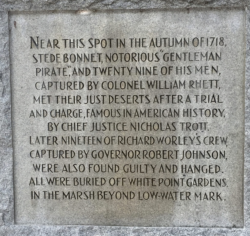
Nicholas Trott’s written warrants to Marshal Conyers do not survive, of course, but, the transcriptions of eleven of these trials, published in 1719, tell us the date and location of two of the three hanging episodes that took place in late 1718. According to that publication, twenty-nine of the crewmen from the pirate sloop, Revenge, were hanged on Saturday, November 8th, 1718, “at the White Point near Charles-Town.” That same trial transcript, published just months after the fact, also states that their leader, Major Stede Bonnet “was executed at the White-Point near Charles-Town,” four-and-a-half weeks later, on Wednesday, December 10th.[1] Between these two events, there was another Vice Admiralty trial of a separate group of pirates, survivors of the crewmen under Captain Richard Worley, nineteen of whom were condemned on November 24th, 1718. The date and location of their execution does not appear in any surviving records from this era, but we can reasonably conclude that those nineteen men were hanged, like Bonnet and his crew, “at the White Point, near Charles-Town.” So, what exactly did “White Point” mean to the people of Charleston in 1718?
Defining White Point
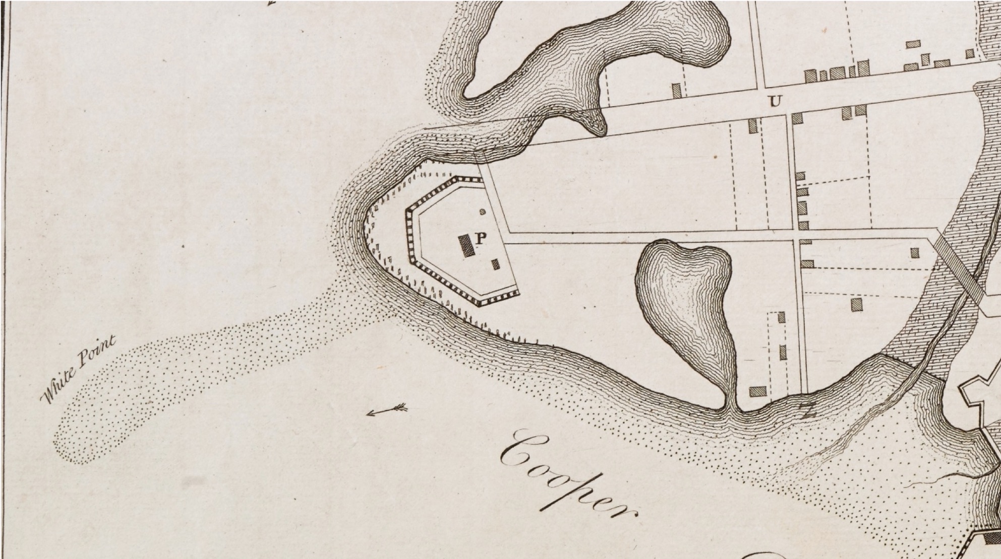
In 1701, the South Carolina legislature ordered the Commissioners of Fortifications to construct a defensive breastwork at “the White Poynt,” complete with a platform for mounting six cannons. Owing to the paucity of extant records from the early years of the eighteenth century, it’s difficult to determine whether or not that defensive work was ever constructed. In 1702 the legislature authorized the construction of a brick watch house “near the white Poynt,” and in 1703 debated the addition of another defensive “work” or “trenchment” at the site to protect soldiers in case of an enemy landing. In December of that year the South Carolina legislature passed an act to enclose the highest and driest sixty-two acres of Charles Town with a system of walls connected by fortified bastions and salient angles, surrounded by a moat and accessed through a drawbridge. White Point was left outside of these works, but it continued to play an important part in the town’s defensive strategies. In 1708 the South Carolina legislature ratified an act to construct “trenches” or entrenchments “along the White Point and other necessary places” in the town. These earthwork defenses were probably built, as Carolina was then under the nearly constant threat of attack from our Spanish and French neighbors, but they are not depicted in any known maps of Charleston. A strong hurricane in 1713 caused extensive damage to the town, and may have destroyed the fortifications at White Point. If so, these works were soon rebuilt, for in 1724 the legislature considered the best use of “the fort and great guns at White point” and determined to remove the cannon to another location. A decade later, these early fortifications were replaced by the construction of Broughton’s Battery, a large brick structure completed in 1737. Broughton’s Battery, sitting on top of the lots reserved for a fortification in 1688, is clearly depicted on a well-known map published in 1739 under the title “The Ichnography of Charles-Town.”
In short, “the White Point” in the early days of Charleston was a publicly-owned, partially-fortified site at the southernmost tip of the peninsula, adjacent to mudflats that were washed by the daily ebbing and flowing of the tides. Furthermore, the White Point was a place of some prominence as well. Because it was located at the confluence of the two main rivers, and at the western end of the harbor, the White Point was a landmark visible to all watercraft entering the harbor or plying up and down the rivers. The decision to hang pirates “at the White Point” represents the government’s desire to ensure that everyone coming and going to and from Charleston would see the dangling corpses on display.[2]
Divisum Imperium at White Point
The South Carolina Court of Vice Admiralty derived its legal authority from an English piracy law ratified during the reign of Henry VIII in 1536. That law did not extend to the colonies in America, however, so the English Parliament ratified an updated version of this “Piracy Act” in the spring of 1698/9. The fifth section of that law specifies that all persons found guilty of piracy in a Court of Vice Admiralty “shall be executed and put to death at such time in such manner and in such place upon the sea or within the ebbing or flowing thereof as the president or the major part of the court by warrant directed to a provost marshal. . . shall appoint.”[3] This legal instruction to hang pirates on the ground between high and low tide seems to have been carried out regularly by Vice Admiralty courts throughout the English (later British) realm in the eighteenth century. I’ll mention just a few examples to prove the point. In urban London, the Admiralty Court hanged its condemned prisoners, including the famous Captain William Kidd in 1701, at a place called “Execution Dock,” which was located along the shoreline of Wapping, a waterfront district along the north shore of the River Thames. In Boston in mid-November 1717, several pirates were hanged on gallows erected “within the flux and reflux of the sea.”[4] At a British outpost on the west coast of Africa in 1722, a number of pirates were condemned to be hanged “within the flood-marks;” that is to say, between the low and high water marks of the coast.”[5] Back in Charleston in the spring of 1769, a mariner named Matthew Turner was tried in in the South Carolina Court of Vice Admiralty for the murder of a shipmate on the high seas. Turner was found guilty, and sentenced to be hanged “upon a gallows to be erected, between high and low water mark, on the south west point of the marsh before Charlestown [that is, on Shute’s Folly].”[6]
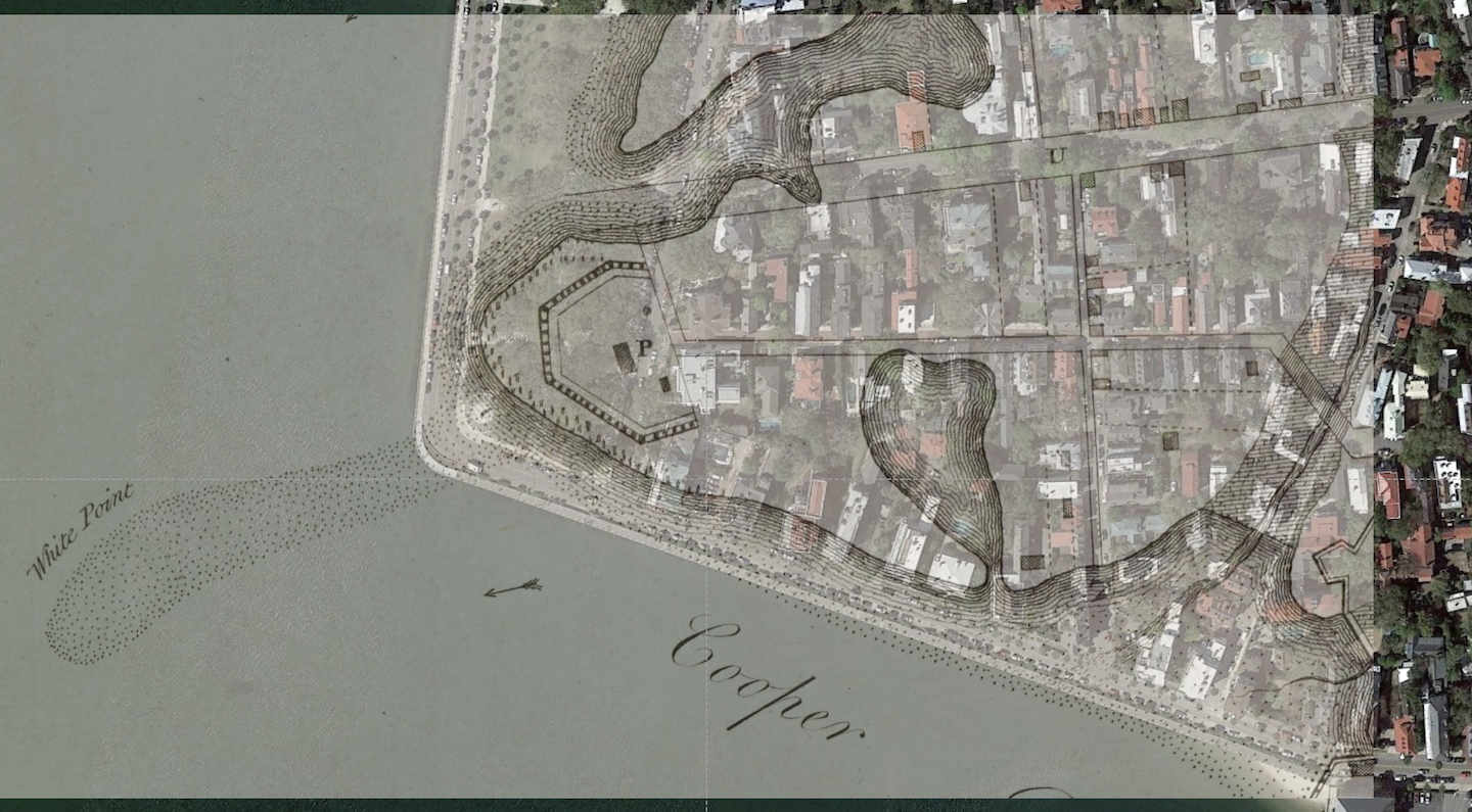
So, if the prescribed legal setting for the execution of pirates was indeed observed here in Charleston in 1718 (and we have no reason to suppose it was not), we can conclude that Stede Bonnet and his crew, as well as the remnants of Richard Worley’s crew, were all hanged at the extreme southeasternmost point of the White Point, on the beach between the ebbing and flowing of the tides. Due to the paucity of extant surveyors’ records from that era, however, it’s practically impossible to determine the exact location of the high and low water marks at White Point in 1718. The present-day topography of that site is remarkably different from its appearance three hundred years ago. From the construction of Broughton’s Battery in the mid-1730s, through the addition of further fortifications in the 1750s and 1760s, then the leveling of the site after the American Revolution, and then several sustained episodes of filling and expansion from the late 1830s through the early 1850s, the geographic boundaries of the dry land at White Point have increased dramatically over the past three centuries. In the text version of today’s episode, I’m including an image that overlays a portion of the 1739 “Ichnography of Charles-Town” on a Google Earth image of present-day White Point. As you can see in that composite image, the water, land, and “intertidal zone” are all shaded differently in the 1739 map, which allows us to form an educated guess about the possible legal location of the hanging of forty-nine pirates in 1718.
The Manner of Their Burial
The earliest recorded instance of pirates being executed in Charleston dates from the early 1680s. While there are no extant documents that tell us the exact date of this episode, or the names or even the exact number of pirates involved, a 1684 summary of the event does provide some useful information. In May of that year, William, Earl of Craven, the Palatine (leader) of the Lords Proprietors of Carolina, wrote to the English Board of Trade to defend the colony against accusations of harboring pirates. Lords Craven assured the board that he had received word from Carolina that pirates were not welcome there. In fact, he asserted, a pirates captain and his crew had recently been tried and executed in Charleston, and three of “the most guilty of his company hung in chains at the entrance of the port and there hang this day for an example to others.”[7]
While it is certain that the bodies of some men hanged for piracy were displayed after their death, the bodies of at least some ex-pirates received a normal terrestrial burial following their execution and a brief period of public display.[8] It appears that pirate captains, or ringleaders or principal offenders, were often selected for public display as warning to other mariners. For example, two men convicted of piracy in Boston in May 1724 were both executed by hanging, but their bodies were disposed of differently. One was buried and the other hung in chains.[9] An enslaved man named Caesar, suspected of enticing slaves to escape to St. Augustine, was one of several people executed here in Charleston in the spring of 1739. After his death, Caesar’s body was “hung in chains at Hangman’s Point opposite to this town [probably meaning Shute’s Folly], in sight of all Negroes passing and repassing by water.”[10]
So, in the autumn of 1718 here in Charleston, did local authorities display the corpses of some, all, or none of the forty-nine pirates hanged at White Point? As with so many aspects of this story, there aren’t any surviving contemporary records that provide an answer, or even a hint. Stede Bonnet was the owner and titular leader of the pirate sloop, Revenge, so it’s possible that local authorities singled out his corpse for public display. Despite his late-in-life turn to piracy, however, Bonnet was also considered a “gentleman,” and might have been spared the posthumous humiliation of being hung in chains to rot. In truth, there simply are no surviving facts about this matter from which to draw any conclusions. In my personal opinion, however, based on my experience of plowing through the early government records of South Carolina, I suspect that at least some of the forty-nine pirates hanged here in 1718 were left hanging at White Point for some unknown period of time. These mass executions were dramatic public spectacles, and I’m sure local authorities wanted to capitalize on their terrifying effect by perpetuating the visual impact for at least a while.
At some point, however, the dramatic spectacle of human bodies hanging in the breeze becomes an environmental nuisance. Even in the cool winter of 1718-1719, the smell of rotting flesh would have blown across the peninsula. The only people living in the vicinity of White Point in 1718 were a few households near the southeast corner of what is now Meeting Street and Water Street. The fancy mansions we now see at the south ends of Church, Meeting, and King Streets were mere dreams at that time. Church Street didn’t extend south of Vanderhorst Creek until late 1736. Meeting Street wasn’t extended south of that creek until about 1740. In short, there were hardly any people living within three hundred yards or so of the southern tip of White Point, but the prolonged exposure of any pirate corpses would have been unpleasant to the inhabitants who lived immediately to the north. We have no idea whether or not some or all of those bodies were eventually buried, but at least we can consider where they might have been interred.
Historian and physician David Ramsay, writing in his History of South Carolina at the turn of the nineteenth century, stated that the pirates of 1718 “were hanged and buried on White Point, below high water mark.”[11] Dr. Ramsay settled in Charleston just prior to the American Revolution, so it is possible that he was acquainted with someone who had witnessed the 1718 pirate executions and burials as a child. It’s also possible, however, that Ramsay merely conflated the hanging and burial, and assumed both events took place at the same location. If we entertain the possibility that the pirates were in fact buried at White Point, we have to consider whether they were buried as they were hanged, between the ebbing and flowing of the tide, or in a normal fashion on high ground. Pirate precedent might argue in favor of burials within the “intertidal zone” between high tide and low tide, but practical realities might suggest otherwise.
Imagine, for a moment, the task of digging a rectangular hole, of a sufficient depth for a human corpse, or a few dozen human corpses, on a beach, in the brief window of time between low and high tide. The clock is against you, so the grave you might dig is perhaps shallower than you’d prefer. But these are pirates, so a meager grave is a fitting reward for that criminal lifestyle. You deposit the remains, shovel back the sand, and call it a day. Within a few cycles of the tide, however, you’re bound to find that a shallow beach grave is an insufficient defense against the hydraulic forces of the water and the curiosity of the wildlife that feeds along the shoreline.
It is possible that the pirates of 1718 were buried on some unknown piece of “high ground” near the very low-lying vicinity of White Point. I’ve been searching for historic plats of this area for many years, but I haven’t seen any document that indicates any burials, let alone a mass grave. The waterfront real estate around White Point was transformed by a series of large-scale fortification projects in the mid-1700s, and it became a predominantly residential area only after the American Revolution. If anyone discovered a grave or a number of graves during the redevelopment of White Point in the late-eighteenth and early-nineteenth centuries, they didn’t write about it or mark the graves on any map or plat. Considering the topographical nature of this site, which was once just barely above sea level, I think it’s possible that the pirate corpses were interred elsewhere, in the town’s earliest pauper’s field.
Charleston’s first public cemetery, dating back to at least the 1680s, was located on the west side of the peninsula, adjacent to the high water mark of the Ashley River, extending from the west end of what became known as Queen Street northward to what became known Magazine Street. In a law ratified in October of 1698, this cemetery was called “the old burial place,” and was distinct from the cemeteries associated with individual churches.[12] The “old burial place” was used primarily for the interment of paupers and enslaved people, and in continued to be used through the end of the American Revolution. During the late 1930s, most of this area was excavated and redeveloped as a public housing project called the Robert Mills Manor. The construction crews working on that project some eighty years ago almost certainly encountered a healthy mix of dirt and bones at the site, but no one seemed to mind at that time. Whether or not they found the remains of pirates mixed among the earth is anyone’s guess today.
Conclusion
Three hundred years after Charleston dramatic encounter with the pirate scourge of 1718, we have precious few documentary clues that help us to re-imagine that grizzly affair. In the past few episodes, I’ve attempted to provide an accurate representation of those historic events as they were recorded in contemporary documents, and to provide an alternative to some of the exaggerated, semi-fictional accounts that you might encounter elsewhere. As I’ve said before, whether or not you’re a fan of pirate history, these events form a very significant episode in the history of Charleston. Following the mass execution of pirates in late 1718, the town’s collective frustration with the passive administration of the Lords Proprietors of Carolina reached a fever pitch in 1719. Combined with other long-simmering problems in the colony, the handling of this pirate affair led to the overthrow of the government twelve months later—an equally dramatic event that forever changed the trajectory of South Carolina. But that’s a story for a future journey on the Charleston Time Machine. . . .
[1] Anonymous, The Tryals of Major Stede Bonnet, and Other Pirates (London: Benj. Cowse, 1719), 37, 43.
[2] The nineteenth-century pirate historian, Shirley Carter Hughson, reported in 1894 that local “tradition has it that the execution was held at a place now in Meeting Street near the corner of Water [Street].” In 1718, however, that site was private property with an active settlement, and thus a very unlikely setting for a mass public execution. See Shirley Carter Hughson, The Carolina Pirates and Colonial Commerce, 1670–1740 (Baltimore: Johns Hopkins Press, 1894), 106.
[3] William III, 1698-9: “An Act for the more effectuall Suppressions of Piracy [Chapter VII. Rot. Parl. 11 Gul. III. p. 2. n. 5.],” in Statutes of the Realm: Volume 7, 1695–1701, ed. John Raithby (s.l: Great Britain Record Commission, 1820), 590-594. British History Online, accessed December 6, 2018, http://www.british-history.ac.uk/statutes-realm/vol7/pp590-594.
[4] Anonymous, The Trials of Eight Persons Indited for Piracy &c. of whom Two were acquitted, and the rest found Guilty (Boston: B. Green for John Edwards. 1718), 14.
[5] Charles Johnson, A General History of the Pyrates (second edition; London: 1724), 298–99.
[6] See South-Carolina and American General Gazette, 24 April–1 May 1769. Before the execution, Governor Montagu reprieved Turner’s sentence “till his Majesty’s pleasure shall be known,” but I have not yet found the conclusion of his case. See South-Carolina and American General Gazette, 1–8 May 1769.
[7] The Earl of Craven to the Board of Trade and Plantations, 27 May 1684, in A. S. Salley Jr., indexer, Records in the British Public Record Office Relating to South Carolina 1663–1684 (Atlanta: Foote and Davies for the Historical Commission of South Carolina, 1928), 284–85.
[8] The pirates Purser and Clinton were executed at Wapping in the 1583, their bodies allowed to hang for two high tides, and then buried in a normal “Christian” manner. See Samantha Frénée, “Pirates and Gallows at Execution Dock : Nautical Justice in Early Modern England,” Criminocorpus [Online], Les Fourches Patibulaires du Moyen Âge à l’Époque moderne. Approche interdisciplinaire, Communications, Online since 14 December 2015, URL: http://journals.openedition.org/criminocorpus/3080, accessed on 6 December 2018. The author cites Thomas Heywood, A True Relation, of the Lives and Deaths of the two most Famous English Pyrats, Purser, and Clinton; who lived in the Reigne of Queene Elizabeth (London, John Oakes, 1639), part II, chapter 4
[9] See J. Franklin Jameson, ed. Privateering and Piracy in the Colonial Period: Illustrative Documents (reprint; New York: Augustus M. Kelley, 1970), 344–45.
[10] South-Carolina Gazette, 5–12 April 1739.
[11] David Ramsay, The History of South Carolina (1809), 1: 116.
[12] See Act No. 162, “An Act for settling a Watch in Charles Town, and for preventing of Fires, ratified on 8 October 1698, in David J. McCord, ed., The Statutes at Large of South Carolina, volume 7 (Columbia, S.C.: A. S. Johnston, 1840), 7–12.
[13] The number of Worley’s crew—nineteen—cited on this monument indicates that someone on the Historical Commission read the manuscript records of the Admiralty Court, which gives that number, instead of Hughson’s statement, published in 1894, that all of Worley’s surviving crew, twenty-seven men, were hanged. The records of the City of Charleston Historical Commission are available at the Charleston Archve at the Charleston County Public Library.
PREVIOUS: The Charleston Pirate Trials of 1718
NEXT: The Golden Christmas of 1852
See more from Charleston Time Machine