
This week we continue our conversation about Charleston’s Liberty Tree, a majestic live oak that shaded many important events associated with the American Revolution. Because it hosted gatherings of rebellious South Carolinians, British soldiers destroyed the tree in 1780 and tried to obliterate its legacy. Some local sons of the Revolution never forgot its symbolic role, and actively sought to preserve memory of the tree throughout the nineteenth century. Thanks to their trail of documentary clues, we can reconstruct a plausible path to the former site of the tree that symbolized resistance against injustice.
From Independence to Incineration, 1776–1780:
After adopting a final draft of the Declaration of Independence in Philadelphia on July 4th, 1776, the Continental Congress sent express riders to carry printed copies of the document to the capital of each of the North American states. The copy sent to South Carolina arrived in Charleston on Friday, August 2nd, and the state government immediately made plans for a formal public reading of the document on Monday, August 5th. The town boasted three independent newspapers at that moment, and each no doubt published descriptions of the public events of August 5th. Copies of the relevant issues of those three newspapers have not survived, however, so we have to look elsewhere for details.
A handful of anecdotes about the events of August 5th, written by eye-witnesses, survived into the nineteenth century, each making reference to a formal recitation of the Declaration of Independence at Charleston’s Liberty Tree. In the course of the nineteenth-century, several historians conflated and embellished these anecdotes into a compelling narrative about a grand civil and military procession to the Liberty Tree and an elaborate ceremony surrounding the reading of the Declaration at that site. Unfortunately, that narrative is inaccurate. Other contemporary documents, most notably the manuscript diary of William Tennent that surfaced in the twentieth century, clarify the sequence of events that took place in Charleston on August 5th, 1776.[1]
In the several years following the reading of the Declaration of Independence in August 1776, Charlestonians continued to gather at Liberty Tree to celebrate patriotic occasions. Details about such events are scarce owing to the vicissitudes of the war, but the few known facts seem to indicate a trend. The Charleston Artillery Company, which became the Charleston Battalion of Artillery in the spring of 1778, marked the anniversaries of Carolina Day (June 28th) in 1777 and 1778 with celebrations at Liberty Tree. They probably continued that tradition in the summer of 1779, but documentary evidence of such an event is lacking from that tense period. By combining this information with the story of the genesis of Charleston’s Liberty Tree, we might infer the existence of a forgotten relationship.
Most of the skilled tradesmen or “mechanics” who formed the earliest-known audience at Liberty Tree in 1766 were also members of the Charleston Artillery Company. Christopher Gadsden, who delivered a fiery patriotic speech to the mechanics under Liberty Tree in 1766, served as captain of the Artillery Company from its inception in 1757. Daniel Starnes, an obscure figure who was apparently the unofficial groundskeeper of Charleston’s Liberty Tree, also served as a private in the Battalion of Artillery for the duration of the war. (I’ll share more information about Mr. Starnes in an upcoming episode). By repeatedly gathering at this site over a period of at least fourteen years, the Charleston Battalion of Artillery appears to have embraced the site of Liberty Tree its own turf. That sense of connection continued long after the tree’s disappearance, as we’ll see in a moment.[3]
Charleston’s Liberty Tree, like similar wooden symbols in Boston, Newport, and other communities, served as a sort of lightning rod for the patriotic vigor that bound like-minded Americans to the cause of liberty and independence in the 1770s. It was, in a manner of speaking, a sacred place dedicated to the contemplation and celebration of noble ideas. For these very reasons, people opposed to the ideas discussed beneath the various American Liberty Trees viewed them as obnoxious venues for seditious behavior. Loyalists to the British government cut down Boston’s Liberty Tree in the summer of 1775, for instance, and similar attacks befell trees in other rebellious communities. Charleston’s Liberty Tree remained standing until British military forces overwhelmed the American defenders in the summer of 1780. Sometime after capturing the colonial capital of South Carolina on May 12th, General Henry Clinton ordered his troops to chop down the majestic live oak and burn it into oblivion. I’m not familiar with any contemporary sources that record the date or any details of this destructive work, but there is no doubt that the work was accomplished shortly after British forces occupied Charleston.
In surviving documents created in the years immediately after the conclusion of the American Revolution, one finds few references to Charleston’s Liberty Tree. The veterans who had gathered beneath its evergreen branches in the 1760s and 1770s might have lamented its destruction in 1780, but they didn’t record or publish any expressions of grief in the aftermath of the long War of Independence. The tree had served a useful and noble purpose in the past, and its votaries no doubt carried fond memories of it as they moved on with their lives. In later years, as their memories faded and the landscape evolved, knowledge of Liberty Tree’s location became increasingly vague. Our ability to place it definitively on a map in the twenty-first century is limited by a paucity of geographic clues, but all is not lost. Thanks to the collective memories of one local family, spread across three generations, we have sufficient number of metaphorical breadcrumbs to lead us back to the approximate site of Charleston’s Liberty Tree. Our journey begins with a visit to the bucolic landscape once known as Mr. Mazyck’s pasture.
Mazyck’s Pasture and Mazyckborough:
Mr. Mazyck’s pasture was a large parcel of land on the east side of the Charleston peninsula, adjacent to the Cooper River, that was owned by the Mazyck family between the 1690s and the 1790s. At this point, I could dive into the long history of the Mazyck property that eventually became Mazyckborough, but I’ll resist the temptation and save that conversation for another time. For the moment, I’ll simply note that Mr. Mazyck’s pasture encompassed all the land now bounded on the south by Calhoun Street, on the north by Chapel Street, on the west by Elizabeth Street, and on the east by the Cooper River. Christopher Gadsden (1724–1805) purchased in 1758 the land immediately to the south of Mazyck’s pasture, now covered by the Gaillard Center for the Performing Arts and Gadsden’s Wharf. A tidal inlet flowing westward from the Cooper River once formed a natural boundary between the lands Mr. Mazyck and Mr. Gadsden. That inlet is now the eastern part of Calhoun Street, right in front of the Charleston County Public Library’s main branch, and still tends to flood during heavy rains at high tide.
Both Mazyck’s pasture and Gadsden’s Green, as it was once called, stood outside the original boundaries of urban Charleston until the creation of Boundary (now Calhoun) Street in 1769–70. That thoroughfare created a new boundary between the town and what was then called “the Neck.” From that point forward, Mr. Gadsden’s property, including what would become Gadsden’s Wharf, were technically within the unincorporated limits of Charleston proper, while Mr. Mazyck’s pasture remained outside the town. Knowledge of this information helps us to understand a subtle but useful geographic clue contained within a colonial-era source.
The two earliest published notices of events at Liberty Tree, dating from October 1768, both mention that the men who gathered there returned to Charleston by way of King Street. At that time, there were no thoroughfares in the neighborhood. Meeting Street terminated at Boundary Street prior to 1785 (see Episode No. 81). The tidal inlet that once formed part of Calhoun Street prevented traffic from flowing north and south along what is now Alexander Street and from Elizabeth to Anson Street. King Street, called the “Broad Path” immediately outside the town, was the only road leading in and out of the colonial capital. To reach Liberty Tree in the 1760s and 1770s, therefore, most Charlestonians would have travelled north on King Street and passed through the Horn Work. Turning east just outside the town gate, they could have walked in a straight line that is now Charlotte Street approximately 2,200 feet through Mr. Wragg’s pasture into Mr. Mazyck’s pasture. Unless they arrived by boat from the Cooper River, their return to town would have followed the same route in reverse.
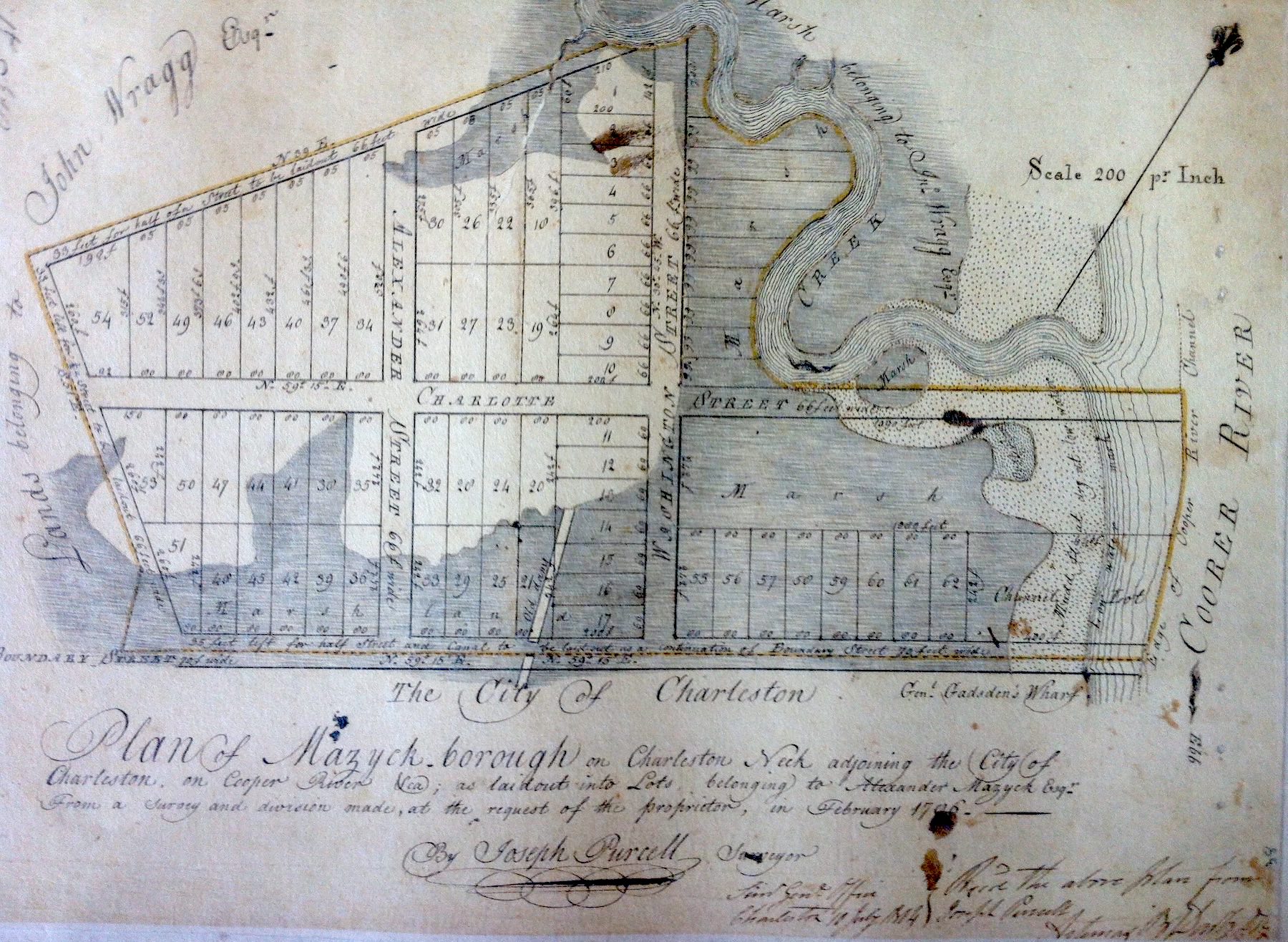
Ownership of this sub-urban tract of fifty-odd acres passed from the immigrant Isaac Mazyck (1661–1736) to his son, Isaac Jr. (1700–1770), to junior’s brother, Paul Mazyck (1702–1749), to Paul’s son, Alexander Mazyck (1736–1786). In the days before his untimely death in 1786, Alexander Mazyck hired the talented surveyor, Joseph Purcell, to prepare the landscape for a new residential development. That February, Mr. Purcell drew a plan to transform the old pasture into a petite neighborhood called Mazyckborough. The initial subdivision contained several broad streets named after members of the family, sixty-two numbered lots of varying sizes, and a few un-numbered marsh lots along the Cooper River. To identify the neighborhood’s principal cross streets, Mr. Mazyck applied his own name, Alexander, and that of his wife, Charlotte.[5]
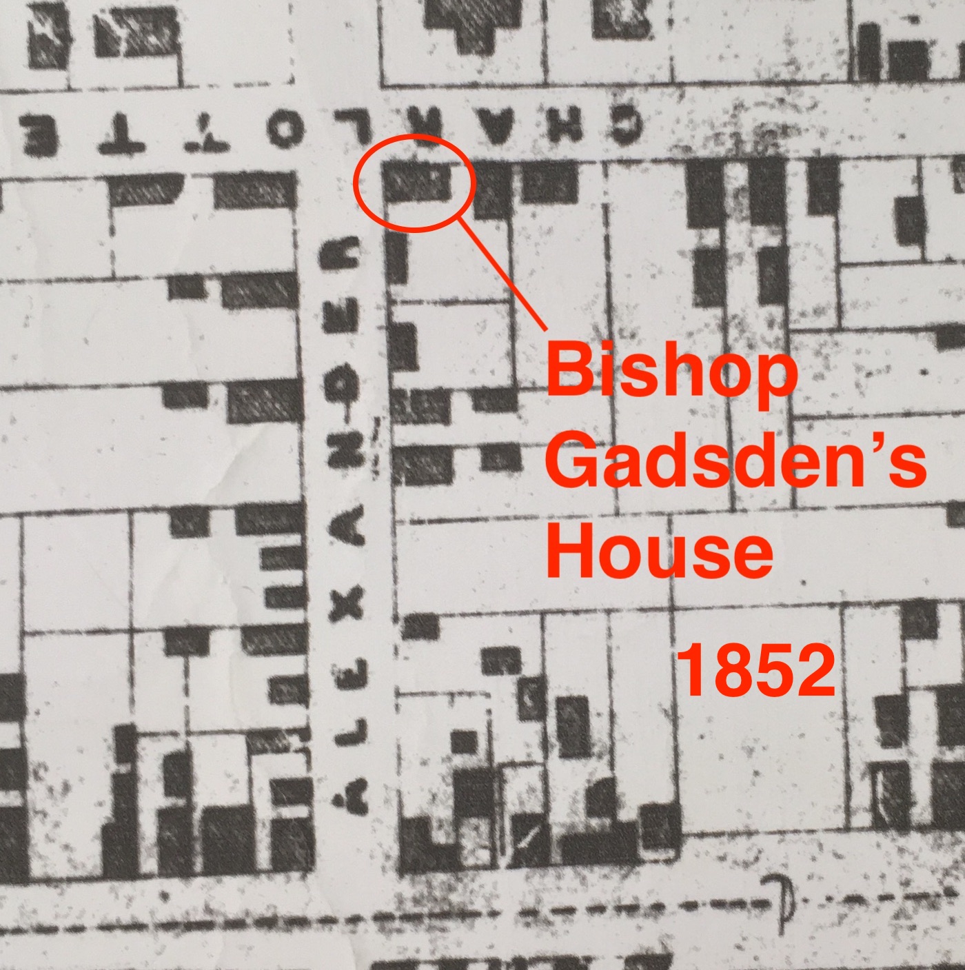
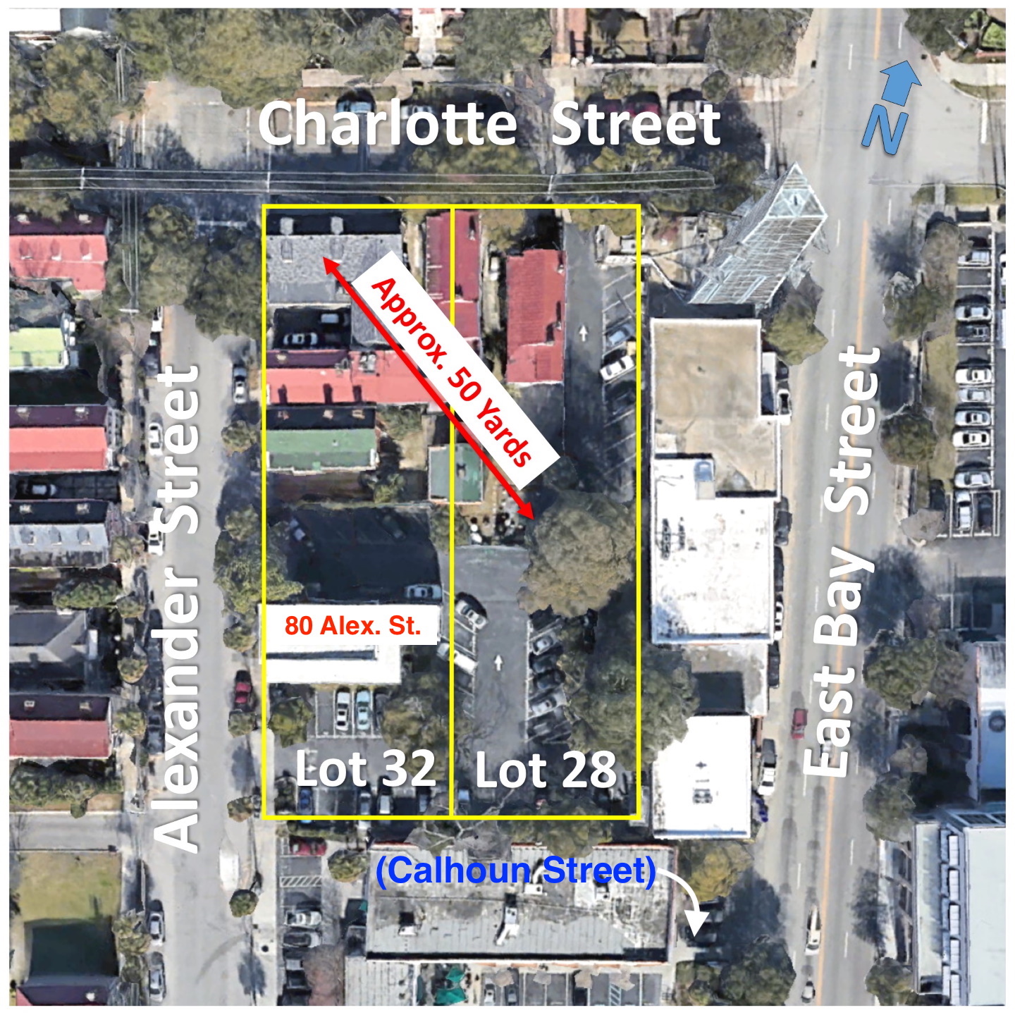
The vacant lot containing the Liberty stump was among several Mazyck lots sold at auction near the Exchange building on October 9th, 1794. One of the bidders that day was a local merchant named William Dewees (ca. 1749–1827), who paid £461 sterling for two of the lots in Purcell’s plan of Mazyckborough, numbered 28 and 32. These lots formed a rectangle encompassing seven-eighths of an acre situated at the southeast corner of Charlotte and Alexander Streets. More specifically, Lot No. 32 measured eighty feet along the south side of Charlotte Street and 242 feet along the east side of Alexander Street, while Lot No. 28, containing the same dimensions, formed its eastern neighbor.[7]
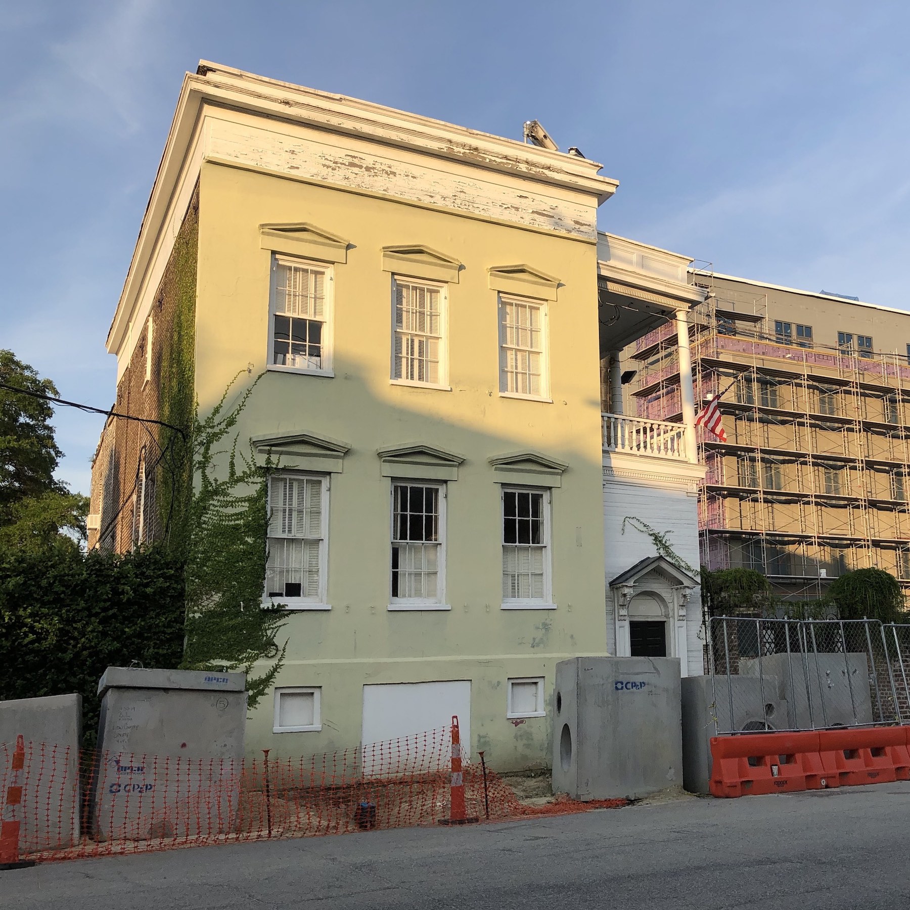
In the years following this purchase, sometime around the turn of the nineteenth century, William Dewees subdivided his two lots into four parcels of different sizes. On a pair of narrow lots facing Charlotte Street, comprising the northern half of Lot No. 28, he built two wooden tenements designed to generate rental income. On the northern end of Lot No. 32 at the southeast corner of Charlotte and Alexander Streets, Mr. Dewees built a large two-and-a-half story wooden house for family use. One hundred and sixty-two feet to the south of that corner, he built a three-story brick residence facing Alexander Street that occupied the southernmost parts of both lot No. 32 and No. 28. He also acquired other Mazyckborough lots in subsequent years, but those properties lie outside the scope of the present conversation.
William Dewees mentioned all four of the aforesaid houses in his 1827 will. He gave the rental tenements facing Charlotte Street to his son and daughter, Joseph Dewees and Ann Dewees Hamlin. Unmarried daughter, Jane Dewees (1800–1876), received the larger wooden house at the corner of Charlotte and Alexander Streets. The commodious brick residence or office facing Alexander Street was now superfluous, so William Dewees instructed his heirs to sell it and share the profits.[8] Three years later, in 1830, Jane Dewees married Rev. Christopher Edwards Gadsden (1785–1852), better known as Bishop Gadsden, and they occupied the house at the corner of Charlotte and Alexander Streets as their primary residence.[9] In 1837, the Dewees heirs sold the brick house facing Alexander Street to John Marshal, who updated the Federal-style house by adding piazzas and Greek-Revival details. The explosion of a nearby railroad depot on February 18th, 1865, ignited a fire that destroyed most of the wooden houses in this block, but Mr. Marshal’s brick house, built by William Dewees, survived. Although earthquake damage led to the removal of its uppermost story in 1886, this handsome edifice, now more than two hundred years old, has survived into the twenty-first century. Now identified as No. 80 Alexander Street, it forms an important landmark for re-imagining the early landscape of Mazyckborough.[10]
It’s important to recognize that the documentation surrounding the sales and subdivision of the early lots of Mazyckborough in the late 1700s and early 1800s includes no specific references to Charleston’s Liberty Tree or its former location. By leading you down the paper trail of William Dewees’s purchase and alteration of the lots numbered 28 and 32, however, I’ve endeavored to create a landscape in your imagination in which to plant the famous tree. Without this mental geographical setting, the following priceless clues, supplied by members of the Johnson family of Charleston, would lack meaning.
Clues from the Johnson Family:
New-York-born blacksmith William Johnson (1741–1818) came to Charleston in 1764 and participated in every stage of the American Revolution in South Carolina between 1765 and 1782. In the years after the war, contemporaries such as Governor John Rutledge and Bartholomew Carroll described William Johnson as an early advocate for American independence and an active participant in the earliest stages of the rebellion. As a master mechanic, a member of the Fellowship Society, and a member of the Charleston Artillery Company, Johnson was among those present at the earliest known meeting under Liberty Tree in 1766, when Christopher Gadsden implored his friends to persevere against tyranny.[11]
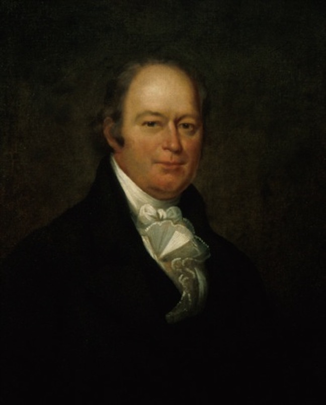
The exact timing of Judge William Johnson’s excavation is unclear, but I believe it took place sometime around the turn of the nineteenth century. In his 1851 publication of Traditions and Reminiscences, Joseph Johnson provided valuable clues that point to the early subdivision of Mazyck’s Pasture. To orient his readers, he said the tree stood “near the centre of that square in Mazyckborough, now bounded on the north by Charlotte street, east by Washington street, south by Boundary [Calhoun] street, and west by Alexander street.” He didn’t mention East Bay Street in this geography because that major thoroughfare didn’t extended to the north of Calhoun Street until the early 1950s. A further clue from Dr. Johnson points to a smaller range within that large square: “I remember to have seen the low black stump [of Liberty Tree] after the revolution. When this piece of land was purchased by Mr. William Dewees, and enclosed for building, the late Judge William Johnson, of the Federal Court, requested that the root when grubbed up might be given to him.”[12]
Johnson’s identification of William Dewees as the post-war owner of the Liberty Tree site reduces our search from the broad geographic scope of Mazyck’s pasture down to a handful of lots. As we learned earlier, however, William Dewees acquired two lots at the corner of Charlotte and Alexander Streets in the autumn of 1794 and later acquired additional property in other parts of Mazyckborough. On which of these several lots might we look to find the roots of Charleston’s Liberty Tree? To answer this question, we turn to another valuable clue provided by Joseph Johnson. In an extract from a private letter published in the Charleston Courier in the summer of 1843, Johnson described Liberty Tree as “a wide spreading, beautiful live oak, in that part of Mazyckborough, owned by the heirs of Mr. Wm. Dewees, and grew about fifty yards south eastwardly of Bishop Gadsden’s residence.”[13]
Joseph Johnson’s several geographic clues point to a reasonably precise location of Charleston’s Liberty Tree, but when did William Johnson excavate, or cause to be excavated, the stump of the famous tree? We can conclude that Judge Johnson sought permission to retrieve it sometime after 1794, whenever Mr. Dewees started to “enclose” his lots “for building.” We also know that the excavation was completed sometime before 1817, by which time the tree’s remaining roots had been fashioned into a variety of wooden souvenirs. For this fact, the Library of Congress provides indisputable proof. Their large collection of the surviving papers of President Thomas Jefferson includes a letter from Supreme Court Justice William Johnson, written on the 4th of March, 1817, that accompanied a small gift to the man who had nominated him to Federal bench in 1803. In the letter, Johnson description of the gift provides a valuable second-hand summary of the first political meeting under Charleston’s Liberty Tree in 1766:
“It is a walking stick which appears to be of tortoise shell but is in fact only that substance moulded over a hickory rod by a simple but ingenious process which will immediately occur to you. I hope you will find it somewhat of a rarity. But Sir the head of it is in my eye & I hope it will be in yours more an object of interest. It is taken from the root of an oak under which your venerable friend Gadsden assembled the first little band of conspirators that convened in our country. The place where it stood was remote and retired from observation. About thirty of them met of whom but one is now living. After solemnly deliberating on the interesting subject which brought them together, with hands crossed and united round the tree, they took the dangerous resolution which you will read on the scroll which encircles the oak engraven on the head of this walking stick. ‘We will resist.’ I believe it to be a fact that not an individual swerved from this resolution. With regard to their leader [Christopher Gadsden] no one knows better than yourself with what energy & firmness he adhered to it. The tree was cut down by the British but I took up the root and have made use of it in various ways to keep alive the sacred flame of ’76.”[15]
In his aforementioned 1843 letter and in his 1851 book of Traditions and Reminiscences, Dr. Joseph Johnson confirmed that his older brother “had portions of it [Liberty Tree roots] cut and turned into cane-heads, one of which was given by him to President Jefferson, and others to different friends.” Dr. Johnson also reported that “a part of it was sawed into thin boards, and made into a neat ballot box, which he presented to the ’76 Association,” a fraternal organization of Charleston dedicated to preserving the spirit of the American Revolution. But the ballot box made from the roots of Liberty Tree perished nearly two centuries ago. Johnson said “when the great fire of 1838 destroyed Mr. [Samuel] Seyles’ [sic] establishment [on Meeting-street], at which the Society held their meetings, this interesting relic was consumed, with the minutes of the Association, recording his letter and donation.”[17]
Efforts to Mark the Site:
The brothers Johnson, William and Joseph, clearly remembered the location of Charleston’s once-majestic Liberty Tree and even venerated the remnants of its woody roots, but they did not mark its former location in any permanent fashion. Joseph Johnson’s 1851 book included a small depiction of Liberty Tree on a large map of the Charleston peninsula as it appeared during the time of the Revolutionary War, but this imprecise illustration provides only a vague indication of the tree’s general location.[18] Nevertheless, some Charlestonians, as early as 1824, if not before, had expressed the need for a substantial marker to preserve the memory of Liberty Tree. From time to time over the decades, newspaper columnists reminded the public of its former glory. At the turn of the twentieth century, the publication of Edward McCrady’s multi-volume history of early South Carolina probably provided the final push of inspiration to bring this idea into fruition.[19]
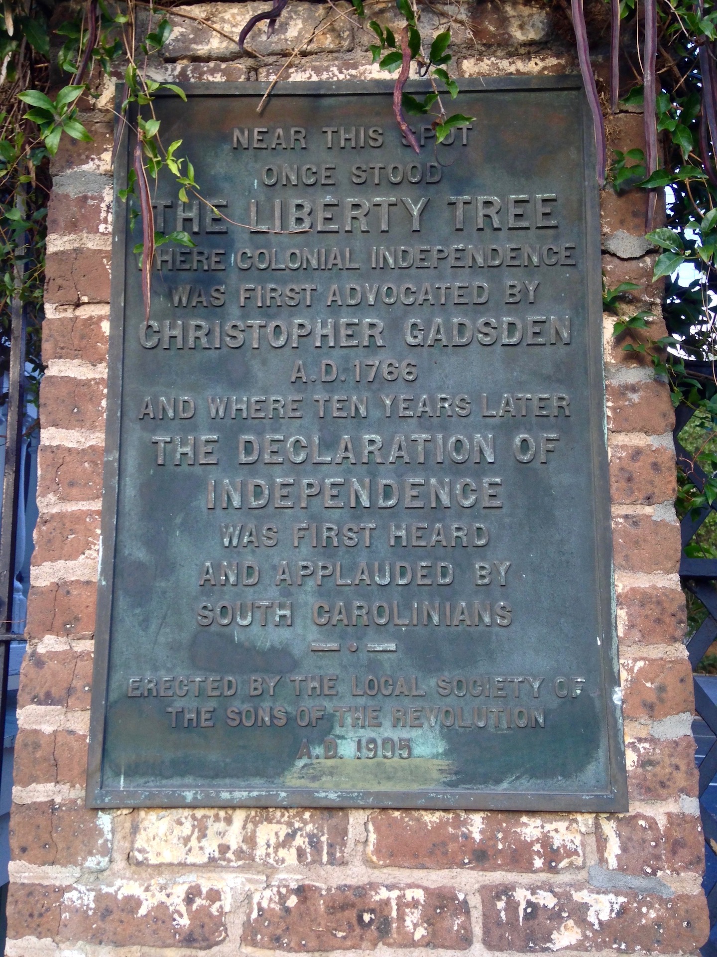
Like his father before him, Rev. John Johnson probably grew up hearing stories about Liberty Tree and his family’s active participation in the struggle for American independence. It’s not unreasonable to think that Doctor Johnson might have taken his son to see the site of the famous tree near the corner of Charlotte and Alexander Streets. At the turn of the twentieth century, Rev. Johnson might have described to his colleagues how his uncle, William Johnson, had excavated its roots at the turn of the nineteenth century. Informed by these family traditions and documentation in 1905, the Sons of the Revolution selected what I believe is a remarkably appropriate site for their bronze marker. Considering the streetscape of modern Mazyckborough, it stands at a logical spot for such a public memorial, approximately one hundred and forty feet west-southwest of the tree’s former location.[21]
For more than a century, that bronze marker has passively educated many thousands of people traversing Alexander Street. I pass it nearly every day, and I feel proud to have this opportunity to share its story with a larger audience. The next time you’re in the neighborhood of CCPL’s main branch, I hope you’ll take a moment to visit the Liberty Tree marker at No. 80 Alexander Street and see the site for yourself. This Fourth of July, try to imagine a bustling crowd gathered in Mazyck’s pasture under the grand old tree’s broad canopy on a hot August afternoon in 1776, listening to a bold voice shout out the declaration of a new nation. The United States of America remains an imperfect union, but I believe we can draw strength from the memory of Charleston’s Liberty Tree to fight oppression and injustice. Let the words spoken in unison beneath its shady bower in 1766 resound today: “We will resist.”
[1] The reading at Liberty Tree was mentioned by William Moultrie, Memoirs of the American Revolution, volume 1 (New York: David Longworth, 1802), 184; by John Drayton, Memoirs of the American Revolution (Charleston, S.C.: A. E. Miller, 1821), volume 2: 315; by Barnard Elliott in “Diary of Captain Barnard Elliott,” in City of Charleston, Year Book, 1889, 235. In a letter printed in the Charleston Courier, 8 July 1843, page 2, Joseph Johnson asserted (for the first time in print) that Governor John Rutledge selected the Liberty Tree as the appropriate venue for the first reading of the Declaration of Independence on August 5th, 1776, and that the government of South Carolina proposed to celebrate the occasion with all possible pomp and splendor. This story, which Johnson elaborated in his Traditions and Reminiscences Chiefly of the American Revolution in the South (Charleston: Walker and James, 1851), 189, is based on a mis-reading of John Drayton’s brief narrative of the event. Following Johnson’s mistake, numerous other writers have likewise asserted that the Declaration was first read in South Carolina at the Liberty Tree. The bronze plaque commemorating Liberty Tree, erected at 80 Alexander Street by the Sons of the Revolution in 1905, repeats this flawed narrative.
[2] The sole documentary source to describe the three successive readings of the Declaration of Independence in Charleston on 5 August 1776 is the Diary of William Tennent, entry for 5 August 1776, which is held by the South Caroliniana Library at the University of South Carolina.
[3] South Carolina and American General Gazette, 3 July 1777; Gazette of the State of South Carolina, 8 July 1778. Richard Walsh, Charleston’s Sons of Liberty: A Study of Artisans 1763–1789 (Columbia: University of South Carolina Press, 1959), 35, briefly noted the overlap between the Liberty Tree mechanics and the early roster of the Charleston Artillery Company, but did not explore the matter further. Having amassed a large collection of notes about this unit and its members from extant primary sources spanning from the 1760s to the 1820s, in preparation for a larger book project, I am convinced that this overlap is more than a coincidence.
[4] See the local news in SCG, 3 October 1768, page 2; SCGCJ, 4 October 1768, page 2; SCG, 23 March 1769, page 3; and the front-page meeting advertisement in SCG, 29 June 1769. Many historical texts describe the location of Liberty Tree as being “at Hampstead,” but that description is not entirely accurate. Hampstead Village, created in 1769 (see Episode No. 131), was located a small distance to the north of Mr. Mazyck’s pasture. Because the pasture surrounding Liberty Tree didn’t have a proper name until the creation of Mazyckborough in 1786, it makes sense that contemporary observers would have invoked the nearest legitimate place name, despite its inaccuracy.
[5] See “Plan of Mazyckborough on Charleston Neck adjoining the City of Charleston, on Cooper River &ca; as laid out into lots belonging to Alexander Mazyck Esqr. From a survey and division made, at the request of the proprietor, in February 1786. By Joseph Purcell Surveyor,” in South Carolina Department of Archives and History, Surveyor General’s Office, Plan Books, 1784–1873 (series 213212), volume 2, page 41. The marriage of Alexander Mazyck and Charlotte Elizabeth (or Elizabeth Charlotte) Broughton was announced in the local news in South Carolina Gazette, 22 November 1770. His death was reported in Charleston Morning Post, 25 February 1786.
[6] Charleston Morning Post, 5 April 1786.
[7] The Mazyck auction was scheduled for 8 October 1794, but postponed one day due to bad weather. See advertisements placed by auction firm Colcock & Paterson in Charleston City Gazette, issues of 7, 8, and 9 October 1794. Dewees’s purchase by lease and release, dated 9–10 October 1794, is recorded in Charleston County Register of Deeds (hereafter CCRoD), book P6: 427–29.
[8] The text of William Dewees’s will, dated 15 January 1827 and proved on 23 August 1827, can be found in WPA transcript volume 37A: 280–83, at the Charleston County Public Library’s South Carolina History Room.
[9] The published city directories of mid-nineteenth-century Charleston consistently place Bishop C. E. Gadsden’s residence at the corner of Charlotte and Alexander Streets, as do the extant manuscript property tax assessment records of Ward No. 5, 1852–56, in the Charleston Archive at CCPL.
[10] The property conveyance is described in John Marshall’s mortgage to William and John Dewees, dated 13 October 1837 and recorded in CCRoD T10: 60–62. Jonathan Poston, The Buildings of Charleston (Columbia: University of South Carolina Press, 1997), 587, asserted that Dewees purchased the site of 80 Alexander Street from the Gadsden estate. This inaccurate conclusion is based on a flawed reading of some convoluted documentary evidence. Thomas Morris and his brother-in-law, Philip Gadsden (son of Christopher Gadsden), purchased thirty-four lots in Mazyckborough as speculative investments in the early 1790s. Several conveyances from the Mazyck family to Morris and Gadsden can be found among the records of CCRoD, including book L6: 502–6 and book Q6: 458–74. Among these holdings was a lot identified as No. 28, but contemporary plats of the Morris-Gadsden lots reveal that their lots numbered 27 and 28 faced the east side of Alexander Street and represent a perpendicular subdivision of the lots originally numbered 33 and 29 in the plan of Mazyckborough. Illustrations of these altered lots appear in CCRoD book W7, page 298, and in plat Nos. 3887 and 7809 in the Plat Collection of John McCrady at CCRoD (available on microfilm at CCPL’s South Carolina History Room). At a sheriff’s sale advertised in Charleston City Gazette, 25 March 1807, William Dewees purchased the Morris-Gadsden lots numbered 27 and 28. Confirmation of their location is found in the descriptions recorded in Jacint Laval, Sheriff of Charleston District, conveyances to William Dewees, 6 April 1807, in RoD book W7: 11–16.
[11] For references to William Johnson, see, for example, Edward McCrady, The History of South Carolina under the Royal Government, 1719–1776 (New York: Macmillan, 1899), 589; Joseph Johnson, Traditions and Reminiscences, 52–54; N. Louise Bailey, ed., Biographical Directory of the South Carolina House of Representatives, volume 3 (Columbia: University of South Carolina Press), 383–85.
[12] Johnson, Traditions and Reminiscences, 27, 35.
[13] Charleston Courier, 8 July 1843, page 2, “’76 Association.”
[14] The valuable Bridgen and Allen map of Charleston, published in 1852, depicts the Dewees-Gadsden house at the extreme northwest corner of the lot at the southeast corner of Charlotte and Alexander Streets. This house apparently burned in the neighborhood fire of 18 February 1865, and does not appear on the C. N. Drie’s Bird’s Eye View of the City of Charleston, South Carolina (n.p., 1872). The present structure at this corner site may occupy the same footprint as the original house.
[15] Letter from William Johnson at Washington, D.C., to Thomas Jefferson at Monticello, dated 4 March 1817, from The Thomas Jefferson Papers at the Library of Congress, Series 1: General Correspondence, 1651–1827. This letter is also transcribed in J. Jefferson Looney, ed., The Papers of Thomas Jefferson, Retirement Series, volume 11 (Princeton, N.J.: Princeton University Press, 2014), 167–68.
[16] Letter from Thomas Jefferson at Monticello to William Johnson, dated 10 May 1817, from The Thomas Jefferson Papers at the Library of Congress, Series 1: General Correspondence, 1651–1827. This letter is also transcribed in Looney, ed., The Papers of Thomas Jefferson, Retirement Series, 11: 344–45.
[17] Johnson, Traditions and Reminiscences, 35–36; Charleston Courier, 8 July 1843, page 2, “’76 Association.”
[18] Johnson’s map, which appears in his 1851 Traditions and Reminiscences, is an adaptation of Joseph F. W. Debarres, A Sketch of the Operations before Charlestown, the Capital of South Carolina (London, 1780), which does not include Liberty Tree.
[19] See, for example, Charleston Mercury, 18 February 1824, page 2, “Liberty Tree”; Charleston Courier, 15 August 1868, page 2, “Charleston in Olden Times”; Charleston News and Courier, 1 January 1899, page 9, “Liberty Tree”; Edward McCrady, The History of South Carolina under the Royal Government, 1719–1776 (New York: Macmillan, 1899), 589–90; Edward McCrady, The History of South Carolina in the Revolution, 1775–1780 (New York: Macmillan, 1901), 39–40, 179.
[20] Charleston Evening Post, 19 December 1904, page 5, “Will Mark Site of Liberty Tree”; Charleston Evening Post, 29 June 1905, page 5, “Sons of Revolution Met”; Charleston Evening Post, 13 September 1905, page 5, “Liberty Tree’s Site is Marked.” Note that the address of the bronze marker in 1905 was No. 22 Alexander Street, which was altered to No. 80 Alexander when the street was later renumbered. The marker’s brief text is factually imperfect, but it conveys the appropriate sentiment: “Near this spot once stood the Liberty Tree. Where Colonial Independence was first advocated by Christopher Gadsden, A.D. 1766. And, where ten years later the Declaration of Independence was first heard and applauded by South Carolinians. Erected by the Local Society of the Sons of the Revolution. A.D. 1905.”
[21] I’d like to thank Mr. John Stephens, Project Manager for Landmark Builders of South Carolina, LLC, for helping me understand the geography of the current construction project adjacent to the Liberty Tree site. Thanks, John!
PREVIOUS: Remembering Charleston’s Liberty Tree, Part 1
NEXT: Tracing the Roots of the Charleston Dance
See more from Charleston Time Machine