
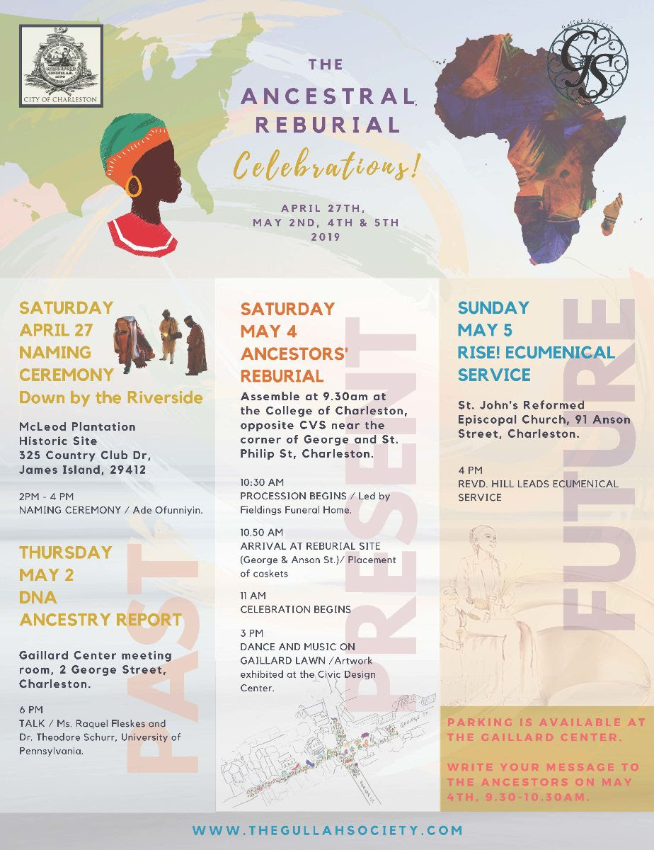
The human remains discovered at the Gaillard Center construction site in February 2013 are returning to an earthly repose this weekend. As celebrations commence to honor those thirty-six people of African descent, let’s review the history of that burial site in search of clues to help us understand who they were and how their final resting place was forgotten.
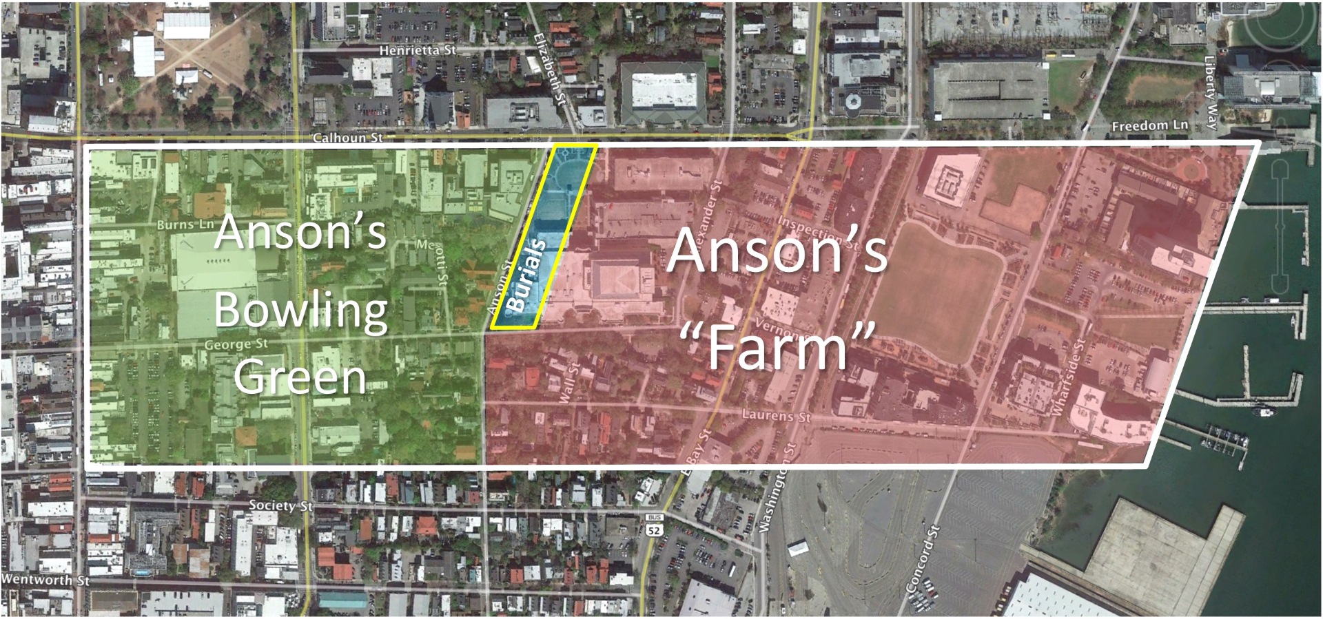
In 2012, the City of Charleston embarked on a large-scale project to expand and renovate the Gaillard Municipal Auditorium. That sprawling building, which opened in 1968, occupied the majority of a block of land bounded by George Street to the south, Anson Street to the west, Calhoun Street to the north, and Alexander Street to the east. On February 5th, 2013, construction workers digging a new foundation on the east side of Anson Street halted their work after noticing bones coming up in the bucket of their digging machine. A quick look at the bones led the workers to suspect they were human remains. As required by law, the foreman notified the City of Charleston Police Department. The police contacted the Charleston County Coroner, who immediately came to the job site. The coroner determined that the remains were indeed human, apparently part of an old burial. This was not a modern crime scene; it was a collection of historical artifacts, and perhaps part of a forgotten cemetery.
The city then contacted Brockington and Associates, a local cultural resource management firm specializing in the investigation of historic landscapes. On February 6th, an archaeological crew from Brockington arrived on the scene and began a systematic exploration. Over the course of a two-week residency, archaeologists carefully excavated the site and identified the buried remains of thirty-six individuals, each oriented on an east-west axis. These were people buried over a period of time within individual graves, all arranged in three or four relatively orderly rows. This was not a mass grave opened for a singular burial event. Archaeologists carefully examined, photographed, and mapped each set of remains in situ, as they were found. Between February 20th and March 1st 2013, a representative from Stuhr Funeral Home worked with the archaeologists to exhume of the skeletal materials and related artifacts. The remains of each individual were placed in his or her own wooden box and transported to a secure storage facility.[1]
Since 2013, the work of studying the Gaillard graves has proceeded along two principal paths—physical and geographical. First, a number of experts have studied each set of the physical remains in order to determine their age, sex, and geographic origin. You can read the details of that scientific analysis elsewhere (on the website of the Gullah Society), so I’ll simply summarize that important work: The group of thirty-six burials includes men, women, adults, and juveniles, some of whom were born in Africa, and some of whom were of African descent but born in the New World. Second, researchers like me at CCPL and from Brockington and Associates have searched for historical documents that might help us understand when and why these people were buried at this particular geographic location.
After six years of searching for historical clues and studying the physical remains, we still don’t know the precise identity of any one of the thirty-six individuals discovered at the Gaillard site, and we probably never will. The discovery of human remains at this location in 2013 was unexpected because the property was not identified as a burial ground in any known document, map, or plat of early Charleston. Either the location of the burial ground was forgotten by later generations of Charlestonians, or the later generations who controlled this site did not value the memory of the people buried there. Those thirty-six individuals of African descent lived in a community that was once deeply committed to the practice of slavery. People like them were considered property that could be bought and sold. Either they endured a life of enslavement here, or formed part of Charleston small but important population of “free persons of color.” If their graves were once marked with names and dates, those markers disappeared long ago. The land was built over with houses, and the memory of the burials evaporated. In order to reconstruct some historical context for the burials, and perhaps find clues that might help us determine the identity and chronology of the individuals buried here, therefore, we have to delve into the history of the ownership of the land. Who held legal control of this property in the distant past, and how did they use it? How can the history of the land help us understand the story of the people buried there?
Prior to the arrival European settlers, the Native American people who inhabited the Carolina Lowcountry changed their residences seasonally—living along the coastline during the warm months and moving several miles inland during the cooler months. If those people occupied this specific site in the distant past, we have not yet found any historical trace of their activities. The English settlers who arrived in this area in the spring of 1670 settled initially on the west bank of the Ashley River, at a place they called Albemarle Point (now Charles Towne Landing State Historic Site). Almost immediately, however, the English newcomers realized that the peninsula of land between the Ashley and Cooper rivers would make an excellent site for a town. By 1672, a handful of families had already established residence on the peninsula they called “Oyster Point,” even before they legally owned the land. In that same year, the colony’s surveyor general laid out a new town at the southern tip of Oyster Point that became “New Charles Town” in 1680. The northern boundary of the town was a line stretching across the peninsula from the Ashley to the Cooper River, which we now call Beaufain Street (and its eastward continuation).
The burial site discovered in 2013 was once part of a large tract of land situated immediately north of the original boundaries of colonial Charles Town. In 1675, the provincial government granted approximately 319 acres on the peninsula to John Coming and Henry Hughes, both of whom had arrived with the first fleet of English settlers. Their joint property encompassed all the real estate between the Ashley and Cooper Rivers, stretching from the town line (Beaufain Street) northward to what is now Calhoun Street. Henry Hughes disappeared from the record books shortly thereafter, and John Coming somehow acquired Hughes’s share of the grant. How he used the property during that early period is unknown. The western half of Coming’s land stayed within his family and later became the neighborhood of Harleston. By the 1690s, however, the eastern half of Coming’s grant found its way into the hands of the Mazyck family.
Isaac Mazyck (1661–1736), a leading member of one of Charleston’s early French Huguenot families, came to South Carolina in late 1686.[2] In the ensuing decades, he acquired a significant amount of real estate in urban Charleston and in the surrounding Lowcountry. Precisely when and how Mazyck acquired the eastern portion of John Coming’s peninsular property is unknown, but he fortified his legal possession of the land in 1696 by applying for and receiving a government grant for ninety acres that represented the same property he already held. In 1707, he obtained an additional grant for seventy-one acres of marsh land bordering on the east side of this property, on the west bank of the Cooper River.[3] This marsh land was later filled to create the site of the present South Carolina Aquarium, the Dockside Condominiums, and Gadsden’s Wharf, among other points of interest along the waterfront.
Whether or not the Mazyck family occupied or used this land is a mystery. Since the family developed working plantations and residences elsewhere, however, it appears that this tract of suburban land might have been a speculative investment property. In the spring of 1710, Isaac Mazyck sold approximately sixty-four acres of this tract to Edward Tynte, South Carolina’s newly-arrived governor. Governor Tynte died three months later, however, and the property conveyance to him was cancelled. From the period encompassing the first fifty years after the founding of English Carolina, we have no surviving documentation of any specific human activity on this site.
In 1720, ten years after the failed conveyance to Edward Tynte, Isaac Mazyck sold the same tract of sixty three or sixty-four acres (as it was then described) to one Thomas Gadsden (1688–1741). Gadsden is a rather mysterious figure in Charleston history who was reputed to have worked in the British Navy or in the merchant marine service before settling in Charleston around 1717. The suburban property he purchased from Mazyck in 1720 included all of the land bounded by what is now King Street to the west, Calhoun Street to the north, the Cooper River to the east, and Society Street to the south. As with the previous owner, we have no surviving documentation of how the Gadsden family used this property, but it appears that they did reside on site.[4]
Legend has it that Thomas Gadsden was a drinker and a gambler, and he lost this property in a card game. These assertions are based on speculative hearsay, however, and are not supported by any surviving historical documents. In fact, the English Parliament adopted a law in 1664 specifically prohibiting the conveyance of real estate to settle gambling debts.[5] Gadsden legally and legitimately conveyed his 63.5 acres in March 1726/7 (on the old Julian Calendar) to George Anson (1697–1762), the thirty-year-old captain of the HMS Scarborough. Anson was assigned by the British Navy to patrol and protect the coastline of South Carolina, and more clues emerge about the use of this land during his residence here.
Captain Anson was based in Charleston for most of the years between June 1724 and May 1735, but he spent at least half of his time at sea. During that period of nearly eleven years, George Anson acquired a substantial amount of real estate in South Carolina, and apparently resided on the suburban tract he purchased from Thomas Gadsden. His residence at this site is confirmed by a document from the spring of 1728, just thirteen months after he acquired it. In a complaint addressed to the Commissioners of Streets for the Parish of St. Philip, Captain Anson stated “that he is seized in fee [that is, held legal possession] of a plantacon [sic] or tract of land with a messuage [dwelling house] and out-houses thereon erected near Charles Towne.” His neighbors to the south, Nicholas Trott and his wife, Sarah Rhett Trott, had recently blocked his customary pathway through their property and into town [probably the present route of East Bay Street], and he wanted it restored.
During George Anson’s tenure at this site, he apparently divided the property into two distinct parcels of roughly equal size. The easternmost parcel, adjacent to the Cooper River and including his residence, Anson simply called “the Farm.” Precisely what he was farming here, and who was doing the labor, is not recorded in any known document. Later references to “Capt. Anson’s pasture,” Anson’s “Orange Grove,” and to “Anson’s old Brew house” suggest, however, that he kept horses, harvested oranges, and produced beer for his crewmen.[7]
The western portion of Anson’s tract, containing just over thirty-nine acres abutting the “Broad Path” (now King Street), he called “the Bowling Green.” In Anson’s day, the phrase “bowling green” was a sort of generic English term for a treeless recreational greenspace, like a sports pitch or field. Newspaper advertisements from the 1730s demonstrate that Anson’s Bowling Green was then Charleston’s most popular site for horse races, wrestling matches, cockfighting, and probably the earliest rounds of golf played in North America.[8]
Captain George Anson sailed out of Charleston harbor in May of 1735 and returned once for a brief visit in 1739. He continued to serve in His Majesty’s Navy, however, and in 1740 was promoted to commodore of a small fleet, under the HMS Centurion, sent to harass the Spanish navy in the Pacific Ocean. When Anson and his skeleton crew returned to England in the summer of 1744 laden with tons of gold, silver, and jewels, he was promoted to the rank of admiral, elected to Parliament, and soon became Lord Anson, Baron of Soberton.[9] Almost immediately, he sent word to his attorney in Charleston, Benjamin Whitaker, to being liquidating his Carolina investments.
In the autumn of 1744, Benjamin Whitaker (1698–1751), chief justice of South Carolina at the time, hired the colony’s surveyor general, George Hunter, to subdivide Anson’s Bowling Green into building lots and streets. The principal east-west street, running through the center of the green, was called George Street, while the principal north-south street, along the eastern edge, was called Anson Street. Three other small streets were named for the ships associated with Anson’s naval career—Scarborough (now part of Anson Street), Squirrel (now part of Meeting Street), and Centurion (now part of Society Street). Hunter completed a plat of his surveying work in early 1745, and advertisements were soon published announcing the sale of lots in the new suburban development called Ansonborough.[10]
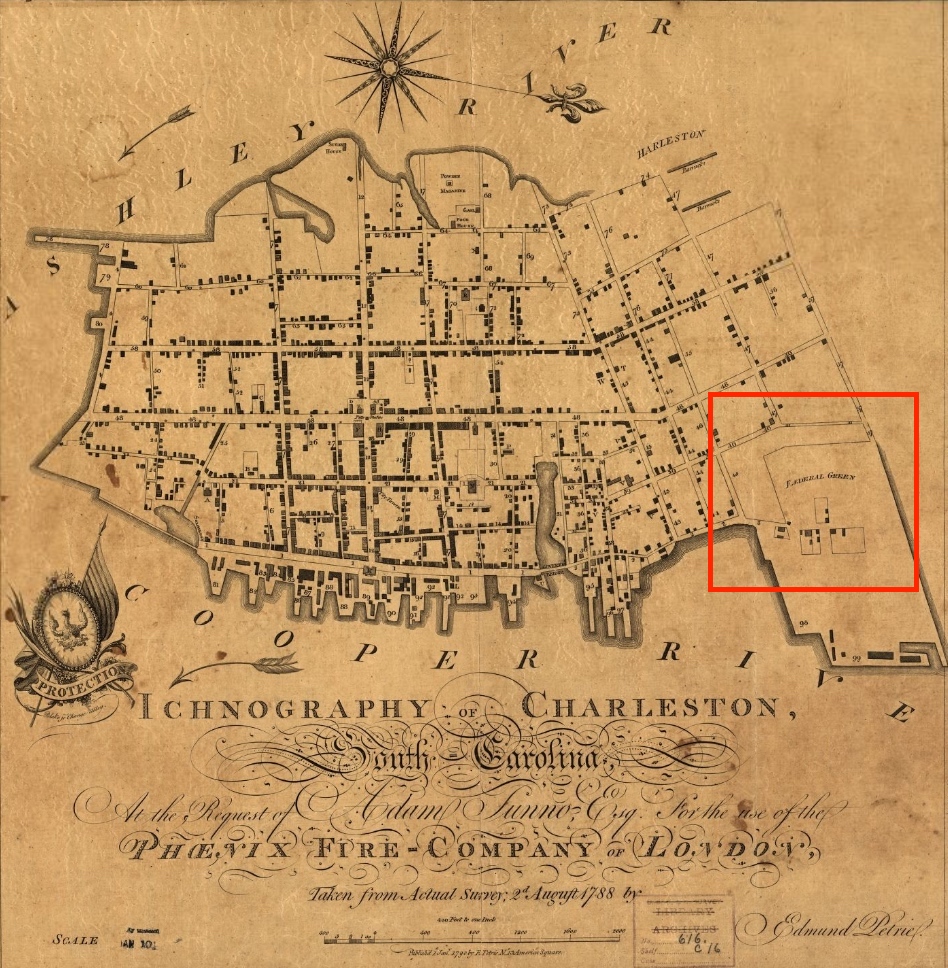
Let’s pause for minute to visualize a few important facts. The original core of Ansonborough, as created in 1745, was located to the west of Anson Street, near the center of the peninsula. The graves discovered in 2013 at the Gaillard Center are located on the east side of Anson Street, however, and were therefore outside of the old Bowling Green. This fact is significant because it provides a clue to the time frame of the earliest burials at this site. In George Hunter’s 1745 subdivision of Ansonborough, the northern end of Anson Street bends slightly to the east because of a tidal inlet that once branched southward from the creek that later became Calhoun Street. That northernmost, bent section of the street was named Scarborough Street, after the ship that George Anson captained when he was first posted in Charleston in the 1720s. The archaeological excavations conducted in 2013 found no evidence that the graves at this site extended further to the west, into Scarborough Street (which is now simply called the northern end of Anson Street). It would appear, therefore, that this street formed the western boundary of the burial site. If this hypothesis seems reasonable, then we might conclude that the burials at this site commenced sometime after the creation of Scarborough Street in 1745. It is possible that the burials commenced before the creation of the street, but we’d have to dig up part of Anson Street to answer that question more definitively. Furthermore, I’ll point out that Scarborough Street is oriented almost precisely on a north-south axis, and is thus almost precisely perpendicular to the adjacent graves discovered in 2013, which were oriented on a roughly-east-west axis. This fact might simply be a coincidence, but, on the other hand, it might be a meaningful clue.
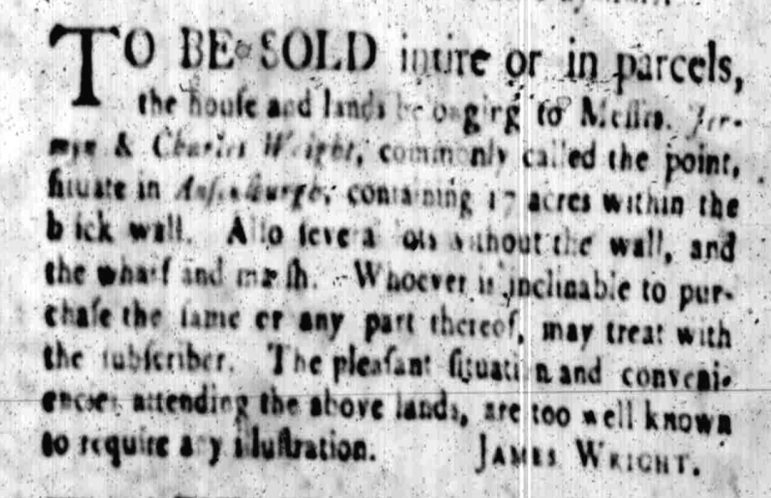
Following the subdivision of the Bowling Green into Ansonborough in the mid-1740s, the other half of Anson’s property remained more or less intact for another decade. In 1747, Anson’s attorney conveyed 23.5 acres of his “Farm,” located between Anson Street and the Cooper River and including the site of the burials discovered in 2013, to Charles and Jermyn Wright. The Wright brothers were wealthy English investors, sons of a former chief justice of South Carolina (Robert Wright, died 1739) and older brothers of the colony’s current attorney general (James Wright, 1716–1785). Their interest in the land was apparently more speculative than practical. That is to say, whether or not they resided on the site, they hoped to profit from the investment by subdividing the property into a number of smaller lots.
When Charles and Jermyn Wright advertised their desire to subdivide “the house and lands” at this site in 1754, they mentioned the availability of building lots on either side of a “brick wall” that stood east of and parallel to Scarborough Street (now the northern end of Anson Street). In a similar advertisement published in 1756, they offered to sell lots only on the west side of the brick wall, each lot measuring 165 feet between the wall and the east side of Scarborough Street.[11] The lots described in this 1756 advertisement included the land containing the burial ground discovered in 2013. Whether or not there were already some bodies buried at this site in 1756 is unknown, but the references to the presence of a brick wall suggests a possible connection.
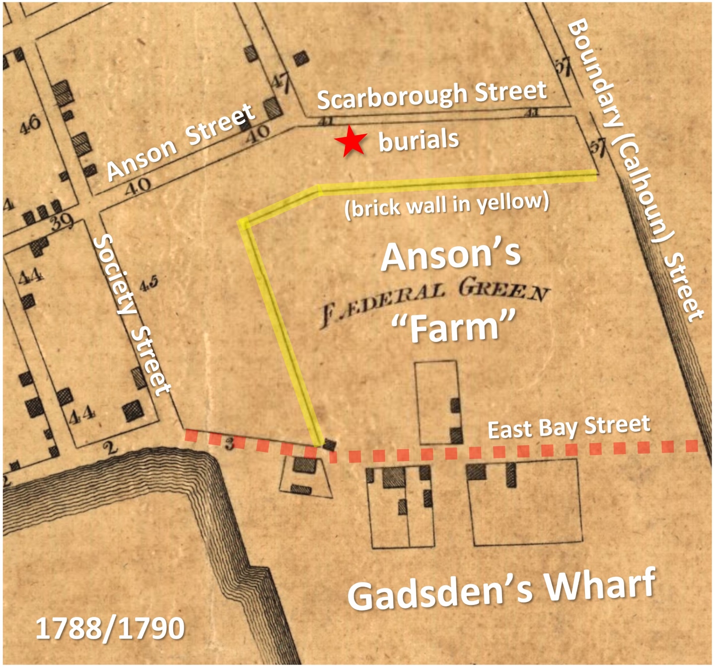
The Wright brothers’ efforts to subdivide the property proved unsuccessful, and in 1756 they re-conveyed the 23.5 acres to Anson’s new Charleston attorney, Richard Lambton. Lambton then sold approximately twenty acres of high land to John Rattray in April 1757, including all of the property located to the east and to the south of an L-shaped brick wall mentioned earlier, all the way down to the edge of the Cooper River. Twelve months later, in April 1758, Rattray conveyed most of this property, including approximately fifteen acres of high land and George Anson’s former residence, to Christopher Gadsden (1724–1805). Gadsden soon developed a massive wharf along the banks of the Cooper River, and, in the years after the American Revolution, subdivided the remaining land in a development called “Federal Green” (which included a “Wall Street”). The remaining four to five acres of Rattray’s property, located north of Society Street, east of Anson Street, and south of the brick wall mentioned earlier, soon became the suburban residence and wharf property of Henry Laurens.
In 1761, sixteen years after commencing to subdivide and sell off parts of his Bowling Green and Farm, George Lord Anson was left holding a balance of approximately three and a quarter acres of high land. This small parcel, which included the site of the graves discovered in 2013, was bounded to the south by John Rattray’s land (soon to be Laurens Street), to the west by Scarborough Street (now part of Anson Street), to the north by a creek that became Calhoun Street, and to the east by the brick wall mentioned in 1754. We have no documentary or physical evidence to confirm that burials had already taken place on this site, but one has to wonder why this small parcel of land was the last remaining undeveloped part of the original much larger tract. By 1761, all of the surrounding lands had been subdivided and sold, and we can now focus our attention on the disposal of this sole remaining lot.
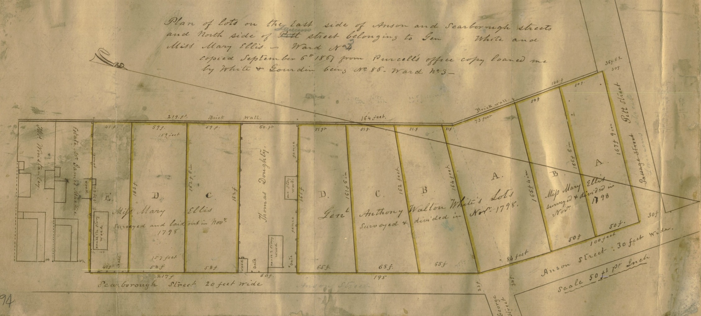
At the beginning of September, 1761, Lord Anson’s local attorney, Richard Lambton, sold the last remaining bit of Anson’s “Farm,” containing three and a quarter acres, to a planter named William Ellis (1726–1772). At some point before October of 1767, Ellis built a residence on the east side of Scarborough (Anson) Street, precisely where George Street now runs.[12] Ellis’s use of the remaining three acres is, so far, unknown. This is unfortunate, because the graves discovered in 2013 were located immediately north of the residence Ellis constructed sometime in the mid-1760s. William Ellis died in December of 1772, and by 1775 his heirs were renting out his house in Ansonborough.[13]
It is unfortunate that we don’t know more about how the land surrounding the burial site was being used in the era of William Ellis, because two physical clues discovered during the 2013 archaeology at this site point to the period immediately following his death. The first is an English half-penny, minted in 1773, which was placed within the grave of an individual buried at this site. The second is a small cannonball that apparently sank deep into the ground here during the American Revolution. These items tell us that the ground, or at least part of it, was not covered by obstructions during the period 1773–1780, and that at least one person was buried here during that time frame. We don’t know who, if anyone, was residing on the property at that time, or how that small tract of approximately three acres was being used.
In the second half of the eighteenth century, William Ellis’s small three-acre tract was a sort of anomaly, separate and distinct from Ansonborough proper to the west and from Christopher Gadsden’s Federal Green to the east. At the turn of the nineteenth century, however, Ellis’s land was homogenized with those larger entities and lost its distinctiveness. It became part of the larger, mostly white residential neighborhood that grew up along this block of Anson, Calhoun, and Wall Streets (located immediately east of the brick wall mentioned in 1754). By the middle of the twentieth century, this neighborhood had transitioned from being mostly white to mostly black, as white urbanites moved to the new suburbs off the peninsula. By the early 1960s, Ansonborough was a predominantly black community with a vibrant family and business life.
In 1965, the City of Charleston moved forward with a plan transform what it considered a “slum” neighborhood into the site of a large municipal auditorium. Following a limited period of community discussion that spring, the city purchased the rights to every parcel of residential property bounded by Anson, Calhoun, and Alexander Streets. All of the houses and business (except 85 Calhoun Street) were demolished or relocated between late 1965 and early 1967. In order to facilitate automobile traffic around the planned auditorium, the city also altered the neighborhood streetscape. George Street, which originally terminated at its intersection with Anson Street, was extended eastward to East Bay Street in 1966. The northern end of Christopher Gadsden’s Wall Street, between George and Calhoun Streets, was obliterated.
Now that we’ve taken tour through the known documentary history of the land containing the Gaillard graves, let’s summarize our best clues. The current consensus is that the thirty-six individuals discovered in 2013 were buried sometime between 1750 and 1800. If the brick wall mentioned by the Wright brothers in 1754 was somehow related to the burials, then it’s possible they commenced a bit earlier. Alternatively, it’s possible that these people were interred sometime between the removal of William Ellis’s residence (perhaps around the time of the American Revolution) and the subdivision of Ellis’s lots in 1798. At the moment, we still don’t have any leads on the identity of the people buried here, nor do we have any clues about who was responsible for burying them, and why they chose this site. As you can see, the documentary evidence is rather thin, but we’ll keep looking for answers.
[1] The archaeological excavation conducted in February 2013 recorded thirty-seven “graves,” but noted that one contained only “small animal bone fragments,” which “may have been a grave where the remains completely decomposed prior to excavation or it was a refuse pit associated with a later occupation of the Gaillard site that was misinterpreted as a grave.” See Eric Poplin to Dustin Clemons, 2 December 2013, page 2.
[2] See Palmer C. Hamilton, “Paul and Isaac Mazÿck: Laying a Foundation in the Midst of Turbulance,” Transactions of the Huguenot Society of South Carolina 116 (2012): 1–40.
[3] The details of the grants to Coming, Hughes, and Mazyck can be found in Henry A. M. Smith, “Charleston and Charleston Neck: The Original Grantees and the Settlements along the Ashley and Cooper Rivers,” South Carolina Historical and Genealogical Magazine 19 (January 1918): 8–10.
[4] E. Stanly Godbold and Robert H. Woody, Christopher Gadsden and the American Revolution (Knoxville: University of Tennessee Press, 1982), 3–21 (chapter one), includes speculative conjecture about the early history of Gadsden family. The original copy of Mazyck’s conveyance to Gadsden is now lost, but it was described in Gadsden’s 1727 conveyance to George Anson and in subsequent conveyances of the same land.
[5] See Charles II, 1664: “An Act against deceitfull disorderly and excessive Gameing,” in Statutes of the Realm: Volume 5, 1628-80, ed. John Raithby (s.l: Great Britain Record Commission, 1819), 523. British History Online, accessed November 6, 2017, http://www.british-history.ac.uk/statutes-realm/vol5/p523.
[6] The original manuscript copy of this this document, dated in April-May 1728, is found among the Records of the Secretary of the Province at the South Carolina Department of Archives and History in Columbia; a typescript transcription can be found in the WPA Transcription volume 76A (1727-1729), 192-93, at the Charleston County Public Library’s South Carolina History Room.
[7] For references to Anson’s land, see South Carolina Gazette, issues of 16–23 June 1739 and 21–28 June 1742. The title “The Farm” appears on George Hunter’s 1745 plat of the subdivision of Ansonborough and subsequent copies of that plat.
[8] For sample references to activities at the Bowling Green (and the tavern there), see South Carolina Gazette, issues of 2–9 February 1733/4; 25 January–1 February 1734/5; 22–29 May 1736; etc.
[9] For further information on Anson’s career, see John Barrow, The Life of George Lord Anson (London: John Murray, 1839), and Glyn Williams, The Prize of All the Oceans: The Dramatic True Story of Commodore Anson’s Voyage Round the World and How He Seized the Spanish Treasure Galleon (New York: Viking Penguin, 2000).
[10] A small collection of papers related to George Hunter’s original survey and plat of the subdivision of Anson’s Bowling Green into Ansonborough, dated January 1744/5 is found at Staffordshire and Stoke-on-Trent Archive Service, Staffordshire Record Office, Records of the Anson Family of Shugborough, Earls of Lichfield, D615/PS/4/4/4. Surviving, later copies of Hunter’s plat uniformly give the date as 1746, however.
[11] South Carolina Gazette, issues of 11–20 June 1754 and 23 December 1756.
[12] See Richard Lambton to William Ellis, 31 August–1 September 1761, Charleston County Register of Deeds, C3: 64–70. Ellis’s new residence blocked Christopher Gadsden’s customary path from his property to Anson Street, so the two men settled the bounds of a new passageway. See Charleston County Register of Deeds, HS: 90–94 (23 October 1767).
[13] The death of William Ellis was announced in the South Carolina Gazette and Country Journal, 29 December 1772. An advertisement in South Carolina American General Gazette, 22 September 1775, offered “to be let and entered on immediately, the large house and lot in Ansonborough, belonging to the estate of the estate of the late Mr. William Ellis. Enquire of David Ramsay.”
[14] The house at 82 Anson street formerly stood at the site of William Ellis’s 1760s house, and was moved one hundred feet to the south in 1967. Known as the “Mary Smith House,” it was built ca. 1799.
PREVIOUS: Abraham the Unstoppable, Part 7
NEXT: The Charleston Riot of 1919
See more from Charleston Time Machine