
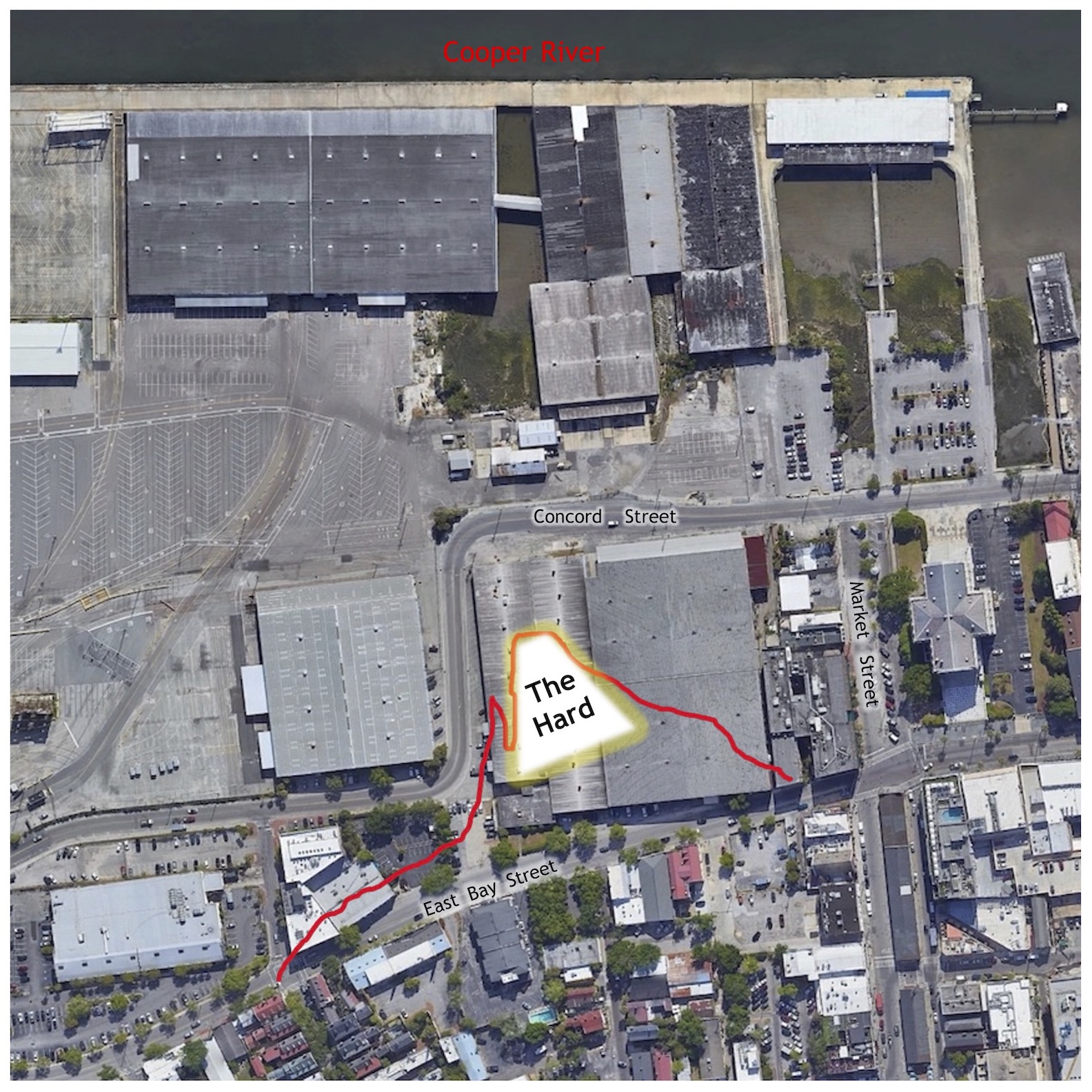
A windowless warehouse on Charleston’s Union Pier conceals a forgotten site of historical significance. Near the present southwest corner of Concord and Pritchard Streets, a projecting point of sand and shells known as “the Hard” or “Rhett’s Point” served as a focal point of maritime activity from the dawn of recorded history in South Carolina to the turn of the nineteenth century. Subsequent wharf construction and landfill obscured the site’s colorful history, but the proposed redevelopment of Union Pier presents an opportunity to revive memories of an important local landmark.
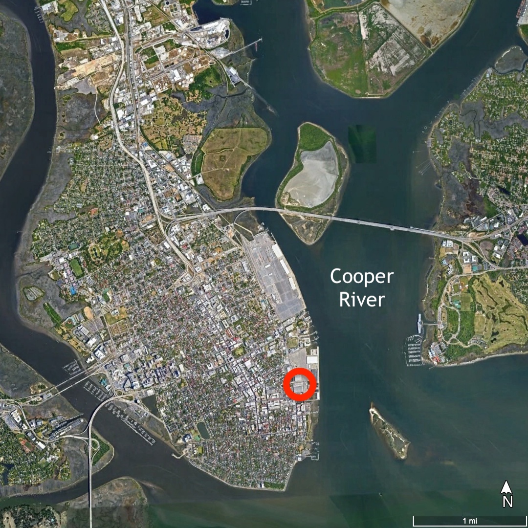
Before it was reshaped by human hands, the Hard was simply a low, wedge-shaped promontory surrounded by marshland, located nearly a mile north of a similar headland once identified as Oyster Point (now the southeastern tip of the Battery). The Hard extended eastwardly into the intertidal zone of the Cooper River along an axis nearly perpendicular to modern East Bay Street. A curving inlet flowing to the northwest facilitated access to the Hard and no doubt attracted the attention of turtles, shorebirds, and ancient humans. The site offered a convenient landing point for watercraft, and likely served as a waypoint for prehistoric Native Americans traversing to and from settlements on modern Daniel Island, Hobcaw Point, and Mount Pleasant. To this day, the shortest and most direct route from the Charleston peninsula across the Cooper River is a line drawn from the Hard to that part of Hog Island now called Patriots Point.

Here, as at dozens of coastal sites across the Lowcountry of South Carolina, generations of Indigenous people might have deposited millions of oyster shells to create a large, circular midden or “shell ring.” Physical evidence of such a structure at the Hard has not yet been found, but its former presence is suggested by the name of a temporary gun battery erected during the American Revolution. British forces occupying Charleston in 1780, likely repeating a phrase used locally, identified the site of a “V”-shaped battery at the east end of Pinckney Street as an “old Indian fort.” That same nomenclature was used elsewhere in the colonial Southeast to describe ancient shell middens misunderstood by European observers. If a shell ring once stood at the Hard, it was likely dismantled by early colonists who distributed the shells to enhance the site’s utility. The earthen ramparts of a gun battery excavated here in 1779–80 would have bristled with embedded oyster shells, which perhaps inspired the re-application of an older placename.[1]
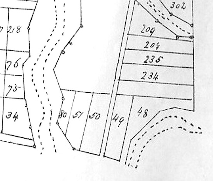
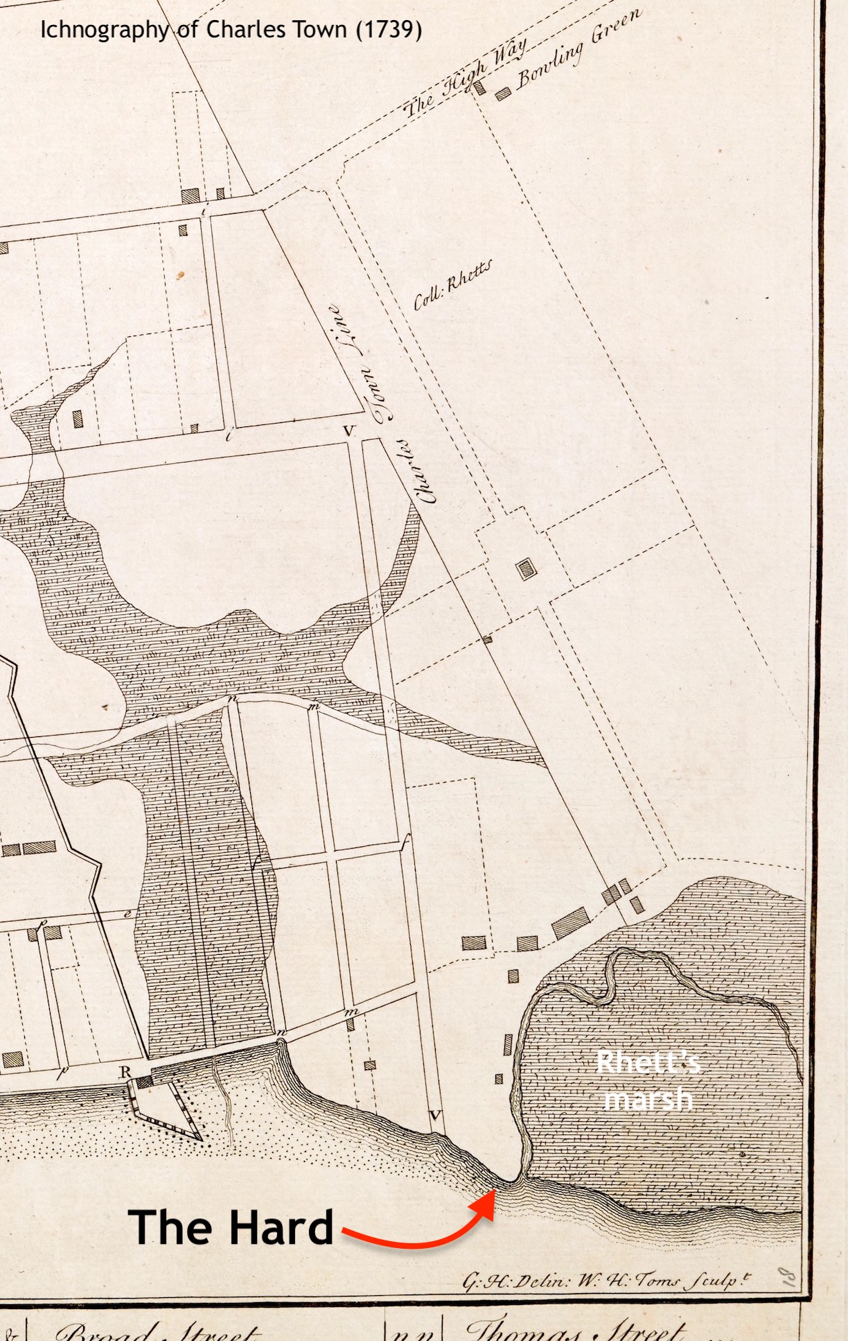
The Hard formed the northeastern-most corner of the 1672 plan or “Grand Model” of Charleston (see Episode No. 245), encompassing the eastern portion of two rectangular, half-acre lots numbered 48 and 49. Maurice Mathews obtained a grant in 1681 for the northernmost lot, No. 48, which benefited from water access on two sides thanks to the aforementioned tidal inlet flowing to the north of the Hard. John Coming, who already owned most of the land to the immediate northwest, received a grant in 1681 for the southern, less valuable half of the Hard, Lot No. 49.[2] Their successors opened a passageway, twelve feet wide, along the boundary line of the two lots, which became known as Hard Alley.
Through a chain of convoluted circumstances at the turn of the eighteenth century, Sarah Cooke Rhett (1665–1745) and William Rhett (1666–1723) acquired the valuable Lot No. 48, along with approximately twenty-five acres of adjacent land formerly belonging to John Coming. From their mansion house, now No. 54 Hasell Street, the couple developed a suburban plantation occasionally called Rhettsbury (see Episode No. 53). Because the waterfront landing at the Hard anchored its business and domestic activities, the property was more generally known as Rhett’s Point. A grant issued in 1714 empowered the Rhetts and their heirs to claim the tidal inlet and acres of marshland immediately north of the Hard. Several present landmarks, including the Harris-Teeter grocery story and the Ansonborough Inn, lie within the boundaries of Rhett’s 1714 marsh grant, which cemented the family’s control of the area for the remainder of the eighteenth century.[3]
To facilitate South Carolina’s import-export commerce during the early 1700s, William Rhett developed a large wharf near the east end of Unity Alley, in the heart of Charleston’s colonial waterfront.[4] That commercial structure, which played an important role in the local economy for many decades, was not the sole focus of Rhett’s work, however. He began his career as a mariner and remained active in the business of ship maintenance for the rest of his life. To accommodate the careening, cleaning, and repair of sailing vessels, Rhett constructed a second wharf at the Hard that extended eastwardly from Lot No. 48 into the Cooper River. On the adjacent high ground, he erected storage sheds, workshops, and other outbuildings to support a thriving maritime industry.
Hundreds of privately-owned vessels probably docked at Rhett’s northern wharf during the first half of the eighteenth century, but few records of that activity survive. Thanks to the trove of maritime records archived by Britain’s Royal Navy, however, we know that several Crown frigates visited the Hard during Rhett’s lifetime. The twenty-four gun Swan, for example, repaired battle-damage and received new masts here in the spring of 1707.[5] The twenty-gun Shoreham offloaded supplies at “Collo. Rhits [sic] store house” before careening at the Hard in June 1716.[6] After the Flamborough careened and victualed at Rhett’s Point in June 1720 without paying, and after the wharf partially collapsed under the weight of the Blandford in March 1722, His Majesty’s warships careened elsewhere for the remainder of the colonial period.[7]
William Rhett served as Comptroller of His Majesty’s Customs for South Carolina during much of his tenure in the colony, but some of his contemporaries alleged that he also dabbled in illegal trade. On several occasions between 1716 and 1722, Rhett was accused of receiving clandestine goods from vessels docked at his industrial wharf at the Hard under the pretense of careening or victualing.[8] Rhett’s death in January 1723 silenced his critics, but other proprietors continued the maritime work he pioneered at the Hard.
Sarah Rhett, widow of the cantankerous colonel, married former South Carolina Chief Justice Nicholas Trott in 1728. Soon afterwards, the couple sold several waterfront lots adjacent to the Hard to carpenters and shipwrights who continued the business of building and repairing vessels at this site for several decades.[9] The number of newly-built vessels launched from the renamed “Trott’s Point” is unknown, but a major hurricane in August 1728 blew one unfinished sloop into the marsh along the northern edge of the Hard.[10] Nearly twenty-five years later, the more memorable hurricane of September 1752 caused another “new vessel” to be “driven off the stocks and wreck’d” at the Hard.[11]

The death of Sarah Rhett Trott in 1745 coincided with a number of changes at her Point property. Months before her passing, the South Carolina General Assembly ratified an act that officially extended East Bay Street northward from Craven Bastion, across a small wooden bridge over Daniel’s Creek (now Market Street), to the residences, workshops, and storehouses at the Hard. A 1744 plat of the new bridge and roadway provides a valuable illustration of the waterfront landscape, but does not depict Rhett’s Wharf extending eastward into the Cooper River.[12] Ownership of the plantation known as Rhettsbury or Trott’s Point passed in 1745 to Sarah Wright (1736–1754), the nine-year-old granddaughter of Sarah and William Rhett. For the next twenty years, young Sarah’s uncle, Thomas Wright (died 1766), served as the resident manager of the site’s various maritime activities.
Thomas Wright employed an assistant to “look after a timber yard on the Hard” in the 1750s.[13] One John Smith, who likely held that position as early as 1747, reminded customers via the South Carolina Gazette that anyone landing goods “at the Point Wharf” was obliged to pay for the privilege immediately, as were the owners or carpenters of “all vessels and boats that make use of any part of the said old wharf, to clean, burn, &c.” Smith also mentioned that anyone wanting to cross the Cooper River to Daniel Island or Hobcaw Point would “find a sure passage at any time of the day, a canow [sic] being kept ready for that purpose at Rhett’s Point or the Hard.”[14] Thomas Wright himself advertised in 1748 that he charged twenty shillings for “any open pettiaguas [sic] or boats to be graved or repaired,” and forty shillings “for every decked schooner.”[15]
The hurricane of 1752 likely demolished the remainder of William Rhett’s old wooden wharf.[16] By that time, additions of pilings, oyster shells, and ballast stones had reshaped the topography of the Hard. Thomas Wright suggested as much in 1757 when he complained about the effects of sustained maritime traffic at the site. “For some time past,” said Wright, “many vessels and boats are graved and repaired at Trott’s point, called the Hard, and many large masts and spars are hauled up and made thereon, whereby much damage has been done to the land by ship carpenters, vessels, and boats.” To establish a more orderly work site henceforth, Wright published a detailed schedule of fees and notified “all ship carpenters, and owners of vessels, or boats . . . that payment will be required for all use made of the Hard, and for landing all timber, planks, lime, bricks, &c according to the prices hereunder mentioned.”[17]

Wright’s 1757 list enumerates his fees for the cleaning, graving, and repairing of sloops, schooners (decked and undecked), flats, lime boats, pilot boats, canoes (large and small), yawls, and “pleasure boats.” It also fixes the prices of masts (large, medium and small), topmasts, bowsprits, and booms, and his charges for landing bulk quantities of firewood, bark, bricks, lime derived from burnt oyster shells, and dimensional lumber deposited at the Hard. Wright continued to advertise a variety of lumber and building materials into the 1760s, include the tar, pitch, oil, paint, and other supplies used in ship maintenance.[18] These sources provide a valuable snapshot of life at the Hard, where generations of enslaved ship carpenters lived and worked within an evolving and increasingly industrial landscape.
Thomas Wright began his career at the Hard as a manager for his young niece, Sarah Wright, who in 1750, at the age of fourteen, married James Hasell Jr. (1727–1769) of North Carolina. Following Sarah’s death at the age of eighteen, Thomas purchased a small lot at the heart of the Hard from Mr. Hasell and managed the property for his own profit during the last decade of his life. In 1765, shortly before his death, Wright advertised to lease his “brick house on the Hard” and “all the benefit and profit arising from vessels, scooners [sic], and boats graving, repairing and building on the Hard, and for bricks, lime and lumber landed.” He described the site as “a very convenient place to keep a timber yard” and “a proper place to keep a ferry” across the Cooper River.[19] In his last will and testament, Wright bequeathed the Hard property to his teenage grand-nieces, Susannah Hasell (1752–1812) and Mary Hasell (1753–1794).
While the widow of Thomas Wright occupied the site until her death, shipwrights like William Tweed, William Harper, George Noddings, and others worked at the Hard in the late 1760s and early 1770s.[20] During that same era, vintners like Vivien Lochon, John Mortimer Williams, and William Davis operated taverns at or near the Hard that entertained workers and customers waiting for small ferry boats to row them across the Cooper River.[21]
The continued maintenance of larger vessels at this location is confirmed by a mishap that occurred in the summer of 1773. On June 8th of that year, the slave ship Edward arrived in Charleston Harbor directly from Africa. After performing the mandatory ten-day quarantine in the harbor, the ship’s cargo of “one hundred and eighty young, healthy, Whydah Negroes” was sold on the deck on June 17th. The empty vessel then moved upstream in the Cooper River to undergo routine maintenance before sailing back to Liverpool. While careening at the Hard, the ship apparently heeled too far along its longitudinal axis, took on water, and sank in the shallow stream. The vessel was “weighed up again” shortly afterwards, however, and sailed for England in early August.[22]
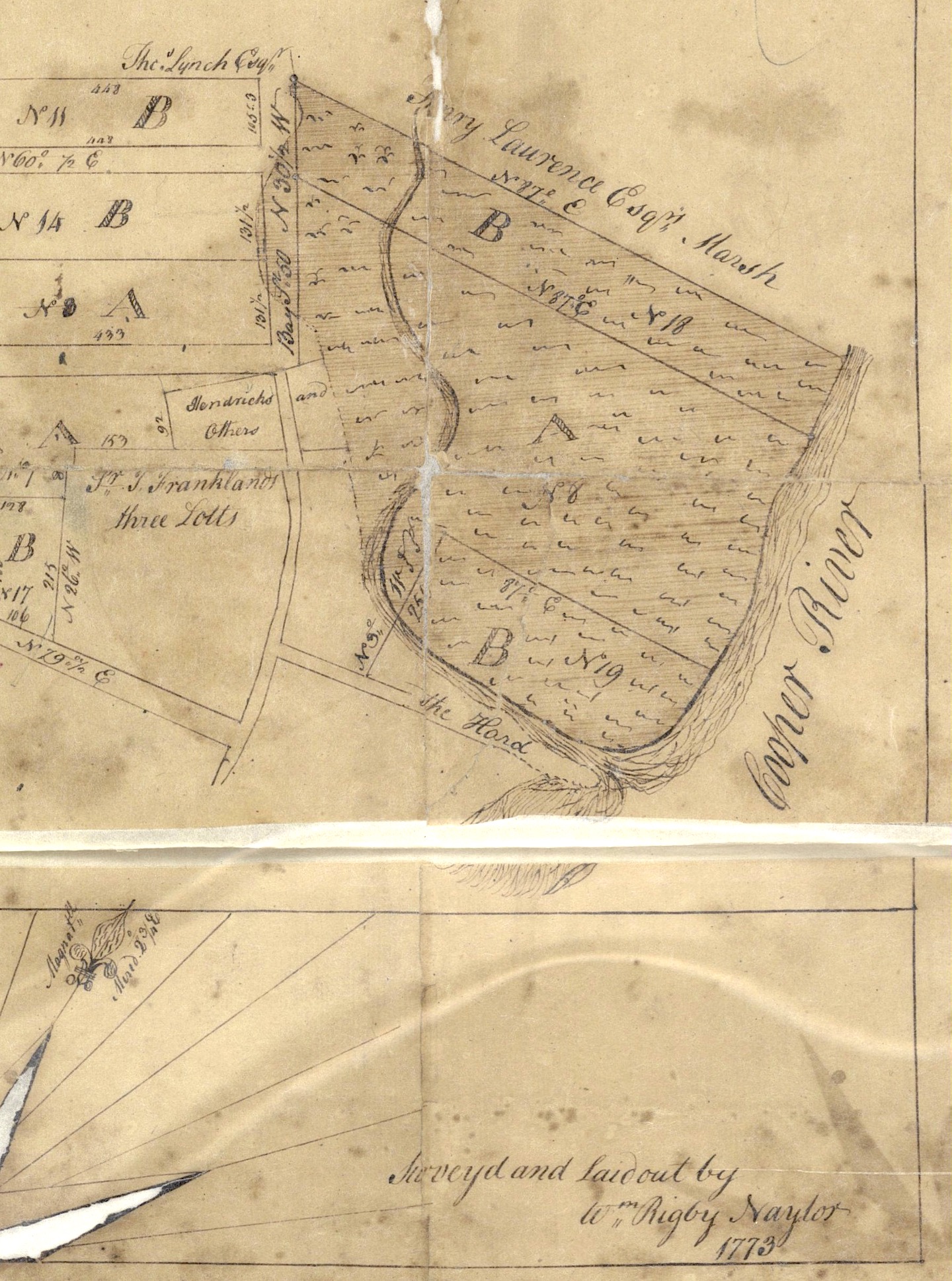
Maritime activity at the Hard continued under a series of proprietors with relatively little change from the death of William Rhett in 1723 until late 1773. That autumn, the Court of Common Pleas divided the plantation known as Rhettsbury or Trott’s Point between Rhett’s adult great-granddaughters, Susannah Hasell Quince and Mary Hasell Anrcum of North Carolina, who also inherited the Hard from their great-uncle, Thomas Wright.[23] The court-ordered partition of the old Rhett plantation awarded the Hard, as well as the adjacent inlet and marshland, to Mary Ancrum, who afterwards became Mary Ancrum Grainger McCalister.

Commercial activity at the Hard declined during the tumultuous years of the American Revolution. In the post-war 1780s, new proprietors to the south of Rhett’s Point began reshaping their land to maximize its utility. The southern edge of the Hard had long hosted maritime activity in the shadow of the Rhett family heirs, but the new neighbors now took the lead. By 1787, for example, merchant Florian Charles Mey acquired the eastern half of Grand Model Lot No. 49 and erected a long wooden wharf that extended farther into the Cooper River than the property of his immediate neighbors. Suddenly and for the first time, the topographical advantages of the Hard were overshadowed by nearby human construction. Although Mary McCalister obtained a grant from the state government in 1787 empowering her to extend her property rights farther eastward, just like Mr. Mey, she made no further investments in the Hard before her death in 1794.[24]
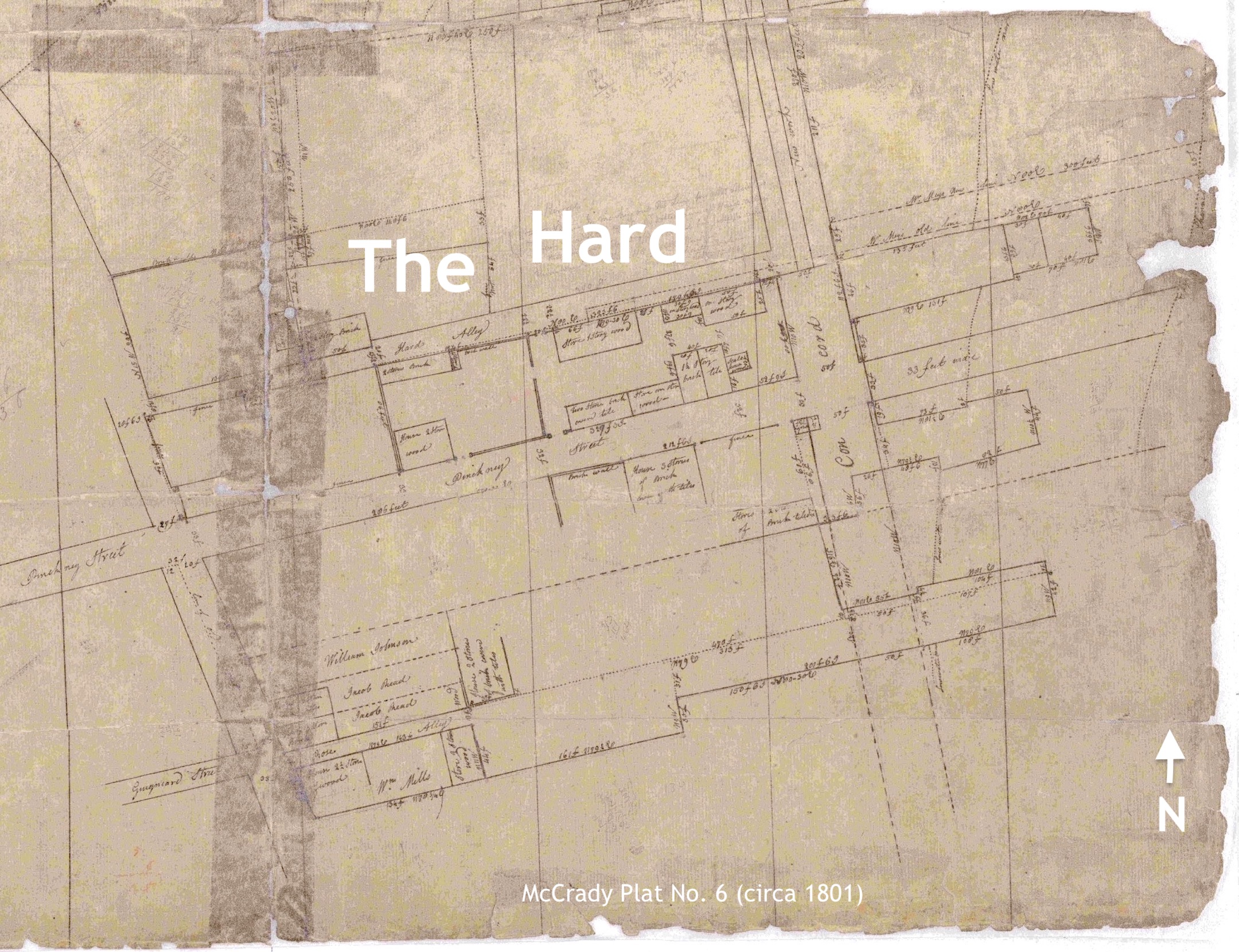
In November 1800, Mary’s son James Hasell Ancrum sold a “parcel of land distinguished and known by the name of the Hard” to a pair of prosperous ship carpenters, William Pritchard and son.[25] Booming exports of South Carolina cotton at turn of the nineteenth century triggered a profusion of wharf construction to the north, south, and east of the Hard that reached farther into the Cooper River. When the Pritchards agreed with their southern neighbor, Florian Charles Mey, and northern neighbor, Philip Gadsden, to create Concord Street through the eastern edge of their respective properties in 1801, they jointly widened Hard Alley to twenty feet and ceded it to the City of Charleston as a public thoroughfare.[26]
The Pritchards erected a long wooden wharf in the early 1800s that extended their commercial reach farther into the Cooper River, but their work did not immediately entomb the natural topography of the Hard. The headland of sand and shells, now on the west side of Concord Street, remained visible and washed by the daily tides into the 1820s. William Pritchard the elder subdivided the Hard in 1823 into eleven residential lots bounded by Hard Alley, East Bay, Pritchard, and Concord Streets, but the water-logged property attracted only commercial developers.[27]
Maritime activity around the now-landlocked Hard continued to expand during the remainder of the nineteenth century, dominated by the erection of large cotton warehouses owned by the Union Cotton Compress Company (the nucleus of the present Union Pier). Their successors, the Charleston Terminal Company, usurped Hard Alley in late 1905 and triggered a protracted dispute with City Council about the unauthorized obliteration of a longstanding public right-of-way. Four years later, the city agreed to close the colonial-era passageway in exchange for a strip of land to widen nearby Pritchard Street to its present breadth.[28]
The City of Charleston purchased the former Hard and numerous other Cooper River waterfront properties in 1921 to create the Port Utilities Commission, hoping to better manage the privately-owned wharves that had languished for decades after the Civil War. The economic decline caused by the Great Depression, and the rapid growth of the North Charleston Navy Base, foiled the city’s hopes of managing a modern public waterfront, however. In 1947, the municipal Port Utilities Commission transferred ownership of their extensive portfolio of docks and wharves to the recently-created South Carolina Ports Authority (SCPA).
The State Ports Authority’s large-scale expansion of Union Pier over the course of the twentieth century supplanted maritime traditions established at the Hard generations earlier and erased its physical vestiges. Despite these changes, documentary evidence of the site’s early history preserves an important story: The natural topography of the Hard formed the nucleus of a vibrant cultural landscape that evolved over three and a half centuries into the present Union Pier. To acknowledge the site’s deep and diverse legacy, references to the Hard merit inclusion in plans for its post-industrial future.
[1] See “The Investiture of Charleston, S.C. by the English Army, in 1780. With the Position of Each Corps,” a hand colored manuscript map held by the Library of Congress Geography and Map Division (permalink: https://lccn.loc.gov/gm71000638). This manuscript map appears to have been the model for Joseph F. W. Des Barres’s printed map, A Sketch of the Operations before Charlestown (London, 1780), also held by the Library of Congress (permalink: https://lccn.loc.gov/gm71000644).
[2] Susan Baldwin Bates and Harriott Cheves Leland, Proprietary Records of South Carolina, Volume Three: Abstracts of the Records of the Surveyor General of the Province, Charles Towne 1678–1698 (Charleston, S.C.: History Press, 2007), 54, 151.
[3] South Carolina Department of Archives and History (hereafter SCDAH), Register and Secretary of the Province, Book K (1714–19), 402. A rudimentary illustration of the acreage in question can be seen in plat No. 163 and No. 6169 in the John McCrady Plat Collection, Charleston County Register of Deeds Office (hereafter CCRD).
[4] Rhett’s wharf near the east end of Unity Alley was one of two wharves in urban Charleston depicted in the so-called “Crisp Map” of 1711.
[5] See Captain’s log, HMS Swan, ADM 51/957; Captain Henry Blinston to the Navy Board, 22 April 1707, ADM 106/616/201; William Rhett to the Navy Board, 3 April 1721, ADM 106/743/216; Captain’s log, HMS Blandford, 1721–24, ADM 51/4126; all held at the National Archives, Kew.
[6] See Master’s log, HMS Shoreham, 1715–18, ADM 52/298; William Rhett to the Navy Board, 3 April 1721, ADM 106/743/216; both held at the National Archives, Kew.
[7] Captain’s log, HMS Flamborough, 1716–21, ADM 51/357; William Rhett to the Navy Board, 3 April 1721, ADM 106/743/216; both held at the National Archives, Kew. For more information about careening in the South Carolina Lowcountry, see Episode No. 239.
[8] See Gov. James Moore and Council to Joseph Boone, 19 January 1720/1, CO 5/358, National Archives, Kew; Anonymous, An Apology or Vindication of F. Nicholson, His Majesty’s Governor of South Carolina, From the Unjust Aspersions Cast On Him By Some of the Members of the Bahama Company (London: T. Payne, 1724), 5–15, 22–49.
[9] At some point before 1734, the Trotts sold three small lots, located near the southeast corner of modern East Bay and Hasell Streets, to shipwright John Scott, carpenter Experience Howard, and planter William Hendrick; see Nicholas Trott and Sarah, his wife, to Rev. Alexander Garden and Joseph Wragg, lease and release in trust, 16–17 April 1734, Charleston County Register of Deeds, book OO: 279–91. Their work at this site was continued by other later proprietors mentioned in later deeds and newspaper notices. Shipwright John Yerworth, for example, advertised his presence at “Mrs. Trott’s Point” in SCG, 9–16 April 1741, page 3, but nothing is known of his tenure there.
[10] The hurricane occurred on 2 August 1728 and was described in the [Boston] New England Weekly Journal, 21 October 1728, page 2.
[11] South Carolina Gazette (hereafter SCG), 19 September 1752, page 2. The vessel in question was wrecked “at Mr. Wright’s.” This was Thomas Wright, whose tenure at the Hard is discussed below.
[12] Act No. 719, “An Act for confirming and establishing a public Street from the North Bounds of Charles Town, to the North End of the Bay of the said Town; and for building a Bridge over the Marsh at the North End of the said Bay, and assessing the Lands and Improvements of the several Persons therein named towards defraying the Expence of the same,” ratified on 29 May 1744, found among the engrossed copies of Acts of Assembly at the South Carolina Department of Archives and History.
[13] SCG, 11–18 August 1759, page 6.
[14] SCG, 3–10 August 1747, page 3; SCG, 19–26 October 1747, page 3.
[15] SCG, 16–25 July 1748, page 3.
[16] Charles Blaskowitz’s 1780 “Plan of the Siege & Surrender of Charlestown South Carolina,” MPH 1/666/1 at the National Archives, Kew, depicts a long rectangle of dots (pilings) extending eastwardly from the Hard into the Cooper River. This feature likely represents the remnants of William Rhett’s earlier wharf.
[17] Wright’s notice first appeared in SCG, 7 July 1757, page 3, and was reprinted in several subsequent issues.
[18] SCG, 1–8 March 1760, page 2; SCG, 12–19 December 1761, page 2; SCG, 25 June–2 July 1763, page 2; SCG, 25 February–3 March 1764, page 1; SCG, 8–15 June 1765, page 2; SCG, 14–21 September 1765, page 1.
[19] SCG, 13–20 April 1765, page 2; A conveyance from James Hasell Jr. to Thomas Wright has not yet been found, but Wright mentioned his purchase of the Hard in his will, dated 8 January 1766; proved on 15 May 1766; recorded in SCDAH, Will Book 1767–71, page 127; WPA transcription volume 11A (1767–1771), 203–6.
[20] SCG, 18 July 1768, page 6; South Carolina and American General Gazette, (hereafter SCAGG), 16–26 March 1770, page 1; SCG, 22 August 1771, page 2; SCAGG, 6–12 February 1772, page 2.
[21] Vivien Lochon or Loschon was a licensed retailer of spiritous liquors (see SCG, 24 April–1 May 1762, page 5), who also sold “canows” and oars at the Hard; see SCG, 16–23 May 1761, page 1; SCG, 27 June–4 July 1761, page 1; SCG, 12–19 June 1762, page 1; SCG, 25 June–2 July 1763, page 1; for the other men, see SCG, 17 October 1771, page 3; SCAGG, 16–23 March 1772, page 3; South Carolina Gazette and Country Journal, 16 November 1773, page 3.
[22] SCG, 14 June 1773 (Monday), pages 1 and 3; South Carolina Gazette and Country Journal (hereafter SCGCJ), 22 June 1773, page 2; SCG, 28 June 1773, page 3; SCG, 5 July 1773, page 5; SCGCJ, 27 July 1773, page 2; SCGCJ, 10 August 1773, pages 3–4. This vessel and cargo are identified as voyage number 91626 in the trans-Atlantic database at slavevoyages.org.
[23] Several later conveyances refer to a writ of partition confirmed by the Court of Common Pleas for Charleston District on 18 September 1773, but that document has not yet been found. The background of the case is recited, however, in Parker Quince and Susannah, his wife, to John Davis, lease and release, 29–30 December 1773, CCRD, I4: 187–202, which includes a copy of the plat of division made by Rigby Naylor. An 1801 copy of Naylor’s plat, now identified plat No. 3614 of the John McCrady Plat Collection, held by CCRD, indicates that Naylor’s plat was dated 2 September 1773.
[24] See Joseph Purcell’s July 1787 illustration of Mey’s Wharf, now identified as Plat No. 209 in the John McCrady Plat Collection held by CCRD. For the grant of low-water property to Mary McCalester [sic] on 17 September 1787, see SCDAH, State Plat Books (Charleston Series, S213190), volume 20, page 288.
[25] James Hasell Ancrum to William Pritchard Sr. and William Pritchard Jr, release, 22 November 1800, CCRD D7: 92–93.
[26] Florian Charles Mey (merchant), William Pritchard Senior (ship carpenter), William Pritchard Junior (ship carpenter), and Philip Gadsden (factor), to the City Council of Charleston, release, renunciation of dower, and plat, 7 December 1801, CCRD G7: 47–50.
[27] See the plat annexed to William Pritchard senior to William Pritchard junior, release and conveyance in fee, 2 January 1804, CCRD Y7: 74–76; the elder Pritchard advertised to sell “one lot of land, formerly called the Hard,” in 1805; see Charleston City Gazette, 25 June 1805; Pritchard’s October 1823 subdivision of the Hard, illustrated in McCrady Plat No. 3570, depicts “11 lots of land mostly covered at half tide.”
[28] City Council proceedings of 24 October 1905, published in Charleston Evening Post, 26 October 1905, page 2; Evening Post, 27 December 1905, page 5, “Must Improve Depots at Once”; Charleston News and Courier, 1 June 1906, page 10, “Who Owns the Streets?”; News and Courier, 5 June 1906, page 10, “Thought it was Theirs”; News and Courier, 8 June 1906, page 3, “Hard Alley Now Famous”; News and Courier, 9 June 1906, page 10, “Hard Alley—A Proposition”; City Council proceedings of 12 June 1906, published in News and Courier, 14 June 1906, page 7; City Council proceedings of 10 November 1908, published in News and Courier, 13 November 1908, page 8; City Council proceedings of 22 December 1908, published in News and Courier, 25 December 1908, page 7; City Council proceedings of 12 January 1909, published in Evening Post, 14 January 1909, page 8; News and Courier, 1 December 1909, page 3, “Transfers of Realty.”
NEXT: William Ah Sang and the Chinese Question of 1869
PREVIOUSLY: The Genesis of North Charleston's Oldest and Newest Library
See more from Charleston Time Machine