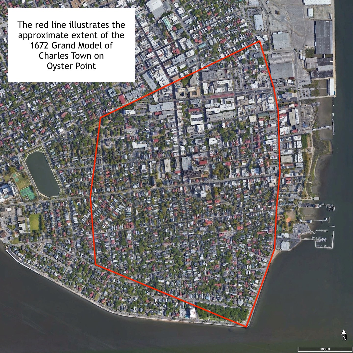
How did a maritime forest between the rivers Ashley and Cooper become the urban streetscape we call Charleston? The spark of this long transformation occurred in 1672, when South Carolina’s Surveyor General drew a plan for a town on the verdant peninsula called Oyster Point. Although John Culpeper’s “model” of the town was imperfectly inscribed on the forested landscape, the grid of streets and lots created 350 years ago framed the growth of Charleston and continue to shape the way residents and visitors experience the Palmetto City in the twenty-first century.
Historians use the phrase “Grand Model” to describe the original plan for a town at Oyster Point that became “New Charles Town” in 1680.[1] The plan included approximately 350 lots and a grid of nearly a dozen unnamed streets arrayed over the southernmost portion of the peninsula, bounded on the southwest by the Ashley River, on the southeast by the Cooper River, and bounded on the north by an imaginary line running through the center of modern Beaufain Street and continuing eastward to the Cooper River. The Grand Model is an important document and concept in the early history of both Charleston and South Carolina. Any conversation about the early physical and cultural landscape of the city inevitably refers to some facet of the Grand Model, and the colonial-era plan set a precedent for subsequent town planning across South Carolina. In short, the story of the creation and execution of the Grand Model is required reading for everyone who enjoys walking the centuries-old streets of Charleston.
Prelude to the Town Plan:
The Grand Model was the culmination of two years of experience within the first English settlement in South Carolina, which commenced in April 1670 on the west side of the Ashley River. At a place they called Albemarle Point, the first colonists constructed shelters, defensive fortifications, and laid out gardens for a community they called Charles Town. The Lords Proprietors of Carolina, who owned the colony and had financed the expedition from London, expressed disappointment with the geographic limitations of the initial town site and its lack of formal planning. In several letters written during 1670 and 1671, the Proprietors directed Governor William Sayle and other officials to seek a larger, healthier site for a future town that could serve as the principal port and capital town of South Carolina. At some point between his arrival in April 1670 and his death in March 1671, Governor Sayle informally reserved the southernmost part of the peninsula between the rivers Ashley and Cooper, then known as Oyster Point, as a potential site for a future port town. Contemporaries estimated that the site in question contained approximately six hundred acres—a figure that proved to be approximately fifty percent higher than the actual acreage.[2]
In letters sent to South Carolina in 1671 and 1672, the Lords Proprietors in England reiterated their desire that the settlers should establish a proper port town. They included several specifications, crafted principally by Lord Anthony Ashley Cooper and his secretary, philosopher John Locke, regarding the dimensions and physical arrangement of an ideal community. This trans-Atlantic conversation was part of a larger, utopian dream envisioned by Ashley and Locke, which they described as the “Grand Model” for a new social hierarchy within the Carolina Colony.[3] Most of their lofty ideals proved impractical in the frontier wilderness, but the Proprietors’ manifest their civic ideals in a scaled drawing sent in 1671. “When ye place for ye town is chosen by those who are to dwell in it,” wrote the Proprietors that May, “ye surveyor shall lay out streets according to ye model herewith sent[,] as near as ye particular scituation of ye place will admit.” The “model” in question does not survive, but a brief contemporary description of it, written by John Locke, provides invaluable details.
The Proprietors desired the individual lots of their ideal town to stretch between two streets, with each house facing a “front street” and having a rear “outlet” to the “next street behind.” This description seems to indicate a preference for the long, narrow “burgage plots” that characterized the traditional English towns and villages laid out in Medieval times. Rather than constraining these burgage lots to a linear “high street,” as found in English towns, the proposed town lots of South Carolina were to fill blocks of land within a perpendicular grid of streets and alleys. The notes of John Locke indicate that the Proprietors (or perhaps just Lord Ashley) desired the town’s graduated streets to range in breadth from eighty to thirty feet, dividing the town into “squares” measuring six hundred feet on each side. The desired port town was also to include a vacant space eighty feet wide along the river front, “for a wharfe for ye publick use of ye towne.” A reservation of two hundred acres adjacent to the town was to provide a “common” for planting and pasturage. Finally, the ideal town was to include a “high way” connecting it to the neighboring plantations and future towns created within the colony.[4]
Lord Ashley revised his ideal dimensions in September 1671, when he suggested that the proposed town include “six score [i.e., 120] squares of 300 foot each to be divided one from the other by streets and alleys.”[5] In June 1672, the Lords Proprietors repeated their expectation that “the people shall plant [that is, settle] in townes w[hi]ch are to be laid out into large, straight & regular streets, and sufficient roome left for a wharfe if it be upon a navigable river.”[6] South Carolina’s provincial government signaled their intention to fulfill such instructions in January 1672 by resolving to establish a town on the Oyster Point peninsula reserved earlier by Governor Sayle, encompassing all of the land to the south of a marked tree. In a letter to Lord Ashley, provincial secretary Joseph Dalton described that site as the key point of the surrounding landscape within Charleston Harbor.[7] As I described in Episode No. 244, the government likely paid the Etiwan Indians at this time to remove from the peninsula to the land on the northwest side of the Cooper River.
On the 21st of February 1672, John Coming and his wife, Affra, and Henry Hughes, appeared before the Grand Council of South Carolina with a proposition. They had already staked a claim to several hundred acres immediately north of the marked tree, stretching across the peninsula from the Ashley to the Cooper River, and other settlers had staked similar claims to the land to their north. Coming and Hughes offered to give the southernmost half of their claim—approximately 150 acres—to the government, for use as a common for the proposed town at Oyster Point.[8] The members of South Carolina’s Grand Council accepted this offer, but nothing was done immediately. After a delay of several months, during which time the Etiwan might have removed from their traditional habitations, the provincial government began to move toward the formal creation of it first large town.
On the 27th of July, 1672, Governor John Yeamans issued a warrant directing the surveyor general, John Culpeper, “to admeasure and lay out for a Towne on the Oyster Poynt all that poynt of land there formerly allotted for the same [by Governor Sayle],” to the south of “a marked tree formerly designed to direct the bounding line of the said towne to the south.” Along the northern edge of the reserved land, immediately to the north of the marked tree, Culpeper was to add approximately 150 acres of the land across the breadth of the peninsula “formerly marked to be layd out for Mr. Henry Hughes, Mr. John Coming and Affera his wife, and James Robinson,” which was to serve as the town’s common. The two tracts were estimated to encompass a total of seven hundred acres. On the same day, the governor issued additional warrants instructing the surveyor general to measure the lands immediately north of the town, claimed by a John Coming, Henry Hughes, and a succession of other settlers up the remaining part of the peninsula. This was the beginning of the formalization of informal claims made sometime earlier.[9]
Surveying the Landscape:
The task of creating a town plan fell to John Culpeper, South Carolina’s Surveyor General, but he likely incorporated suggestions from the colony’s senior officials. During the spring or summer of 1672, Governor Yeamans and the Grand Council of South Carolina probably shared with Mr. Culpeper the several letters from the Lords Proprietors expressing their desires for the colony’s future port town. We don’t know for certain that Culpeper reviewed these documents, but we do know that he ignored the various dimensions articulated therein. The generous specifications from the Proprietors anticipated the selection of a large, homogenous landscape bordering a navigable river, which proved impractical in the low-lying coastal landscape occupied by the early settlers of South Carolina. John Culpeper’s 1672 plan rejected the letter of the “model” sent by the Proprietors in 1671, but embraced the spirit of their recommendations.
Before creating a realistic plan for the proposed town at Oyster Point, Culpeper had to develop an understanding of the site’s general characteristics. Such work required him to walk the length and breadth of the forested peninsula to identify the boundaries between high land and marshland—at both high and low tides—to determine how much of the available real estate was suitable for human occupation. In his preliminary work on this project, Culpeper probably collected sufficient data and measurements to draw an outline of the high land on the peninsula, stretching from the southern tip of Oyster Point to the marked tree standing nearly three-quarters of a mile to the north, and from the banks of the Cooper River westward nearly two-thirds of a mile to the sprawling marshland of the Ashley River. That area encompassed approximately three hundred acres, a significantly smaller quantity of land than previously estimated.
Culpeper’s outline of the habitable land at the southern tip of Oyster Point embraced a sandy, arrow-like point to the south, leading to a meandering line of high land along the eastern shore fronting the Cooper River. The northern boundary was a straight line across the peninsula from the Cooper to the Ashley River that now forms the center line of modern Beaufain Street (created in 1769–70).[10] Along the western frontier, the boundary line followed the edge of highland against the marsh of the Ashley River, marked roughly today by modern Wilson and Franklin Streets, part of Savage Street, and Council Street.[11] The plan also embraced some questionable terrain around the southwestern tip of the peninsula that was underwater at high tide, between modern Council Street and the southeastern point of White Point Garden. Culpeper’s inclusion of such property seems to indicate that he and his contemporaries envisioned future occupants filling, raising, and improving their property to render it safe from the incursion of the tides. In short, this was not an ideal site for a town, but it was the best site that the early English settlers could identify in the vicinity.
Designing a Scale Model of the Town:
Because Culpeper’s generation relied heavily on maritime travel, the proposed town at Oyster Point required a commodious landing or quay for ships, cargo, and passengers. A survey of the available landscape and water depth around the peninsula revealed a logical choice for the required landing—a nearly straight line of high land fronting the Cooper River between two former creeks known today as Water Street and Market Street. This half-mile stretch of waterfront (now part of East Bay Street) probably formed the starting point for Culpeper’s scaled drawing of the town plan.[12] From a point at the center of this Cooper River landing, the surveyor drew a broad, perpendicular street extending westward to the Ashley River that was destined to become the town’s principal east-west thoroughfare (now Broad Street). Near the center of the available high ground between the two rivers, Culpeper drew a second street of the same breadth, perpendicular to the capital street, that was destined to become the town’s principal north-south thoroughfare and “high way” connecting it to the countryside (now Meeting Street).
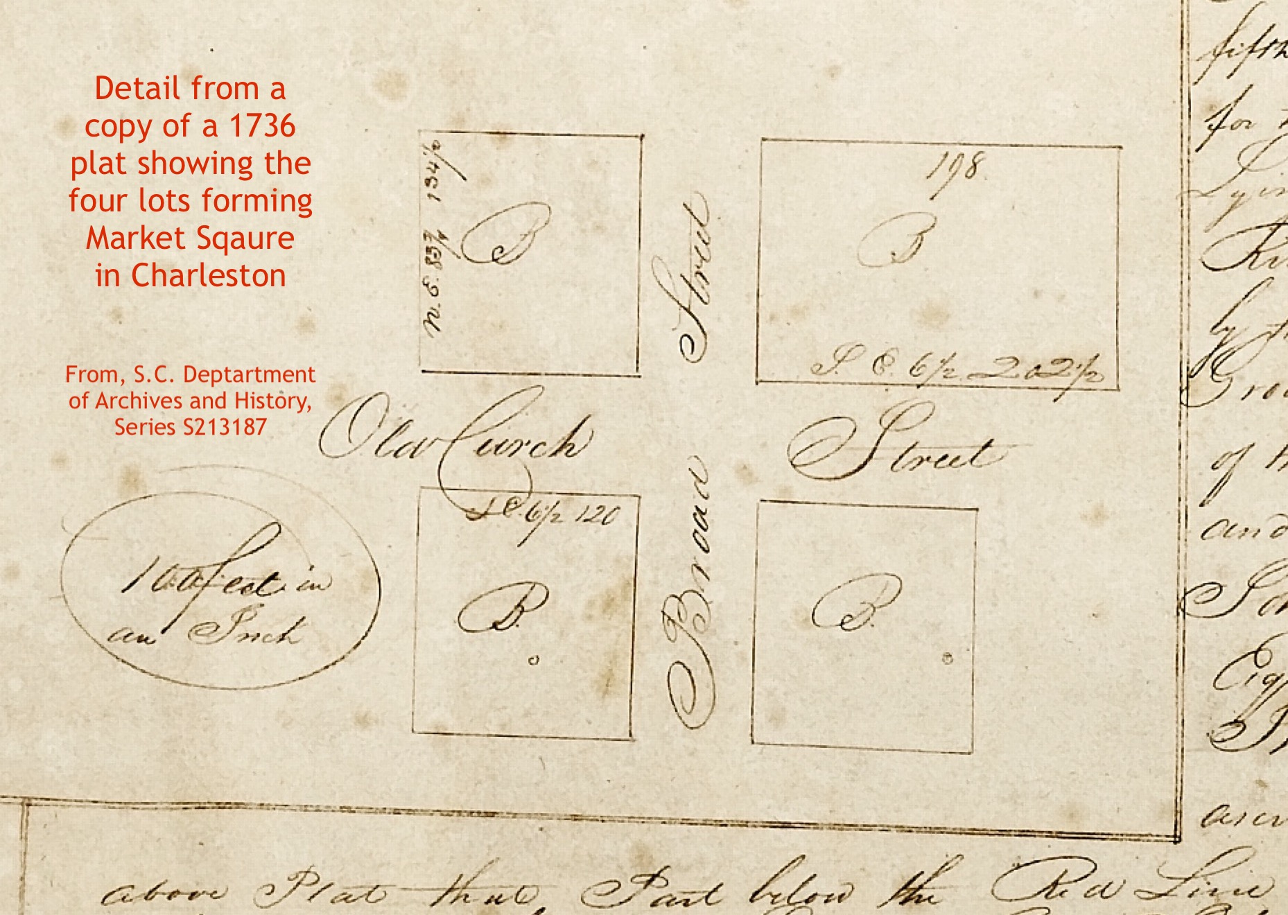
At the intersection of the town’s two principal streets, Culpeper inserted a traditional feature common to all “market towns” in England—a market square. This broad area encompassing two-and-a-half acres was reserved for public use, though not exclusively for market purposes. The proper names “Market Place” and “Market Square” coexist in surviving colonial descriptions of this site, but both names faded from local memory by the turn of the nineteenth century as Charleston became less British and more American. The erection of four public buildings on the four corners of Market Square prompted twentieth-century observers to describe the intersection of Broad and Meeting Streets as the “Four Corners of the Law.” That touristy name remains in circulation today because few recall the original name Market Square and few recognize that the original square survives on the landscape of twenty-first century Charleston. We’ll talk more about Market Square in a future program.
Culpeper then subdivided the remaining acreage by creating a grid of additional streets that were both perpendicular and subordinate to the principal pair. The directions sent by the Lords Proprietors differentiated between primary, secondary, and tertiary streets. Accordingly, Culpeper’s model of the town included a secondary tier of smaller streets to the south, east, north, and west of the Market Square, which subdivided the remaining landscape into squares or blocks of similar (though not entirely regular) proportions. We recognize these streets today as Tradd, Church, Queen, and King Streets. Shorter tertiary streets, farther removed from the Market Square, include portions of those currently known as Archdale, Legare, Lamboll, and Pinckney.
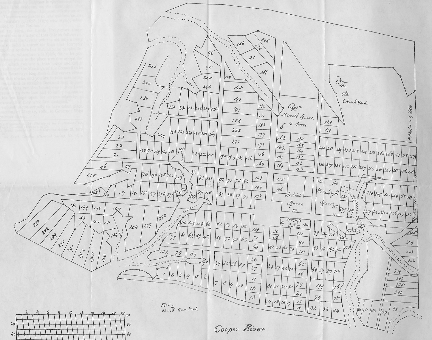
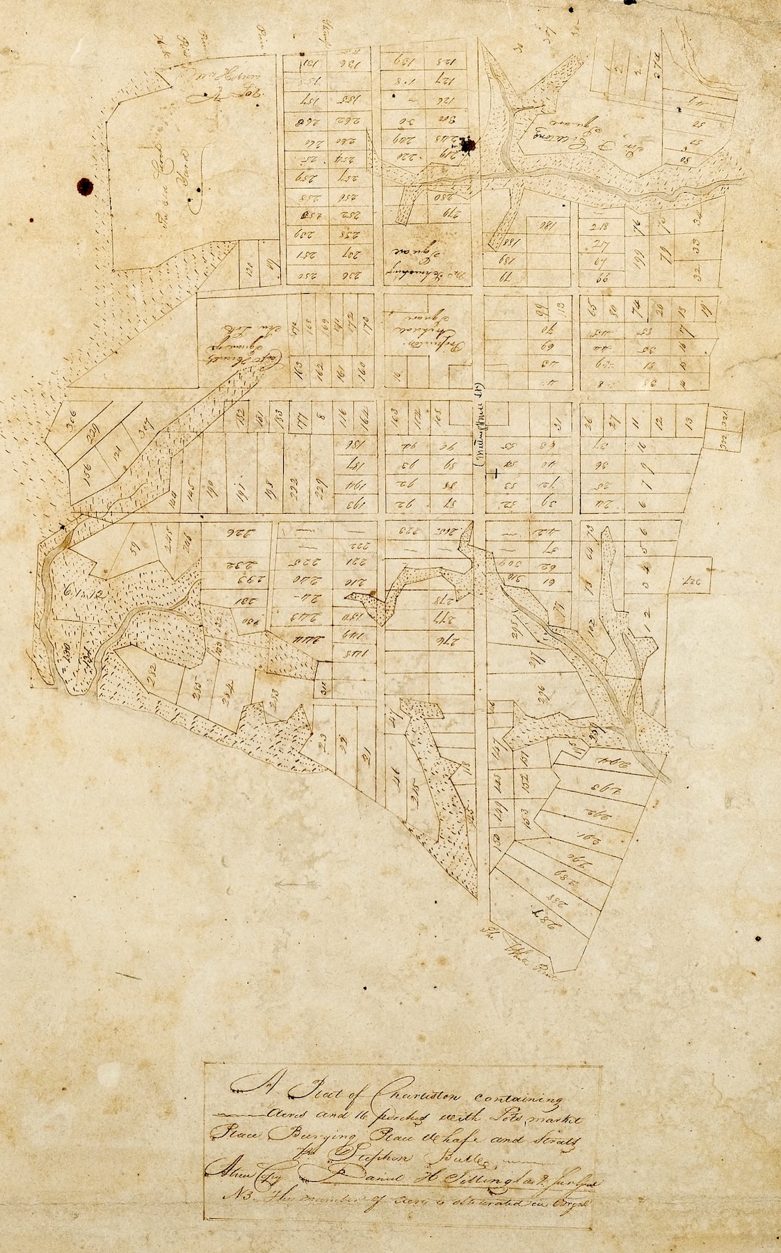
Culpeper then subdivided the blocks into hundreds of smaller building lots, most of which contained roughly one half of an acre. Owing to the varying size and shape of the blocks, the proportions of the resulting half-acre lots vary greatly. Some were nearly square, others long and thin. A few were trapezoidal, others nearly triangular, and a few were simply irregular blobs of leftover land. In short, there was no uniformity of lot shape in Culpeper’s plan. Extant copies of the Grand Model and the associated records of grants and property conveyances demonstrate that the original town plan included approximately 350 lots, a handful of which contained several acres. The precise number of lots is ambiguous, however, because of ancient defects in the numbering of the lots and various numbering mistakes recorded in ancient legal conveyances.[13]
John Culpeper probably completed his town plan on a sheet of paper or parchment at some point in the autumn of 1672. His grid of streets and lots filled all of the available high land between the southern tip of Oyster Point and the marked tree that defined the town’s northern boundary, but it did not leave room for a common. Culpeper’s omission of this traditional civic feature, deemed necessary by the Lords Proprietors, was probably due to the offer made by John Coming and Henry Hughes in February 1672 to cede half of their claimed land (estimated at 150 acres in July 1672), immediately north of the marked tree, for use as a common. We can surmise, therefore, that Culpeper’s plan reflected an assumption that the town’s common would exist to the north of the territory encompassed within his Grand Model.

If that hypothesis is accurate, then it seems likely that Culpeper completed his design for the town by the first week of September 1672. On the ninth day of that month, John Coming appeared before South Carolina’s Grand Council and rescinded his earlier offer to donate land for a town common. By offering to sacrifice part of his land the previous February, Coming and his associate, Henry Hughes, had intended to set an example to induce those who claimed land to the north to reciprocate by sacrificing a similar portion of their land, thereby allowing Coming and Hughes and their neighbors to simply shift all of their successive claims several hundred feet to the northward. That plan did not materialize, Coming informed the Council, because the various neighbors to the north had “altogether refused” to follow his example. Unwilling to sacrifice half of acreage he claimed while his neighbors protected their parcels, Coming (and by association, Hughes) withdrew the offer to donate 150 acres to create a common for the town.[14]
Although Culpeper’s model for the town at Oyster Point did not include the large common envisioned by the Lords Proprietors, we can discern a smaller substitute in the northwest corner of his plan. Between the western end of modern Queen Street and the town’s northern boundary (now Beaufain Street), the surveyor included a broad vacant area to the west of modern Logan Street. This site, containing approximately ten to fourteen acres, was apparently used for various public purposes during the town’s early years, but several private grants made in 1698 reduced it to a four-acre reservation then known as “the Old Church Yard.”[15]
The “original” draft of Culpeper’s scaled plan does not exist, and it was probably destroyed in the late seventeenth century as later surveyor generals revised and amended the initial design.[16] The South Carolina Department of Archives and History (SCDAH) in Columbia holds four copies of the Grand Model, including two parchment copies in poor condition that might date from the turn of the eighteenth century, and two paper copies created more than a century after Culpeper’s original plan. The South Carolina Historical Society holds a fifth copy, a parchment thought to date from 1725, a reproduction of which the Society published in 1908.[17]
Transferring the Model to the Ground:

The town plan drafted in 1672 was a scaled representation of the actual landscape in question. As such, it embodied a set of tacit instructions that the Surveyor General and/or his deputies had to translate and transfer onto the physical landscape. The tools required for such work in the late seventeenth century were simple but effective. They almost certainly used a circumferentor, a portable instrument featuring a compass mounted atop a wooden staff or tripod, which allowed the surveyor to measure angles between fixed points on the landscape. To calculate the distance between points, they used a surveyor’s chain measuring sixty-six feet divided into one hundred individual links.[18]
The chief obstacle to the surveyors who inscribed the town plan on the ground at Oyster Point was the landscape itself. A maritime forest covered the peninsula, including palmettos, live oaks, pines, and all manner of native brush and groundcover. The nascent English settlement could scarcely afford to divert the labor and resources necessary to clear a three-hundred acre town site, so the men tasked with laying out the streets and lots might have followed footpaths established by the former Etiwan inhabitants.[19]
The surveyors probably commenced their work along the Cooper River waterfront, driving a series of wooden stakes in the ground to establish the outline of the half-mile-long “wharf” that would become East Bay Street. The area reserved for this public landing likely measured sixty-six feet wide (the length of one surveyor’s chain) during the 1670s and 1680s, but the creation of a brick “wharf wall” along the east side of the wharf in the 1690s narrowed the space to less than sixty feet wide. That half-mile-long brick wall was demolished after the American Revolution, however, and East Bay Street finally attained a mostly-uniform width of sixty-six feet in 1787.[20]

Turning westward from the center of the Bay Street in the autumn of 1672, the surveyors staked the breadth and trajectory of the broad thoroughfare that became known as Broad Street, and the commodious perpendicular analog that became Meeting Street. Both of these streets also measured sixty-six feet in breadth, the convenient length of the measuring chain. The rest of the surveyors’ work probably followed the same sequence described earlier. Using John Culpeper’s scale model as a guide, they laid out the town’s secondary streets (Tradd, Queen, Church, and King Streets), which were all thirty-three feet (or half a chain) in width.[21]
Despite the obstructive presence of numerous trees and native brush, the task of outlining the town’s streets and blocks followed a rather straightforward procedure. Far more time and effort was required to subdivide the several blocks into approximately 350 lots, most of which contained one-half of an acre. The combined work of surveying, measuring, and driving stakes to outline the streets and lots probably consumed many weeks, if not months, and might have continued into the spring of 1673. It might have been completed before July 1673, when South Carolina’s Grand Council noted that “John Culpeper Surveyor Generall hath run away from this settlem[en]t.”[22] Mr. Culpeper left Charleston for reasons unknown and settled in North Carolina, where he led an uprising in 1677 now known as “Culpeper’s Rebellion.”
Amendments to the Grand Model:
Extant records demonstrate that at least a few settlers were residing at Oyster Point during the mid-1670s, but the earliest surviving records of the provincial government assigning specific town lots to individuals date from the spring of 1678. The reasons behind this five-year gap are now something of a mystery. The settlers and their leaders might have been preoccupied with other, more pressing activities during that time, or perhaps Mr. Culpeper left the colony before finishing the work of laying out the town’s streets and lots. Whatever the reason, the paper trail of settlement at Oyster Point commenced in earnest in 1678. In the spring of 1680, the unnamed town fulfilled the hopes of the Lords Proprietors by becoming “New Charles Town,” the official capital and principal port of South Carolina.[23]
As the town expanded in the latter years of the seventeenth century, subsequent surveyors added text to their copies of the Grand Model to identify new features. The surviving copies include labels for “Colleton Square” (granted in early 1681), “Archdale Square,” (1683), “Schenkingh’s Square” (1688), “Mr. Hobson’s 4 Lotts” (1689/90), and “Capt. Hawett’s Square of 10 Lotts” (1694). During these same years, various property owners began creating new streets and alleys by mutual consent to facilitate movement through the town. Elliott Street, for example, was created in the spring of 1683 by combining a slice of ten feet from lot numbers 10 and 37, with a slice of ten feet from lot numbers 11, 12, 13, 26, and 27.[24] Similarly, Unity Alley was created in the mid-1690s by taking a few feet from the northern edge of lot number 17 and from the southern edge of lot number 19.[25] Later generations in the eighteenth and nineteenth centuries created many more convenient passageways not included in John Culpeper’s original design.
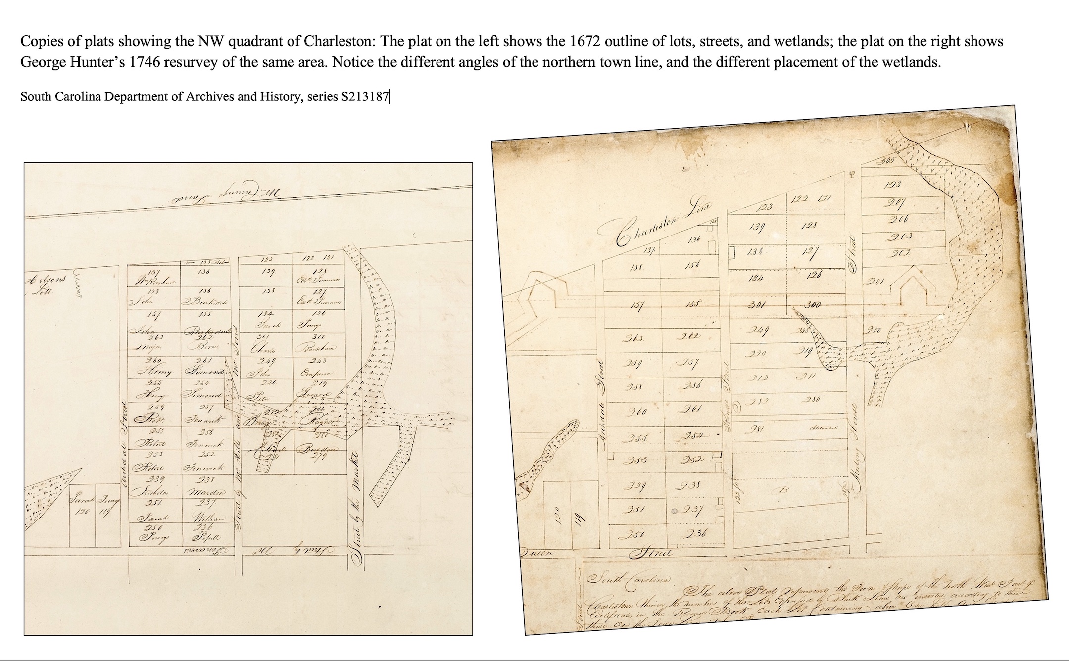
The most significant alteration of the Grand Model occurred during the second quarter of the eighteenth century, however. A resurvey of urban Charleston, ordered by the provincial legislature in 1722, identified significant questions about the faulty placement of several streets and numerous lot boundaries within the outline of the Grand Model. Surveying errors made within the forested environment of Oyster Point in the early 1670s had distorted the trajectory of various lines. Most of the errors affected the shape and size of lots in the northern third of the town plan, from Queen Street to the northern boundary, but the south end of Meeting Street was also skewed to the west. While Culpeper’s scaled model of the town plan had embraced slightly less than 300 acres of land, the area staked out on the ground covered slightly more than 300 acres.[26]
Because the town’s earliest settlers clustered within the east-central part of the town, between the south sides of Tradd and Queen Streets, they apparently overlooked the surveying mistakes of the 1670s for several decades. The construction of defensive fortifications in 1704 around sixty-two acres of the east-central part of the town masked the errors for a further generation.[27] Political dysfunction during the late 1720s stifled debate of these issues until 1733, when the South Carolina General Assembly slowly began to address the defects in the lots and streets in the northern part of the town plan that had existed for sixty years. A significant example of that work was the adoption of a revised path and a revised name for Dock Street, which officially became Queen Street in April 1734.[28] After several years of rectification work, Surveyor General George Hunter created a revised map in 1746 that finally settled the lot boundaries in the northwestern quadrant of the town plan.[29] His work, which reshaped “Dutch Town” and the area now known as “The French Quarter,” deserves a program of its own.
The Legacy of the Grand Model:
The early inhabitants of “New Charles Town,” as it became known in 1680, began subdividing their half-acre lots almost immediately, a practice that led to the profusion of smaller parcels that we see in the city today. As the subdivided lots changed hands during the late seventeenth and eighteenth centuries, however, the property owners of Charleston continued to refer to the original lot numbers in the paper records of their real estate transactions. That tradition began to wane in the 1780s, during the American Revolution. After capturing Charleston in May 1780, agents of the British Army assigned address numbers to all the buildings south of Boundary Street (now Calhoun Street). The numbering system deployed in 1780 evolved greatly over the ensuing years, but street address numbers quickly replaced Grand Model lot numbers in the records of real estate conveyances during the latter years of the eighteenth century. Memory of the Grand Model faded in Charleston as the city’s footprint expanded to the north and west, filling tracts of land and marsh that John Culpeper had excluded from his original design.[30]
Despite these changes, the town plan created for Oyster Point in 1672 remains embedded within the landscape of twenty-first-century Charleston, complete with corrections made in the 1730s and 1740s to settle ancient surveying errors. The Grand Model of Charles Town is an important but often overlooked asset in the city’s arsenal of history. The slightly-irregular plan represented a compromise between the lofty aspirations of the Lords Proprietors and the practical reality of the available terrain. John Culpeper’s scaled plan was imperfectly executed on the ground, and a succession of later inhabitants modified the plan to suit their needs. Its streets were considered commodious three and a half centuries ago, but now seem narrow and quaint. Civic leaders planning other towns in South Carolina—past and present—have long looked to Charleston for ideas about how (and how not) to organize a community. Despite the city’s founding flaws, throngs of visitors flock to the Palmetto City every year. Why? Because a ramble down one of Charleston’s storied streets is an exercise in time travel.
[1] Early generations of Charlestonians identified the plan by a variety of names. The earliest surviving grants of lots at Oyster Point, dating from the late 1670s and 1680s, describe it as the “Grand Modell of the said town.” An act ratified by the South Carolina General Assembly in July 1707 identified it as the “grand plott” of Charles Town. It was called the “town plot” in legislative acts ratified in April 1708 and March 1719. The abortive act to incorporate Charles City in June 1722 mentioned the “Grand Modell or plot of the said town.” Property conveyances recorded during the second and third quarters of the eighteenth century frequently described it the “plan or model” of the town. In 1908, Charleston judge and historian Henry A. M. Smith published the first piece of historical scholarship related to the original town plan of modern Charleston. Smith’s article resurrected the long-forgotten phrase “Grand Model,” which subsequent writers adopted and have employed ever since.
[2] Joseph Dalton’s letter to Lord Ashley, dated 20 January 1671/2 provides the earliest known evidence of Sayle’s reservation. See Langdon Cheves, ed., “The Shaftesbury Papers and Other Records Relating to Carolina and the First Settlement on Ashley River Prior to the Year 1676,” in Collections of the South Carolina Historical Society, volume 5 (Charleston: South Carolina Historical Society, 1897), 376–83.
[3] For more information about the broader philosophical “Grand Model” of Carolina, see Thomas D. Wilson, The Ashley Cooper Plan: The Founding of Carolina and the Origins of Southern Political Culture (Chapel Hill: University of North Carolina Press, 2016). Note, however, that Wilson’s philosophical discussion of the town plan at Oyster Point, pages 110–18, does not address the practical realities of the plan’s execution on the ground.
[4] Instructions from the Lords Proprietors to the governor and council of Carolina, 1 May 1671, in William James Rivers, A Sketch of the History of South Carolina to the Close of the Proprietary Government by the Revolution of 1719 (Charleston, S.C.: McCarter & Co., 1856), 366–69. In this and all other quotations in this essay, I have preserved the spelling found in the original source.
[5] Lord Ashley to Sir John Yeamans, 18 September 1671, in Cheves, Shaftesbury Papers, 342–43.
[6] “Agrarian Laws or Instructions from the Lords Proprietors to the governor and Council of Carolina,” 21 June 1672, in William James Rivers, A Sketch of the History of South Carolina to the Close of the Proprietary Government by the Revolution of 1719 (Charleston, S.C.: McCarter & Co., 1856), 356–59, citing BPRO, North Carolina, Board of Trade, volume 2, p. 83.
[7] Joseph Dalton to Lord Ashley, 20 January 1671/2, in Cheves, “Shaftesbury Papers,” 379.
[8] A. S. Salley Jr., ed., Journal of the Grand Council of South Carolina, August 25, 1671–June 24, 1680 (Columbia: The State Company, for the Historical Commission of South Carolina, 1907), 29.
[9] A. S. Salley Jr., ed., Warrants for Lands in South Carolina, 1672–1679 (Columbia, S.C.: The State Co., for the Historical Commission of South Carolina, 1910), 22; Henry A. M. Smith, “Charleston and Charleston Neck: The Original Grantees and the Settlement along the Ashley and Cooper Rivers,” South Carolina Historical and Genealogical Magazine 19 (January 1918): 1–10.
[10] For references to the creation of Beaufain Street, see South Carolina Department of Archives and History, Journal of the South Carolina Commons House of Assembly, No. 38, part 1, pages 126–27 (8 August 1769) and 144–45 (14 August 1769); Act No. 991, “An Act for laying out and establishing several new Streets in the North-west parts of Charlestown; and for building a new Parsonage House for the Parish of Saint Philip, Charlestown; and for empowering the Vestry and Church-Wardens of the said Parish, for the time being, to lay out part of the Glebe Land of the said Parish, in Lots, and to let the same out on Building leases; and for other purposes therein mentioned,” ratified on 7 April 1770, in David J. McCord, ed., The Statutes at Large of South Carolina, volume 7 (Columbia, S.C.: A. S. Johnston, 1840), 93–96.
[11] An undated survey, ca. 1732–1740, in the Surveyors’ Notebook for Charles Town, 1732–1752, Series S213185 at SCDAH, page 78 (folio 41, verso) indicates that the “town line” extended 21.6 chains (1,425.6 feet) westward of a stone on the west side of the Broad Path (i.e., King Street). That measurement is commensurate with the present distance between King and Wilsons Streets.
[12] See Episode No. 180, “The Genesis of East Bay Street: Charleston’s First Wharf, 1680–1696.”
[13] For an overview of the lots of early Charleston, see Susan Baldwin Bates and Harriott Cheves Leland, Proprietary Records of South Carolina, Volume Three: Abstracts of the Records of the Surveyor General of the Province, Charles Towne 1678–1698 (Charleston, S.C.: History Press, 2007).
[14] Salley, Journal of the Grand Council, 1671–1680, 45–46 (9 September 1672).
[15] See Episode No. 200, “The Forgotten Dead: Charleston’s Public Cemeteries, 1672–1794.” A certificate of admeasurement dated 22 March 1689/90, concerning four lots for Joshua Hobson at the modern southwest corner of Archdale and Beaufain Streets, refers to an adjacent “parcel of ground reserved for a common bur[y]ing place”; see Bates and Leland, Proprietary Records of South Carolina, Volume Three, 63. This reference provides the earliest-known mention of the site described in later copies of the Grand Model as “The Old Church Yard.”
[16] The text of Act No. 464, “An Act for the Good Government of Charles Town,” ratified on 23 June 1722, ordered a resurvey of the town, after which the surveyors were to create a new plat and destroy earlier copies of the “Grand Modell or plot of the said town”; see Bruce T. McCully, ed., “The Charleston Government Act of 1722: A Neglected Document,” South Carolina Historical Magazine 83 (October 1982): 303–19. The report of a legislative committee in 1733 complained that the several extant copies of the Grand Model were defective; see SCDAH, Journal of the South Carolina Commons House of Assembly, 1731–1733 (Sainsbury’s transcription), page 1118 (6 September 1733).
[17] The four extant copies at SCDAH are described in Bates and Leland, Proprietary Records of South Carolina, Volume Three, 33–36. The copy held by the South Carolina Historical Society is identified as manuscript item 32-07-05, and an accompanying list of lots and names is 32-07-06.
[18] For more information on surveying techniques and equipment in early South Carolina, see Linda M. Pett-Conklin, “Cadastral Surveying in Colonial South Carolina: A Historical Geography,” Ph.D. diss., Louisiana State University and Agricultural and Mechanical College, 1986.
[19] Jean Boyd’s 1686 letter from Charleston mentions “woods full of houses”; see Harriott Cheves Leland and Dianne W. Ressinger, “‘Ce Païs Tant Désiré’: ‘This Much Longed-For Country,’” Transactions of the Huguenot Society of South Carolina, 110 (2006): 26. A committee report made in 1733 stated that the peninsular town site “full of woods” at the time of the “original survey.” SCDAH, Journal of the South Carolina Commons House of Assembly, 1731–1733 (Sainsbury’s transcription), page 1117–18 (6 September 1733).
[20] See Episode No. 180, “The Genesis of East Bay Street: Charleston’s First Wharf, 1680–1696”; Episode No. 74, “Demilitarizing Urban Charleston, 1783–1789”; Act No. 1366, “An Act for repealing such Acts of Assembly as regulate and restrict the erection of houses below the Curtain Line on the Bay of Charleston; to widen Bay-street, and to permit houses of any size to be erected to the eastward of the same,” ratified on 27 March 1787, SCDAH, Records of the South Carolina General Assembly, engrossed copies of acts.
[21] For examples of various street widths, see the Surveyors’ Notebook for Charleston, SCDAH. In his 1680 letter, Maurice Mathews stated that the two principal streets in the town plan measured sixty feet wide, as did the reserved wharf or quay along the Cooper River waterfront.
[22] Salley, Journal of the Grand Council, 1671–1680, 61 (12 July 1673).
[23] The phrase “New Charles Town” appears in numerous documents created in the 1680s; see the various abstracts in Bates and Leland, Proprietary Records, Volume Three.
[24] Articles of agreement between sundry lot owners in Charles Town, 26 March 1683, in SCDAH, Records of the Register of the Province, Book No. 2 (1675–1696), pages 442–44. This transaction is abstracted in Susan Baldwin Bates and Harriott Cheves Leland, Proprietary Records of South Carolina, Volume Two: Abstracts of the Records of the Register of the Province, 1675–1696 (Charleston, S.C.: History Press, 2006), 164.
[25] The alley created from lots 17 and 19 by Richard Codner and Jonathan Amory was mentioned in a conveyance from William Danforth to John Lynch, dated 23 October 1711 and recorded in SCDAH, Records of the Register of the Province, Book H (1711–14), 173–74. Richard Codner Sr. acquired all or part of Lot No. 17 by 1689, but was dead by 1698. Because Jonathan Amory also died in 1698, the alley must have been created sometime between 1689 and 1698.
[26] These estimates based on recent efforts to draw a Grand-Model-shaped polygon over a modern map of the same geography, using the GIS measuring tools provided on the City of Charleston website.
[27] See Episode No. 230, “Creating a Walled City: The Charleston Enceinte of 1704.”
[28] Act No. 579, “An Act for the better and more certain regulating and adjusting the metes and boundaries of Queen-street, formerly called Dock-street, in Charlestown, and for appropriating such waste and vacant lands as shall be found on the North side of the said street,” ratified on 9 April 1734, in David J. McCord, ed., The Statutes at Large of South Carolina, volume 7 (Columbia, S.C.: A. S. Johnston, 1840), 74–75.
[29] George Hunter’s original plats of resurvey do not survive, but Surveyor General Daniel H. Tillinghast made precise copies of them circa 1820. See Tillinghast’s copy of George Hunter’s survey of the northwest quadrant of Charleston, dated 3 June 1746, in SCDAH, Copies of Plats and Plans (series S213187), volume 1 page 5.
[30] For an overview of the city’s street numbering system, see my essay on “The Street Numbers of Peninsular Charleston.” For an overview of the city’s northward expansion, see Episode No. 80, “Grasping the Neck: The Origins of Charleston’s Northern Neighbor,” and Episode No. 81, “Squeezing Charleston Neck, from 1783 to the Present.”
NEXT: Park Circle: Vestige of the Original North Charleston Concept
PREVIOUSLY: Planning Charleston in 1672: The Etiwan Removal
See more from Charleston Time Machine