
At the beginning of the eighteenth century, South Carolina’s colonial government raised a fortified trace of earthen walls and moats around the nucleus of urban Charleston. These defensive works constrained the town’s growth for more than twenty years, but then quietly vanished before a burst of civic expansion in the mid-1730s. Questions of when and why the earthworks were dismantled have baffled generations of historians and inspired competing theories. In today’s program, we’ll unpack the forgotten story of government neglect that gradually reduced the “Walled City” during the late 1720s.
Over the past several years, I’ve crafted a number of podcast essays about Charleston’s early fortifications. My goal has been to explain not only the chronology of the urban fortifications, but also the broader historical context that defined their rise and fall. The principal source for this information is the extant manuscript journals of South Carolina’s provincial government, augmented by related government documents, which I’ve examined in numerous visits to the South Carolina Department of Archives and History in Columbia over the last two decades. As I described in Episode No. 230, for example, records created during the early years of the eighteenth century provide a relatively clear picture of when and why civic leaders decided to enclose the colonial capital within a network of walls surrounded by a moat: Fear of an imminent Spanish attack in late 1703 inspired the provincial government to appropriate funds for the rapid construction of the Charleston enceinte—a fortified enclosure—which was effectively completed by the end of 1704.
Similarly, government records created over the ensuing three decades contain numerous references to the repair and maintenance of the brick curtain wall along the east side of East Bay Street and the earthen walls enclosing the south, north, and west sides of Charleston. The extant documents might not contain as many details as we’d like to see, but they represent a nearly-continuous paper trail for tracing the evolution of the town’s early fortifications.[1]
Some years ago, while reading through South Carolina’s legislative journals of the 1720s and early 1730s for the first time, I expected to find the text of a discussion regarding the fate of Charleston’s earthen walls. The provincial government used tax revenue to build and maintain the enceinte surrounding the capital, so I imagined that its removal would require some act of government, like a resolution, ordinance, or statute. I found no such discussion, however, nor any sort of act or decree that might have triggered the demolition of the public earthworks. By the time I reached the legislative journals of the mid-1730s, I found discussions of extending Church Street, Dock Street, Bay Street, Tradd Street, and Broad Street beyond the boundaries of the fortifications created thirty years earlier. The earthen walls were evidently gone by 1733, but I found no explanation of how or when they disappeared.
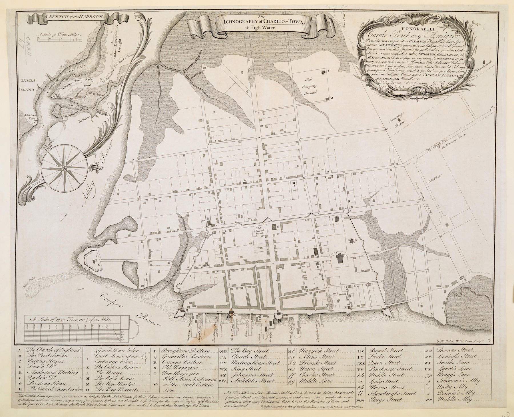
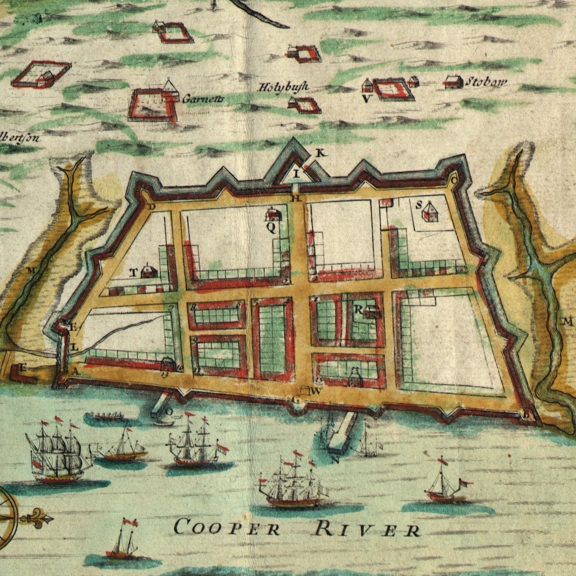
Turning to secondary sources for help, I discovered that no historical text published in the past three centuries offered a reliable answer to the puzzle of Charleston’s disappearing fortifications. In fact, some observers living in the eighteenth century published inaccurate solutions to the question. For example, the well-known map printed in London in 1739, titled “The Ichnography of Charles-Town at High Water,” depicts the outline of the fortified walls that formerly constrained the south, north, and west sides of the town. A caption printed in the lower left corner of the map states that “the double lines represent the enceinte as fortified by the inhabitants for their defence against the French[,] Spaniards & Indians[;] without it were only a few houses & these not thought safe till after the signal defeat of ye Indians in the year 1717, at which time the north west & south sides were dismantled & demolished to enlarge the town.” That text is definitely inaccurate, however, because extant legislative records demonstrate South Carolina’s provincial government maintained the earthen fortifications of Charleston for several years beyond 1717.
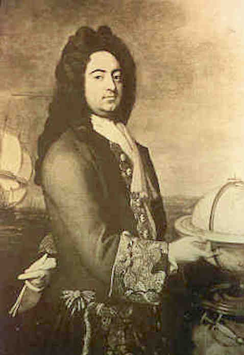
Another brief statement about the removal of Charleston’s earthen fortifications appears within an essay about defending South Carolina, published in the Gentleman’s Magazine of London in 1745: “In Queen Anne’s war [1702–13], this place was strengthened by tolerable works on the land side, which were razed by General Nicholson, when governor, to oblige some of his particular friends.”[2] Francis Nicholson (1655–1728) was appointed governor of South Carolina the autumn of 1720 and held that title until his death in March 1728, but he actually resided in Charleston between May 1721 and May 1725. The essay published twenty years later implies that Nicholson was somehow responsible for demolishing the earthworks in the mid-1720s, either by executive decree or by steering the provincial legislature towards that end. The extant government papers from that period do not support this theory, however, although Governor Nicholson was certainly involved in the process.
Over the past decade, I’ve re-read the extant legislative journals of the 1720s multiple times and combed archives in London searching for obscure records that might illuminate this history mystery. The answer, it turns out, was embedded in the legislative journals of the mid-1720s that I initially consulted. It did not leap off the page, but it came into focus after I revisited the clues and considered the broader context. Charleston’s first earthen walls faded out of existence over a period of several years, and the facts related to their disappearance form a rather complex narrative. For the first time in three hundred years, the real story can now be told.
As I mentioned earlier, the Charleston enceinte was effectively completed by the end of 1704. Nine years later, in September 1713, a powerful hurricane caused extensive damage to the town’s urban defenses. No repairs were made before another hurricane swept across Charleston in September 1714 and further weakened the fortifications. South Carolina’s provincial government appropriated money to repair the town’s defenses at the end of 1714, but a succession of misfortunes retarded that work in the ensuing years.[3] The outbreak of the Yemasee War in April 1715, for example, threatened the survival of the South Carolina colony. While the General Assembly appropriated money for soldiers and weapons to quell the Native American revolt, hundreds of settlers living across the Lowcountry fled to Charleston for protection. The provincial government made modest repairs to the urban fortifications during the two-year war to render the capital a safe haven against Indian attack.
The Yemassee war disrupted the agriculture and trade of South Carolina and wrecked the local economy. Charleston’s defensive works were apparently in a low state of repair when Blackbeard and other pirates harassed the capital in 1718 (see Episode No. 91), at which time the legislature scarcely had sufficient resources to defend the port. The situation deteriorated further when Carolinians learned that Britain had declared war against Spain in the late summer of 1718 (the War of the Quadruple Alliance, 1718–20). Rumors of Spanish forces assembling at Havana to launch an attack on Charleston in the autumn of 1719 panicked South Carolinians who felt that the Lords Proprietors were not contributing sufficient funds to defend the colony. Their frustration led a coup d’état that December, known as the Revolution of 1719, that deposed Governor Robert Johnson.
In a letter to the British Board of Trade written a few weeks after the coup, the rebel leaders who had usurped the government of South Carolina sent a brief description of the capital fortifications: “Charles Town is the only town and port in the province[,] whose fortifications being much damaged by storms, and the great guns dismounted, and every thing relating to the preservation of the government wholly abandoned to negligence and confusion, and the inhabitants finding themselves disappointed (by the ministry of the Proprietors) of the several methods they had taken to restore those fortifications, were quite heartless and were ready sooner to quit the province than be at any more expence about the defence of it, had they not been elevated and spirited by the late efforts made to have the government in his Majesties hands. Upon which they with heart and hand are repairing the fortifications upon the same, and all without the contribution of one penny by the Proprietors.”[4]
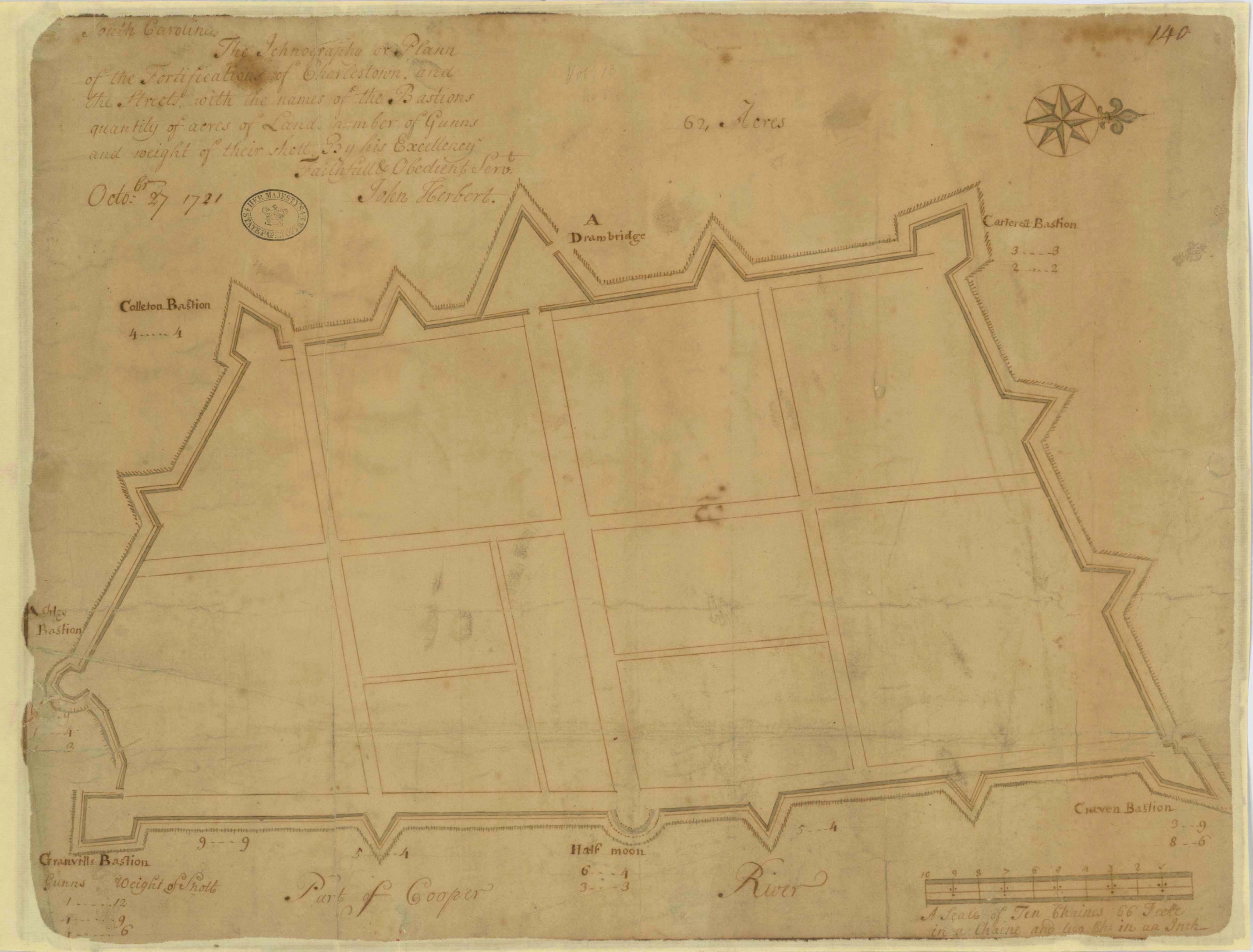
Francis Nicholson, appointed provisional royal governor of South Carolina by King George I, arrived in Charleston in late May 1721 during a time of peace between Britain, Spain, and France. An experienced military officer, Nicholson took a keen interest in the provincial defenses, especially those within the capital. He evidently commissioned a local officer, Colonel John Herbert, to draft a plan of the fortifications surrounding urban Charleston, which Nicholson then sent to the Board of Trade in London. Herbert’s pen-and-ink drawing, dated 27 October 1721 and titled “The Ichnography or Plann of the Fortifications of Charlestown,” depicts a robust enceinte with numerous cannon posted in the several bastions and redans around the town. Herbert’s plan appears to show a single drawbridge within the ravelin or fortified gateway at the intersection of Broad and Meeting Streets, although the initial construction of that feature in 1704 included two draw bridges. Herbert’s illustration of the ravelin was evidently incomplete. Five months after he completed the drawing, in March 1721/2 (on the old Julian Calendar), the South Carolina legislature resolved to fund repairs of the “two draw bridges across the Broad Street.” In short, the fortified enceinte created in 1704 was still largely intact in the spring of 1722.[5]
At the conclusion of a legislative session in June 1722, the South Carolina General Assembly ratified an act to incorporate the capital town and rebrand it “Charles City and Port.” The act of incorporation was a pet project initiated by Governor Nicholson, but it was immediately unpopular with the majority of local inhabitants. The city’s odd municipal structure included hereditary offices and several features of questionable legality, all of which induced a number of citizens to lobby contacts in England to cancel the act of incorporation. In the meantime, the new government of Charles City and Port held jurisdiction over “all lotts, streets, lanes, highways, alleys, docks, wharfs, keys [i.e., quays], landings, and all the edifices, buildings, market places, and buriall places in Charles Town together . . . as they are laid out and distinguished in the Grand Modell or plot of the said town.”[6] Coincidentally, on the same day Governor Nicholson signed the act of incorporation, the Commons House of Assembly recorded a payment for repairs made to “the draw bridge” (singular).[7] This notation in June 1722 is the last reference to the draw bridge(s) that once stood within the fortified ravelin at the intersection of Meeting and Broad Streets.
The gradual erasure of the drawbridges and earthen fortifications commenced with a powerful hurricane that swept across the Lowcountry in mid-September 1722. Having witnessed the “violent winds and rain” in Charles City and Port, Governor Nicholson and his advisory Council observed that “great damage has been done to the fortifications and front wall thereof, and several pieces of timber, plank and iron spikes &ca. has fallen down from the same.” After the storm, the executive cabinet ordered “that an advertisement be immediately published strictly forbidding all persons whatsoever in his Matys. name from taking, carrying away or destroying any of the said timber, plank, iron work or other materials belonging to the sd. fortifications and front wall upon pain of being prosecuted with the utmost severity of the law. And that all officers and other persons whatsoever be thereby further ordered and required to use their utmost diligence in preserving and securing the aforesaid timber and other materials for the use and service of His Majesty and this his province.”[8]
When the provincial legislature convened in early November 1722, Governor Nicholson summarized the state of the urban fortifications in the following words: “The late rains and winds have done us some damage in the fortifications of this city fronting the river. (According to my duty I endeavoured to secure the guns &c.) Also there is some damage to those on the land side, and to prevent the stockades &c. from being stolen, I had the loose ones secured, and this has been done without any public charge, and I must do the inhabitants of this City and Port justice that they by themselves or slaves readily and cheerfully did the work. I think every body ought to own [i.e., acknowledge], that the fortifying [of] this place was a great work in all respects, but time (the devourer of all things) hath much damnifed the same, and what shall be done in these affairs I leave it wholly to the Assembly.”[9]
The Commons House of Assembly then appointed a committee to consider ways and means of repairing the capital’s defenses. Their report, submitted in late November 1722, noted that “the fortifications at Charles City” and at Fort Johnson on James Island were “out of repairs,” and “will require a very large sum to put them in a good posture.” Considering the lingering debts incurred during the Yemasee War, the necessity of funding several frontier forts against French, Spanish, and Indian incursions, and “the great losses the inhabitants have suffered by the violence of the late winds and rain,” the committee opined that it would be impossible to raise the necessary funds to repair the fortifications by means of a general tax levied on the inhabitants. The Commons House therefore resolved to fund the repairs by printing more paper money, a form of government credit that had commenced in South Carolina in 1703. Governor Nicholson rejected the proposal to print additional bills of credit, however, because the British government had specifically instructed him to reduce the volume of paper currency circulating within the colony.[10] While elected representatives argued with the governor about funding methods during the winter of 1722/3, the damaged fortifications moldered.
In mid-February 1722/3, Governor Nicholson reminded the members of the Commons House to consider some appropriation for repairing the fortifications of the capital, “for unless there be something done about them I expect they will be quite ruined, & never a stockade left.” The House replied that a committee appointed to investigate the matter had recommended an appropriation of £2000 “for repairing the front fortifications of Charles City and removing the posts on the back of the city to be placed on the front and for providing ballast” stones to protect the waterfront brick fortifications from erosion. This simple proposal, though devoid of technical detail and political gravity, represents a major turning point in the story of the “Walled City.” Because the governor blocked the plan to print paper money to repair all of the fortifications in urban Charleston, the elected representatives resolved to appropriate a relatively small sum of tax revenue to repair only the brick curtain wall and bastions fronting the Cooper River waterfront. To minimize expenses, the government proposed to remove an unknown number of wooden posts from the earthworks surrounding the “back of the city” and plant them in the mud before the curtain wall as a sacrificial revetment to be backfilled with ballast stones taken from British merchant ships.
With the consent of Governor Nicholson and his advisory Council, the Commons House adopted the plan to transfer wooden posts from the back walls of Charles City to the front wall along the Cooper River waterfront. The House also advised Nicholson that the £2000 in question “ought to be paid into the chamber [i.e., treasury] of the said City,” because the municipal chamberlain or treasurer, Charles Hill, had “offered his services in paying that money [to various laborers] without expecting any thing for his trouble.” The governor and his advisory Council then assented to the plan, which also proposed that “the Mayor, Aldermen and Common Council [of Charles City] may have the disposal of the said money and be empowered to contract with proper persons for that service.”[11]
The plan to effectively abandon the capital’s earthen fortifications for the sake of economy apparently did not sit well with some members of the Commons House. One week after adopting that plan in February 1722/3, the House resolved to appropriate an additional sum of £8000, in newly-stamped paper bills of currency, “for building fortifications in Charles City.” In a message to Governor Nicholson, the Speaker of the House explained “that it is the policy of all wise governments to fortify themselves in time of peace, in order to their better defence in time of war, and the fortifications of this city not being sufficient to protect the same; we are come to a resolution to give £8000 over and above the £2000 already given to raise proper forts for the better defence thereof.” Nicholson and his advisory Council immediately rejected the new proposal, however, because it contradicted British orders to reduce the volume of paper currency in South Carolina. Funds to repair the fortifications, said the executive branch, would have to come from “a general tax upon the inhabitants of this Province.”[12]
Because the Commons House refused to levy additional taxes to fund the necessary repairs, the earthen walls were doomed. That fact must have been obvious to members of the legislature and the inhabitants of Charles City at that time. On 22 February 1722/3, the Commons House heard a report from a committee appointed “to view and examine the new plat of Charles City,” the fruit of a major re-survey of urban Charleston commissioned by the city’s act of incorporation eight months earlier. As elected leaders considered the future of the colonial capital, the committee recommended that “in case the back fortifications are demolished, that the proprietors of those lots who received satisfaction for the damage done to their lots by the said fortifications [i.e., in 1704], may have their lots again [after] paying back to the public, the money received by them.”[13] In short, the legislators of 1723 were already envisioning a city landscape devoid of fortifications.
The funds appropriated in February 1722/3 to repair the urban fortifications were delivered to the officers of Charles City and Port, who evidently spent the money as the provincial government had ordered. No record survives of precisely what they did, but their work initiated the process of demolishing the earthen fortifications of the “Walled City.”[14] The wooden “posts” removed from the fortifications along the south, north, and west sides of the city apparently formed a linear revetment; that is, a continuous or nearly-continuous row of upright or raked posts planted along the inside, outside, or both sides of the earthen walls to prevent the mounded earth from sloughing away. As such, the posts were an important structural feature of the earthworks, and their removal compromised the integrity of the walls. The militia officers superintending the urban artillery evidently recognized that the unsupported earthworks were no longer defensible. By the autumn of 1723, laborers had moved all the wooden posts from the “back” fortifications to the front curtain wall, and transferred all the cannon from the city’s west and north walls to the waterfront bastions.
On the 6th of October 1723, news arrived from London that the king’s lawyers had canceled and repealed South Carolina’s act to incorporate Charles City and Port. Charles City immediately reverted to unincorporated Charles Town, and the short-lived municipal government ceased to exist. The city chamberlain’s financial records, which likely contained details about important modifications to the fortifications, disappeared soon afterwards.[15]
In December 1723, the report of a committee appointed to inspect the fortifications stated that the “armory” within Granville Bastion housed “some old gates timber and old iron which came from the back part of the town” (i.e., the remnants of the old gate at the intersection of Broad and Meeting Streets, which evidently had been dismantled). The same report mentioned a “tumbling down” structure called “Ioors Fort”—likely synonymous with the earlier Ashley Bastion—which still housed a few cannons. In contrast, several “great guns” placed along the east side of East Bay Street at that time, slightly north of Granville Bastion, were identified as having been taken “out of the S.W. Bastion” (i.e., Colleton Bastion, near the intersection of Tradd and Meeting Streets). Similarly, Craven Bastion in December 1723 included several small cannons that had been removed “out of the N.W. Bastion” (i.e., Carteret Bastion, near the intersection of Meeting Street and Horlbeck Alley). These brief notations represent the last reference the western bastions of the Charleston enceinte.[16]
In February 1723/4, Governor Nicholson recommended to the Commons House, among other things, “that immediate and effectual care be taken concerning the fortifications of Charles Town and the ballast.” After considering how to preserve all of the town’s fortifications with as little expense as possible, the Commons House adopted an order or ordinance “that no person in this province at their utmost peril do presume to wheel cart or by any other means or ways carry away any earth or lands from any of the banks which were late the fortifications round Charles Town, or from any street or publick lott or place in the said town for any use or purpose whatsoever.” The governor and his advisory Council concurred with this order later the same day, and directed the Provost Marshal to promulgate the message throughout the town.[17] To underscore its importance, the General Assembly included this order in a law-enforcement statute ratified four days later. The penultimate clause of that law imposed a fine of £10 currency on “all and every person or persons that shall presume to take any dirt or land out of any street by cart, wheelbarrow, or by any other ways or means whatsoever.”[18]
Another powerful hurricane caused damage across the Lowcountry of South Carolina in early August 1724 and damaged the infrastructure of urban Charleston. According to a letter from Governor Nicholson to the Board of Trade, the storm “very much damaged the fortifications in this place,” and probably hastened the erosion of the unsupported earthworks.[19] Seven months later, in March 1724/5, the South Carolina Commons House debated the possibility of appropriating £50 out of the treasury “towards building a bridge over the marsh from the White point [to the south end of Church Street,] & also fifty pounds for building a bridge from Craven’s Bastion [at the north end of the Bay Street] to the lotts to the north part of the town.” The Upper House of Assembly dismissed the two proposed bridges, however, not because the south and north walls blocked the streets in question, but because “the streets cannot be continued without alterations of the lotts of several persons now absent from the province whose consent ought to be had thereto.”[20]
An inventory of the artillery mounted in urban Charleston in December 1725 described the waterfront defenses on the east side of the Bay Street in some detail but ignored the bastions and redans on the south, north, and west sides of the town.[21] A similar report made in January 1726/7 mentions a few cannons remaining at “Ioors Fort or Bastion,” which was described as being “quite out of repair,” but does not mention any of the other works standing on the “back” of the town. In fact, the 1726/7 report states that “the other part of the fortifications from Ioors [sic] Bastion round the back part of the town to Craven’s Bastion are allmost levelled & in no manner defencible.” The Commons House voted to spend money repairing the waterfront brick fortifications in early 1727, but provided no funds to preserve the disappearing earthen walls on the back of the town.[22]
South Carolina’s provincial government debated the need to repair Charleston’s fortifications during a brief quasi-war with Spain in 1727–29, but political dysfunction derailed their efforts and paralyzed the legislative process for several fruitless years. Meanwhile, powerful hurricanes in August 1728 and August 1730 caused further damage to Charleston’s waterfront curtain wall and no doubt contributed to the erosion of what remained of the town’s neglected earthen walls.[23] The British Crown’s purchase of the Carolina Colonies from the Lords Proprietors in 1729 placed South Carolina on a more stable footing as a royal property, and the return of Governor Robert Johnson in December 1730 initiated a more productive political environment in the spring of 1731. The local economy stabilized immediately, and the government collected significant revenue from taxes and other duties, but the General Assembly spent no new funds on defensive fortifications during a period of peace with France and Spain.
In April 1732, four months after the debut of Charleston’s first weekly newspaper, the Speaker of the Commons House, Robert Hume, published a two-part notice that represents a last known reference the town’s earthen entrenchments. The first part cited a clause from the statute of February 1723/4 that imposed a fine on persons “that shall presume to take away dirt or land out of any street by cart, wheelbarrow, or by any other ways or means whatsoever.” In the second part of his notice, Hume threatened to prosecute “sundry persons” who, “notwithstanding the said Act, have lately, and still do continue to dig up and carry away the dirt in the streets where the trenches formerly stood, to the great injury of the owners of the lotts fronting the same.”[24]
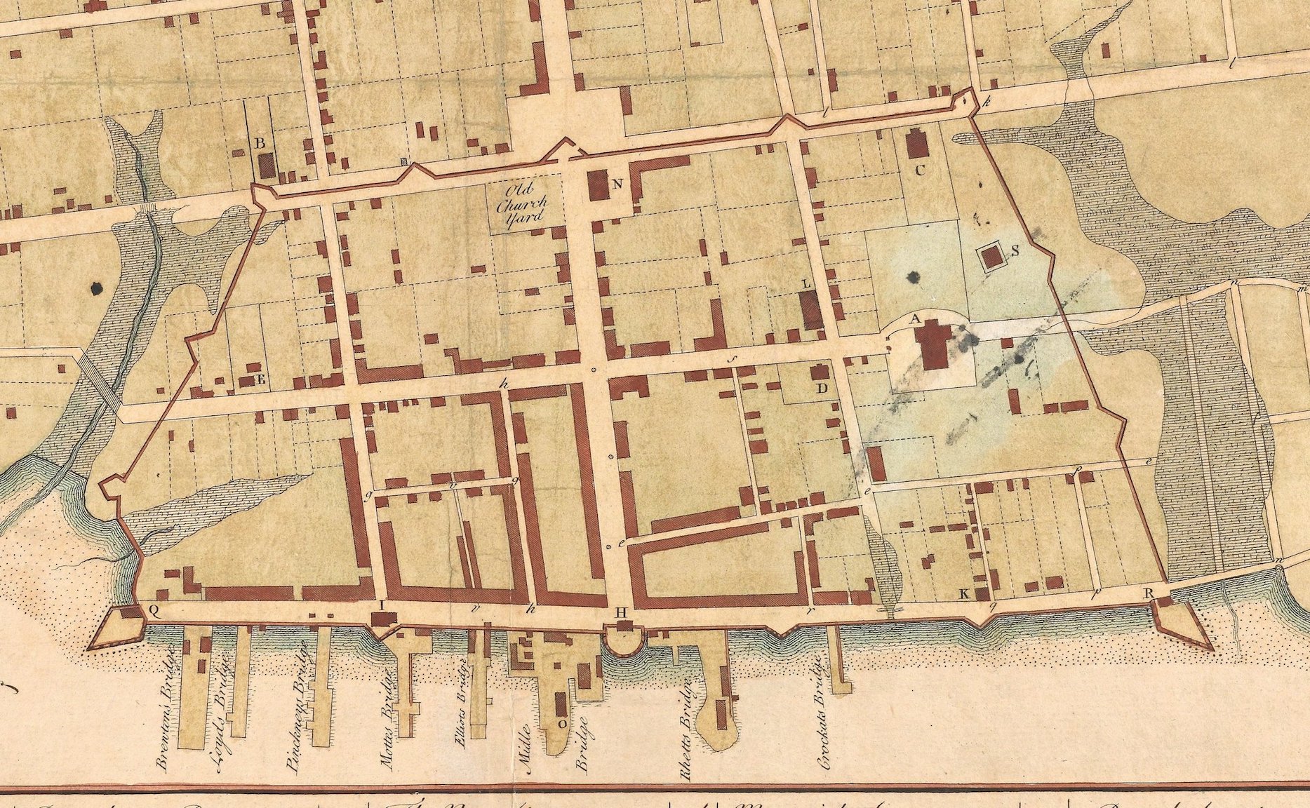
Robert Hume’s text confirms that some vestiges of the earthworks remained on the landscape of urban Charleston in the spring of 1732. More specifically, some unknown volume of the earthen remnants stood within one or more of the town’s public streets, either along the west side of Meeting Street, or perhaps at the south end of Church Street (near the Baptist Meeting House), or the north end of Church Street (just beyond St. Philip’s Church), or at the west end of Tradd Street (by the future site of First Scots Presbyterian Church), or at the west end of Dock Street, or at all of the above locations. Coincidentally, also in the spring of 1732, the Commons House appointed a committee to investigate the prospects of “regulating” or discovering the legal boundaries of Dock Street.[25] The earthen fortifications created in 1704 had long blocked the intersection of Dock and Meeting Streets, but in February 1732/3 the legislature read a draft of a bill for altering the path of Dock Street and extending it westward to the Ashley River. A detailed committee report on that subject submitted in September 1733 indicates that the junction of Dock and Meeting Streets was no longer obstructed.[26] The earthen walls were finally gone. After several more months of debating the trajectory of the new and improved version of Dock Street, the South Carolina General Assembly ratified a law in April 1734 that defined the street’s boundaries and renamed it Queen Street.[27]
The transformation of Dock Street into Queen Street was one of several civic projects undertaken during the mid-1730s that followed the removal of the last remnants of Charleston’s earthen walls. By the autumn of 1734, for example, East Bay Street no longer terminated at Craven’s Bastion (now the site of the U.S. Custom House), where a narrow wooden bridge across Daniel’s Creek (now Market Street) facilitated passage northward to Rhettsbury and The Hard.[28] A food market was finally built in Charleston’s Market Square in 1735, after workers dismantled the ravelin, drawbridges, and moat that once occupied the intersection of Meeting and Broad Streets. The southward extension of Church Street required the construction of a bridge over Vanderhorst’s Creek (now Water Street). Government funding for that project was approved in the spring of 1736, and the bridge was finished before the end of 1737.[29]
In the absence of more robust descriptions of the removal of Charleston’s earthen walls, the several street projects undertaken in the mid-1730s provide a sort of bookend to the story of the rise and fall of the Charleston enceinte, or “Walled City.” The earthen berms and moat enclosing the south, north, and west sides of Charleston in 1704 did not disappear in a specific episode of purposeful demolition. Rather, a government decision to compromise the structural integrity of the walls in February 1723 triggered their gradual erasure. By removing the wooden posts that reinforced the earthen walls, the provincial government initiated a passive process now known as “demolition by neglect.” The earthen berms, once standing approximately ten feet above the surface, slowly sloughed back into the moat from which they came and into the adjacent streets. Some of the dirt was pilfered by nearby residents seeking to fill low spots in their own private property, while the provincial government swept away the last vestiges of the earthen walls before the spring of 1733.
The slow demise of Charleston’s earthen walls between 1723 and 1733 marked the end of an era, but not the end of fortifications on the urban landscape. The brick curtain wall on the east side of East Bay Street endured for another fifty-odd years, during which time South Carolina’s provincial government commissioned a series of new defensive works on the south, north, and west sides of the expanding capital. We’ll explore those projects in future programs, as we continue to navigate the many layers of Charleston’s colorful history.
[1] There are two chasms in the extant legislative journals, covering the years 1718–19 and 1729–30, but I’ve concluded that Charleston’s earthen walls did not disappear during those years of missing records.
[2] Gentleman’s Magazine, Vol. 15, January 1744/5, page 29–31, “The case of Carolina consider’d, with regard to its danger of being invaded, for want of regular forces, by George Burringtone, Esq.”
[3] See Act No. 345, “An Additional Act to an Additional Act to an Act, entitled ‘An Act for preventing the Sea’s further Encroachment on the Wharfe [sic] of Charles Town, and for repairing the Bastions, Half Moon and Redoubts on the same,” ratified on 18 December 1714, in David J. McCord, ed., The Statutes at Large of South Carolina, volume 7 (Columbia, S.C.: A. S. Johnston, 1840), 60–65.
[4] Letter to the Board of Trade, 29 January 1719/20, BPRO transcripts Vol. 7, pp. 255–56 (of 251–70).
[5] Journal of the South Carolina Commons House of Assembly, session of 25 January to 10 March 1721/2, page 83 (10 March 1721/2), CO 5/426 (National Archives, UK).
[6] The full text of the act of incorporation is transcribed in Bruce T. McCully, “The Charleston Government Act of 1722: A Neglected Document,” South Carolina Historical Magazine 83 (October 1982): 303–19.
[7] Journal of the South Carolina Commons House of Assembly, June 1722, CO 5/426, page 36 (23 June 1722).
[8] Journal of His Majesty’s Council for South Carolina, CO 5/425 (National Archives, UK), Journal of 4 September to 6 October 1722, page 13 (19 September 1722).
[9] South Carolina Department of Archives and History (hereafter SCDAH), Journal of the Commons House of Assembly, Mr. Green’s copy of 1722–24, page 64 (8 November 1722).
[10] SCDAH, Commons House Journal, Green’s copy of 1722–24, pages 78–79 (23 November 1722).
[11] Journal of the South Carolina Commons House of Assembly, CO 5/426 (National Archives, UK), fascicle covering 15 January to 23 February 1722/3, pages 69 and 81 (13, 14 February 1722/3); a transcription of the final budget, dated 23 February 1722/3, appears in Thomas Cooper, ed., The Statutes at Large of South Carolina, volume 3 (Columbia, S.C.: A. S. Johnston, 1838), 187–88.
[12] Commons House Journal, CO 5/426, fascicle covering 15 January to 23 February 1722/3, pages 91–92 (21 February 1722/3).
[13] SCDAH, Commons House Journal, Green’s copy of 1722–24, pages 216–17, 225 (22 February 1722/3).
[14] A list of public accounts compiled in early 1723/4 shows that Charles Hill had already spent most of the £2000 “given to the late corporation for the use of the Fortifications.” The House ordered Hill to deposit the remaining balance of £277.5.8 in the hands of the provincial treasurer; see SCDAH, Commons House Journal, Green’s copy of 1722–24, pages 460, 468 (15 February 1723/4).
[15] McCully, “The Charleston Government Act of 1722,” 305–6.
[16] SCDAH, Commons House Journal, Green’s copy of 1722–24, pages 326–27 (5 December 1723).
[17] SCDAH, Commons House Journal, Green’s copy of 1722–24, pages 434, 436–38 (11 February 1723/4).
[18] The text of Act No. 480, “An Act for the keeping and Maintaining a Watch and Good Orders in Charles Town,” ratified on 15 February 1723/4, is not found among the published Statutes At Large of South Carolina, but is found among the engrossed acts of the General Assembly at SCDAH (series 165001).
[19] Nicholson to Board of Trade, 5 September 1724, BPRO 11: 188–89.
[20] SCDAH, Journal of the Commons House of Assembly, No. 7, part 1, page 123 (17 March 1724/5); 136 (20 March 1724/5).
[21] Alexander S. Salley Jr., ed., Journal of the Commons House of Assembly of South Carolina, November 1, 1725–April 30, 1726 (Columbia: South Carolina Historical Commission, 1945), 48–50 (2 December 1725).
[22] Alexander S. Salley Jr., ed., Journal of the Commons House of Assembly of South Carolina, November 15, 1726–March 11, 1726/7 (Columbia: South Carolina Historical Commission, 1946), 75–76, 79 (20 January 1726/7).
[23] Boston Gazette, 14–21 October 1728, page 1; American Weekly Mercury [Philadelphia], 15–22 October 1730, “A List of Vessels drove on Shore in the Port of Charles Town, South-Carolina, Aug. 27, 1730.”
[24] South Carolina Gazette, 1–8 April 1732, page 4.
[25] SCDAH, Journal of the Commons House of Assembly, 20 January 1730/1–22 September 1733 (Sainsbury’s transcription), page 861 (24 February 1731/2).
[26] SCDAH, Journal of the Commons House of Assembly, 20 January 1730/1–22 September 1733 (Sainsbury’s transcription), pages 913 (1 February 1732/3), 1117 (6 September 1733).
[27] Act No. 579, “An Act for the better and more certain regulating and adjusting the metes and boundaries of Queen-street, formerly called Dock-street, in Charlestown, and for appropriating such waste and vacant lands as shall be found on the North side of the said street,” ratified on 9 April 1734, in McCord, Statutes at Large, 7: 74–75.
[28] See, for example, South Carolina Gazette, 9–16 November 1734, page 2, “Lost out of my Pocket on Monday night last, coming over the little Bridge at the North-end of the Town [i.e., on the Bay], 300 l. or thereabouts . . . Richard Wright.”
[29] SCDAH, Journal of the Commons House of Assembly, No. 9, part 2, page 666 (11 May 1736); J. H. Easterby, ed., The Colonial Records of South Carolina: The Journal of the Commons House of Assembly, November 10, 1736–June 7, 1739 (Columbia: State Commercial Printing Company for the Historical Commission of South Carolina, 1951), 368–69 (14 December 1737, quoting from a committee report dated 15 March 1736/7), page 387 (17 December 1737).
NEXT: The Ghosts of Petit Versailles
PREVIOUSLY: Spanish and Cuban Consuls in Charleston, 1795–1959
See more from Charleston Time Machine